
Papa Bear at the summit
|
Papa Bear at the summit |
|
Click here for a complete album of photos from this hike Back to Papa Bear Home Page |
| I |
1)
The White Mountains 4000 footers (the 48) - these are all in New Hampshire.
2)
The New England 4000 footers (the 67) - this includes all of the above as well as the Vermont
and Maine 4000 footers.
3)
The New England Hundred Highest (the NE HH) - this includes all of the 4000 footers above as well as 33 peaks
between 3769' and 4000'.
The last list is different:
4) The New England Fifty Finest (the NE FF) - based on prominence, not elevation. This includes 25 from the NE HH and 25 others, some of which you have probably heard of (like Monadnock) and some of which you may never have heard of (like Cold Hollow, Vermont). Prominence is explained in the web page for this list linked to the list name above. It's a great list - when you are looking for something new, check it out.
To learn more about these peakbagging lists, click on any of the list names above which will link to my web page for that list.
Although Katahdin was the first peak I climbed (while I was still in college, and I did a few more peaks in the 1960s) - and it happens to be on all my lists (except of course the White Mountains) - I didn't get serious about mountain climbing till I retired in 2001. I started by section hiking the AT in New England and as I went over more and more of the peaks, starting at Killington and up through the Whites, I realized I was hitting almost half of the 4ks in New England, so I made a concerted effort to climb all those on or near the trail. By then I had also heard of the HHs, so I climbed them as well.
Then in 2003 I started climbing the ones more distant and made special trips to bag groups of them. In late 2003 (just 2 years ago) I became aware of the idea of prominence and checked out the NE FF list put together by Roy Schweiker and others and posted on Mohamed's Ellozy's site, so I decide, hey, why not do that list too. It consist of 3 groups: the ones on the NE HH, the ones in southern New Hampshire, Vermont and Maine that many of you have done, and the unfamiliar ones in remote areas of New England. A great list.
I chose Mount Carrigain to climb last since it was on all 4 lists. I had to search for such a peak: it had to be a 4000 footer (to be on the 67 and the HH), it had to be in New Hampshire (to be on the 48), and it had to be one of the NE FF. By then I had done the big ones like Washington, Lafayette, and Moosilauke and really by last year only Cabot and Carrigain were left. Well, I did Cabot with my friend Fred last year on the Killkenny Ridge traverse, so Carrigain it was - and a great choice.
| T |
Then complications started to appear: first Sawyer River Road, which is where the trailhead is located, got closed two weeks before the planned date and there was a risk that it wouldn't open in time (it did, thank goodness). That would have added 4 miles round trip to the hike. 14 miles is not terrible, but everything adds up and clearly 10 miles is a much nicer number.
Then there was the rain, yes the rain.
Looking at the long term forecast first it said possibility of rain, then as time got closer it said showers, then finally it said rain, heavy at times, up to 2 inches Saturday and again on Sunday. What we finally got was actually much worse for most sections of New Hampshire. You have no doubt read about it in the paper, and looking out my window now I still see rain, rain, nothing but rain.
But Lady Luck smiled on us Sunday of Columbus weekend. It seemed to be raining everywhere but in that section of the White Mountains. When I met friends Bob and Geri at the trailhead, Bob said it was a lot better than the day before when he hiked with Sablatt for his 48th. It never really rained during the hike, but everything was very wet, and we were socked in with clouds and fog on top, so it was a very chill, wet day. But hey, no rain!
Then there were the streams. Check this out:
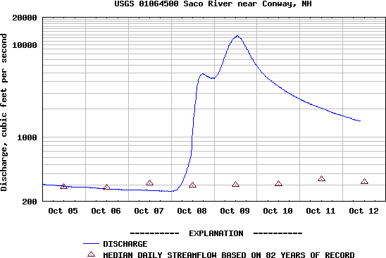 Streamflow for the Saco River |
This is a streamflow chart published on-line by the USGS. It shows the flow of the Saco River which flows south out of Crawford Notch and then follows Route 302 east into Conway. All the Carrigain streams drain into the Saco. There is a huge peak (where the flow goes up almost 100 times) on October 9th which is when we were on the trail. There are 4 stream crossings on this hike (plus a rock-hop). The first is serious and it comes right near the start when the trail crosses Whiteface Brook a few hundred yards from the trailhead. We bypassed this by bushwhacking an easy 10 minutes on the west side of the stream from the road, starting right after the bridge.
 Geri crossing Carrigain Brook |
Bob and Geri took off their boots. My son and I just trudged through. We had to empty out our boots on the
other side, so it's not clear which way was better. I guess we were hoping the water level would not be over
our boots, but alas, it was. The bottom line is you could expect to be able to do this hike in
high water as long as you don't mind getting your feet wet.
| M |
We got some coffee and gas and then started east on the Kanc. When I was here in the summer they were working
on the road just before the turn off to Bear Notch Road, but this time it was all paved over (although there
were still warning signs). The weather was a little better, with just a drizzle, but there were zero views. We
got to Bartlett and drove the 4 miles on 302 to Sawyer River Road and found it was open - Horray!. Two easy
miles on this dirt road brought us to the parking lot at 8:50. And there was the unmistakable Bob&Geri-mobile,
the biggest SUV on the block  .
.
I was very pleased that Bob and Geri, who had been with me for some of the tough peaks in northern Maine last year, were able to make it. On a day like today I would not have been surprised to find an empty parking lot. But it was not raining and Bob gave the optimistic observation that conditions were certainly better than yesterday when they had hiked Jackson. So we got ourselves together and were off and hiking by 9:07.
The first thing was to bypass the stream crossing of Whiteface Brook. We went into the woods just west (left) of the bridge (the same side the parking lot is on) and found it easy going.We stayed on high ground and just followed
 The crossing of Whiteface Brook that we bypassed |
For the next mile and a half or so the trail is very easy. Wide and flat - obviously and old rail bed or logging road. We would occasionally get some drips from the wet trees but it was an altogether pleasant hike on a good hiking day. Along this stretch of trail we kept bumping into very wet overnight campers coming down the trail. All of them looked to be around retirement age, and we assumed they were out together for the weekend. There must have been 10 or 12 of them stretched out over 20 minutes. We told them all about the bushwhack around the stream crossing further down the trail, and they told us about the trail being under water "up to here" - usually pointing to their thigh - further up the trail. We would shortly learn what they were talking about.
We reached the fork in the trail where the Carrigain Notch trail goes off to the right at just after 10 AM. We had taken just under an hour to get here including the bushwhack around the stream crossing. Just after this point the trail crosses Caririgain Brook and then immediately crosses a tributary. The first crossing was wide - probably 30 - 40 feet and about knee deep. Peter and I trudged across (carefully) with our boots on hoping the water wouldn't flow in over the top. Well it did! Bob and Geri went barefoot and kept their boots dry. We were about to empty out our boots but Bob said "hold on, we have to cross another one right up ahead". So we got to that crossing, which
 Long and tiring climb |
The last crossing was about a half mile further on. There was a log part way across this one that allowed us to jump across without getting soaked, and aside from a rock-hop about another half mile up the trail - true, the rocks were about two inches under rushing water - that was that.
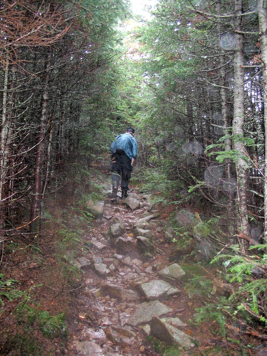
At this point the trail got moderately steep and we were onto the long climb with 3 or 4 long switch-backs up to the ridge. Most of the elevation gain is in this section, and although it's not overly steep, it is long and never really lets up. From the last stream crossing, the trail climbs from about 2000' to the top of the ridge line where we break out of the trees at about 4000' feet. This in just over 2 miles, so this is one tiring climb. But it's also a very attractive section with numerous views across the valley to the east (but not today) and over lots of rock ledges. Some of these had water flowing over them across the trail, and some had water flowing under them. It was uncanny to hear the streams gurgling under our feet unseen, but not unheard.
 Breaking out of the trees in the fog |
The trail goes back under the trees and as it approaches the summit, it curves around to the left. At this point Bob noticed a covered spring just off the trail on the right. There is a lid and when we looked in, there was a deep well with clear water flowing out and down across the trail. None of us had ever read about this spring, but it seemed clean and well maintained. However, I've since heard that the water purity of this well is suspect, so be careful.
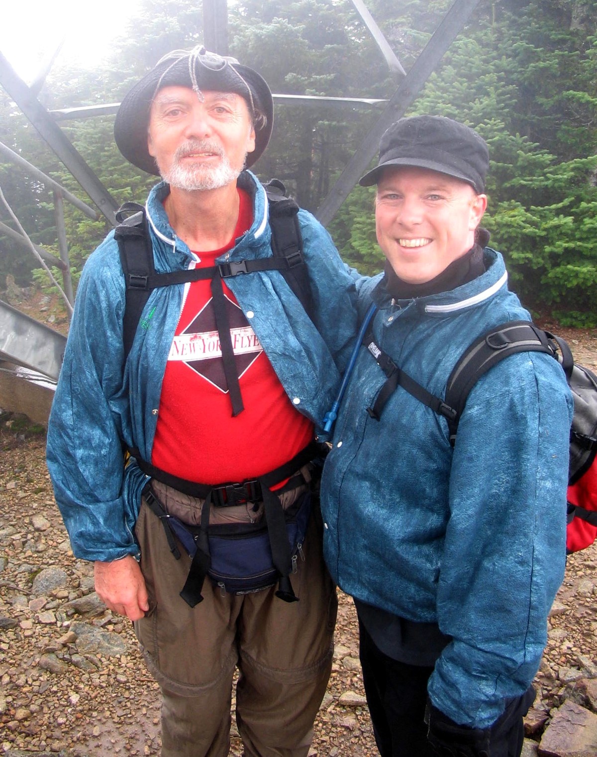
The last few hundred yards of trail rises up through spruce and fir over a slightly steeper rocky trailbed. As per the protocol, I led the way to the summit. Soon the steel legs of the tower were visible in the fog, and at 12:50, there I stood on the summit rock under the tower. It was number 48, number 67, number 100 and number 50! There was no view, but in my memory were lots of views from lots of other mountain tops. It was great to be here, but more importantly, the getting here after those many other climbs was more important than the being here.
My son and Bob and Geri joined me and I was very glad to be able to share the moment with these friends and family. For Peter it was number 1, so he is on his way.
 With Peter |
 With Bob and Geri |
We moved over under the trees for lunch and enjoyed some brews (my favorite: Sierra Nevada Porter) and spirits
(Champaign that Bob had brought). We found a rock for a picnic table and discovered that this was higher than
the summit rock! So we had lunch on the "true summit". I guess all you peakbaggers out there will need to come back and
touch this "true summit" rock or Carrigain won't count!
.
(And don't forget Owl's Head and Scar Ridge while you're at it
).
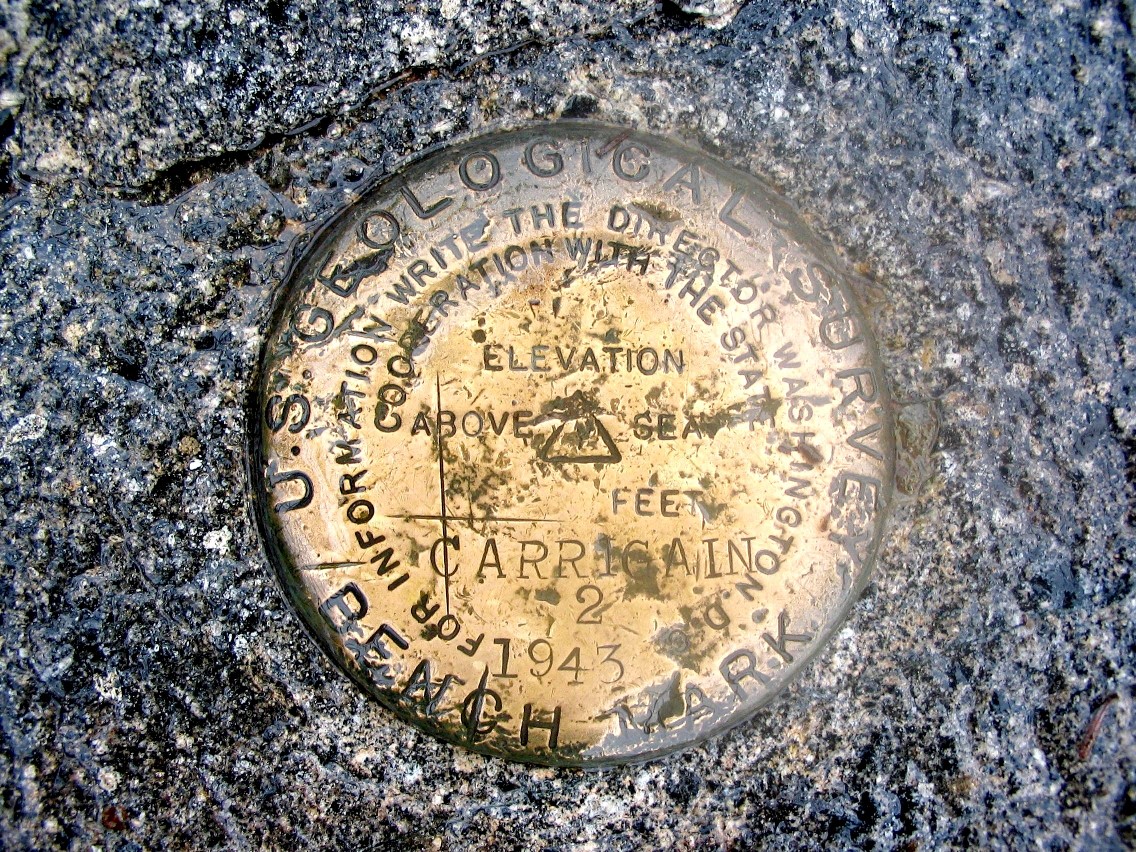 Carrigain benchmark |
 Lunch rock (true summit) |
It was chilly, so we didn't hang around long. The trip down was much easier on our muscles, but tough on our joints. The stream crossings were uneventful - and I managed to not fall in a hole on the way back! We got back to the car just before 4:00 PM - just under 7 hours for the trip. Considering the short bushwhack and the stream crossings, this was a very respectable time.
When we were changing and getting ready to leave, who should show up but Albee from the VFTT internet forum. We saw him come in off the trail and soon discovered who he was, and that he had done Vose Spur solo. We had just missed bumping into him on the trail. He didn't know about the turnoff for Vose Spur at the big boulder, and so went up the face of the Notch! Wow! That's impressive Albee.
Bob and Geri were off to Twin Mountain where they had their trailer and Peter and I were back to the Boston area - via dinner and a Pig's Ear at the Woodstock Station. We got home around 8:15. The road was dry and the sky was clearing (with yes, some foliage) until we got to Massachusetts. Then the rain resumed and it hasn't stopped yet 3 days later.
It was a great and memorable trek.
Mount Carrigain, elevation 4700', prominence 2240'
Distance hiked: 10 miles (round trip)
Elevation gain: 3250'
Time: 6:50
| A |
Worst Experience: Cannon (it was the screaming kids)
Most Rugged and Remote: The Traveler
Best View: Katahdin
Biggest Dissapointment: Sugarloaf (the ugly summit structures)
Toughest Bushwhack: Baker
Nicest Bushwhack: Cold Hollow
Most Pleasant Surprise: Mansfield
The Best Mountain: Katahdin - The Greatest Mountain!
The Best: all my hiking friends!
|
Click here for a complete album of photos from this hike Return to Papa Bear Home Page |