
That's me

That's my stuff
his hike was one of several shakedown hikes leading to my upcoming trek on the Appalachian Trail which will begin in early April.
One of my favorite local hiking areas is the Hudson Highlands. This is an area on the east side of the Hudson River, roughly across from Bear Mountain State Park and the U.S. Military Academy at West Point. I guess technically the highlands include both sides of the Hudson, but the Hudson Highlands State Park is just on the east side. I think of the Highlands as being bounded by two magnificant river gorges where the Hudson cuts through the Appalachians. At the south end Anthony's Nose faces across to Bear Mountain to form one beautiful gorge, and at the north end Breakneck Ridge faces Storm King (just north of West Point), to form a similar, if not more beautiful gorge. This area is full of history and natural beauty.
|
That's me |
That's my stuff |
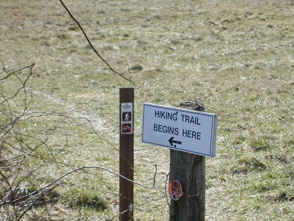
The trail started across a field and skirted some private land before it joined a very well groomed old carriage road. After the mile or so on the roads (I had to keep telling myself to SLOW DOWN), I found the trailhead.
 Simple beginnings ... |
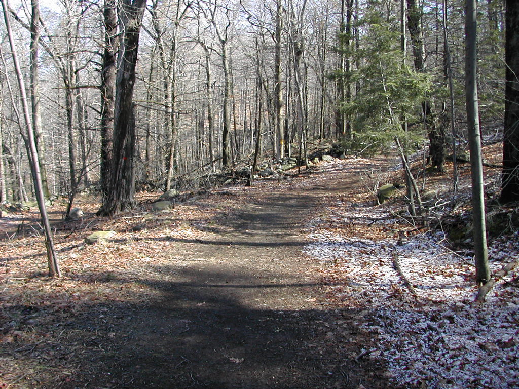 The Sugarloaf Trail was a well groomed old carriage road |
The structure of the trail was very solid with rock erosion runoff barriers, careful grading, rock facing on steep sides and well laid out switchbacks. Clearly the builders of this road, perhaps a hundred and thirty years old, built to last.
On the way up I spotted the castle on the opposite hill. This structure was built in the late 19th century by the grandfather of William Henry Osborn III, who in 1974 donated the surrounding land to the state for parkland.
As the trail climbed along the flank of Sugarloaf I spied this beautiful little pond. If it weren't for a rock dam at one end it would seem to be the most natural of things. It was probably dammed up as part of the original estate that was here over a century ago.
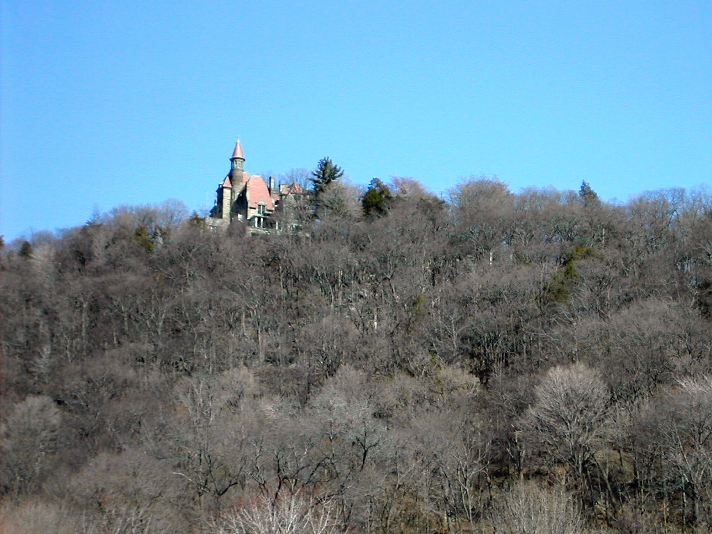 The Castle at Castle Rock |
 A beautiful little pond |
The top of Sugarloaf, although only around 800 ft. high, has good views of both the southern river gorge with the Bear Mountain Bridge and the northern gorge with West Point in the forground and Breakneck Ridge behind. Unfortunately, the hazy day and distance prevented me from getting good pictures.
Suddenly I spotted a large brown raptor just off the crest at eye level. It was certainly not a Red Wing or similar hawk, and judging by the size of the beak in relation to it's head (and it's overall size) I'd say it was an Eagle. Either a Golden or immature Bald. I would go with calling it a Golden by the yellow of its beak, but to be honest, it wasn't a clear identification. Naturally, I could not get either my binocs or camera on it, so let's just say it was "a probable Eagle, possibly a Golden".
After coming down off Sugarloaf Hill, I got onto the Osborn Loop (blue blazed), heading south. The Osborn Loop and the Sugarloaf Trail don't actually cross here, but they just come into and out of the 4 way crossing, sort of like the IRT and BMT subway lines at Times Square.
After climbing a ridge I passed several streams (which were each forded by walking across a series of massive stepping stones). Boy, could they build trails in the "good old days".
 The Mountain Laurel at the start of a side trail |
 Near the end of the Osborn Loop |
I then entered an area where Mountain Laurel covered both sides of the trail. It was the only broad leaf plant in leaf (I believe it's actually an evergreen) and it gave a stark beauty standing below the leafless trunks and branches of the surrounding forest.
Eventually the Osborn Loop joins the Appalachian Trail. About a mile before hitting the AT, I saw a very curious thing: in the middle of the Osborn Loop Trail was a metal surveying marker with the AT symbol. The inscription said "Appalachian National Scenic Trail. Trail Marker. Do Not Remove." This surrounded the AT symbol in a circular fashion.
Around the two sides of the "A" in the symbol it said "222 NY 104 E" with the "222" on the left side of the "A", the "NY" at the point of the "A", and the "104 E" on the right side. I should have taken a picture. Sorry. Anyone know what this is and what it is doing there quite a ways off the AT?
At this point I should have stopped for lunch. I had come about 6 miles and this would make a reasonable turn around point. But since it was only 11:30, and being a mile-hound, I thought I would press on to the Hemlock Springs Campsite about a mile or a mile and a half down the trail. I wanted to check the campsite out, expecially the viability of the water supply.
But my right adductor started bothering me and eventually good sense prevailed, and I stopped for lunch just before South Mountain Pass at the south end of the Canada Hill ridge. I actually didn't want to have to go down the slope to the road knowing I would have to hike right back up, since lunch was my turn around point.
I had a pleasant lunch, and in about 30 minutes started back up the AT. This time I went past the Osborn Loop turnoff and kept on the AT and picked up the other end of this loop trail heading back to Garrison. The distance would be about the same either way. Along the way my adductor started bothering me more and I took a few long rest stops, which helped. At one of these stops an older couple who were hiking from the Bear Mountain Bridge to Route 9 caught up to me and we chatted briefly. It was they who snapped the shot of me at the top of this page. We parted where my trail headed back to Garrison and theirs headed east to Route 9. They were the only souls I saw on the trail the entire day. O blessed solitude! (Although I did see one set of footprints in the snow along the Osborn Loop.)
 A Pagoda along the trail |
 A View of West Point across the Hudson |
When I had got nearly to the end of the trail, I noticed something I had missed coming in: 10 or 15 trees seemed to have some kind of blight. The bark was turning red and flaking off. Some trees were dead; all seemed to be dying. They were generally tall mature hemlocks.
Take a look at these two pictures and notice the symptoms. Does anyone know what is attacking theses trees?
 Notice the red flaky bark |
 Closeup of the same tree |
When I got back to the trailhead and started back on the road to the train, I recalled a time some 26 years ago (it was April 1976 - I looked it up in my notes) when I came out on this same trailhead after hiking down to from Anthony's Nose with my son, then 7½. We asked some local kids where the train station was, and they assured us we certainly couldn't walk that far. Well, once we got the directions we had no trouble walking that last mile or so.
My trek was coming to an end. Unfortunately so was my strength. The pain in my right pelvis had become more constant and my speed was slowing considerably. I'm embarrased to say I missed the 3:02 train back to Grand Central by less than a minute! The train was in the station, pulling out as I was crossing the overpass to get to the southbound platrform. I simply couldn't move any faster. Well what's to do but take the extra hour till the next train arrived to rest! Beautiful rest!
Pb
|
Click for Papa Bear's Home Page Click for the Backpacking Page |