West Quoddy Head Lighthouse
(Click on the picture for a larger image)
|
West Quoddy Head Lighthouse (Click on the picture for a larger image) |
|
This account is divided into two parts: first the vacation highlights with emphasis on pictures (there was no end to gorgeous weather) and a second part which featurs some of the noteworthy survey markers that I found (or alas, didn't find).
|
A Vacation trip to the Bay of Fundy
n September (2007), my wife and I spent a wonderful 10 day vacation in Downeast Maine and New Brunswick, Canada, exploring the Bay of Fundy. Not only were there limitless sightseeing oportunities in both Maine and New Brunswick. But in addition to the "tourist stuff" there were myriads of old survey markers (commonly called "benchmarks") in the area. Finding old survey markers like these is one of my hobbies So I wanted to intersperse the occasional search for an interesting survey marker with the touring we planned to do through this beautiful area - but I had to be selective in what I went to look for (after all this was a vacation first, and a benchmark-hunting trip second). This combination vacation/benchmark-hunting trip took not a little understanding on my wife's part since several of these stations involved lengthy bushwhacks and trips of 2-3 hours (she typically read a book in the car), and for that I thank her dearly.
Click on the index below to read about any specific day:
Tuesday, September 18th - Getting There: Addison Maine
e left on our trip from our son's place near Boston. We picked up the rental car aroung 8:00 AM and headed up I-95. The B&B where we were headed for tonight, was supposedly a 7 - 8 hour drive. We would be on the interstate untill Bangor, and then we would be taking smaller (and smaller, and smaller) state roads. Our destination was The Pleasant Bay Bed and Breakfast in Addison Maine, way downeast in Washington County. We took a break in Brewer, just past Bangor, for lunch at the "Muddy Rudder", a pleasant spot on the Penobscot. Then we headed east on US Route 9 and finally took state route 193 south. This was a very deserted road and we knew we were moving further and further into another world. At one spot along the road we saw a huge array of shacks - we later learned it was for migrant blueberry pickers. We hit US route 1 in Cherryfield and a few small towns later found the turn-off to out B&B.
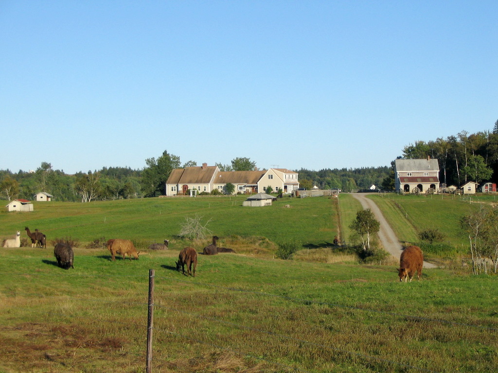
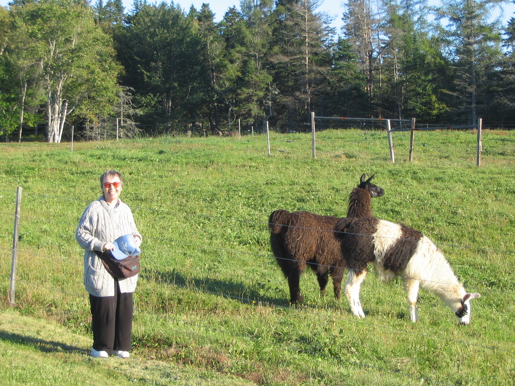
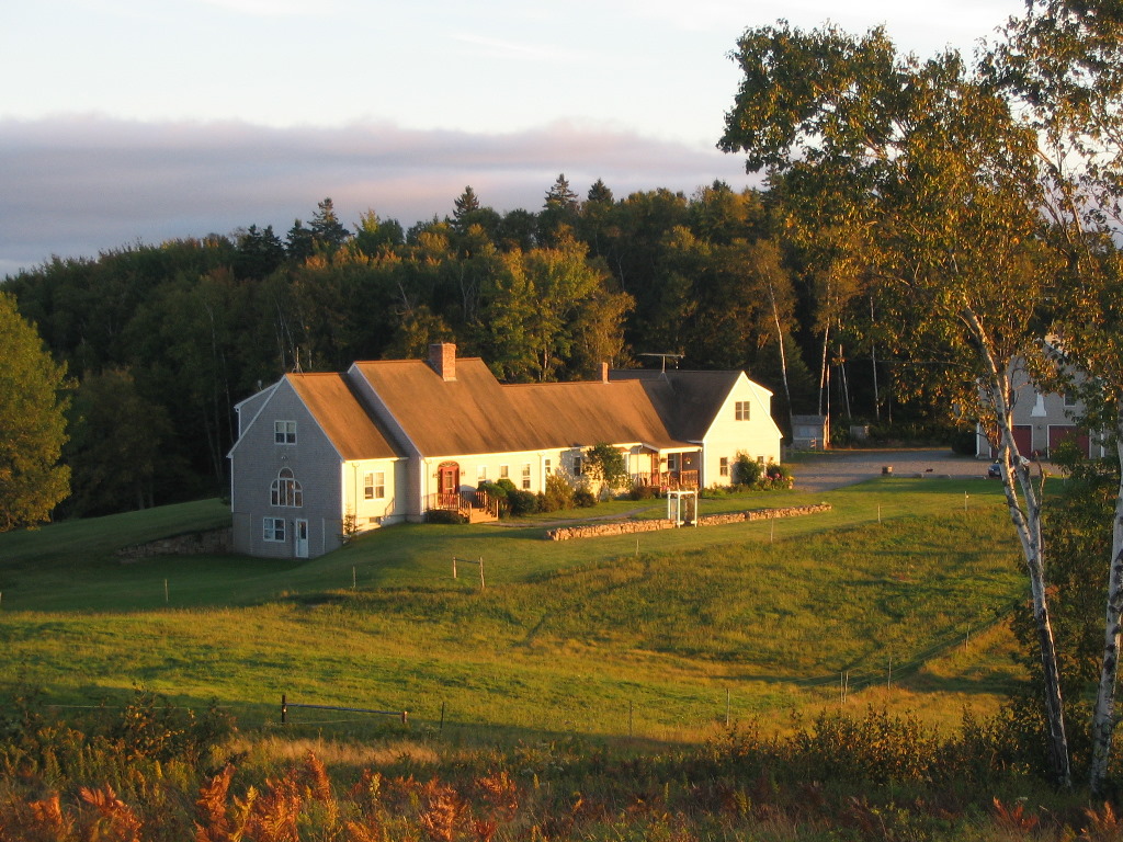
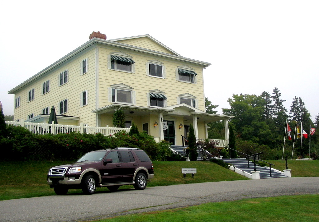
When we arrived in mid afternoon, we were surprised by a field full of llamas and an attractiuve old farm house on the bay. We met Leon and Joan Yeaton, who owned and ran the B&B. They had renovated the building and it was a beauty inside and out. They said they had decided to raise llamas (ewhich produce very costly wool) after buying the property. Everything about the place was in great shape. It being mid-week, we had the house to ourselves except for the elusive "Doctor" who supposedly stayed in the room next to ours. We suspect we heard him rising ealy the next morning but he was gone befor we took our breakfast. In the two days we stayed, we never saw him.
We spent a good bit of time exploring the property and drove around the area before heading west on route 1A to a little restaurant in Milbridge called "44 Degrees North" and had a fine small town meal. It was a good travel day, with time left over for some local sight-seeing in unseasonably warm sunny weather. A great way to start our vacation.
Complete album for today's photos: Album Wednesday, September 19th - Exploring Jonesport, Machias, Trescott & Machiasport
oday we would explore the Maine coastline to the East and we would wend our way almost as far as Lubec (where we would be heading the next day). The weather was once again magnificent and travelling mid-week late in the season left us almost without any tourist competition. First off we headed down to Jonesport which lay at the end of the next head of land past Addison. The bridge at Johnsport took us across a small channel to Beals Island. This is a fishing port and most of the boats seemed to be in and the lobster pots and buoys were out drying. This was s beautiful working community.
Back across to the mainland we visited Johnsport with it's old churches and Victorian Guest houses.
Next came Machias, the county seat of Washington Couty and a mighty metropolis it was indeed
I asked if the dirt road was likely to be drivable. Then followed perhaps the best quote of the week: "Are you kidding? Around here you can't ever drive the paved roads!" After a good chuckle we got going; we drove on about 8 miles to where the map showed the hill and inquired of a guy working on boat in his driveway. He had never heard of it either but finally said "That must be Wayne Jones' Road". He said it was a town road open to the public so we went back and found the turn-in and parked the car. There were a few small houses on one sde and some trailers on the other. No one was around to ask, so I went off into the woods following some directions written in 1960. This unlikely search for a 146 year old copper bolt in a rock ledge on the peak of an overgrown hill, using directions nearly 50 years old was an unexpected success. See below for the report. Some 3 hours later (including about an hour's worth of bushwhacking through shrubby woods), when I found my way back to the car, there was Wayne Jones himself, with assorted children and grand children around our car talking to Joy. Like a typical Mainer, Wayne, who owned "this side of the mountain", was only too glad I found whatever it was I was looking for.
We arrived back in the late afternoon, and after a shower and nap, it was off to "44 Degrees North" again for dinner. A long, tiring but very rewarding day.
Complete album for today's photos: Album Thursday, September 20th - Exploring West Quoddy Head, Lubec & Campobello Island
oday would be busy. We would be leaving Pleasant Bay B&B (never having seen the elusive "Doctor" who was our fellow guest) and head to Lubec, about 30 miles down the coast ("down" as in "down-east" means northeast, which many non-Mainers might call "up" the coast). Getting to Lubec would be simple enough but we wanted to explore 1) West Quoddy Head and 2) Campobello Island as well, which would make for a full day.
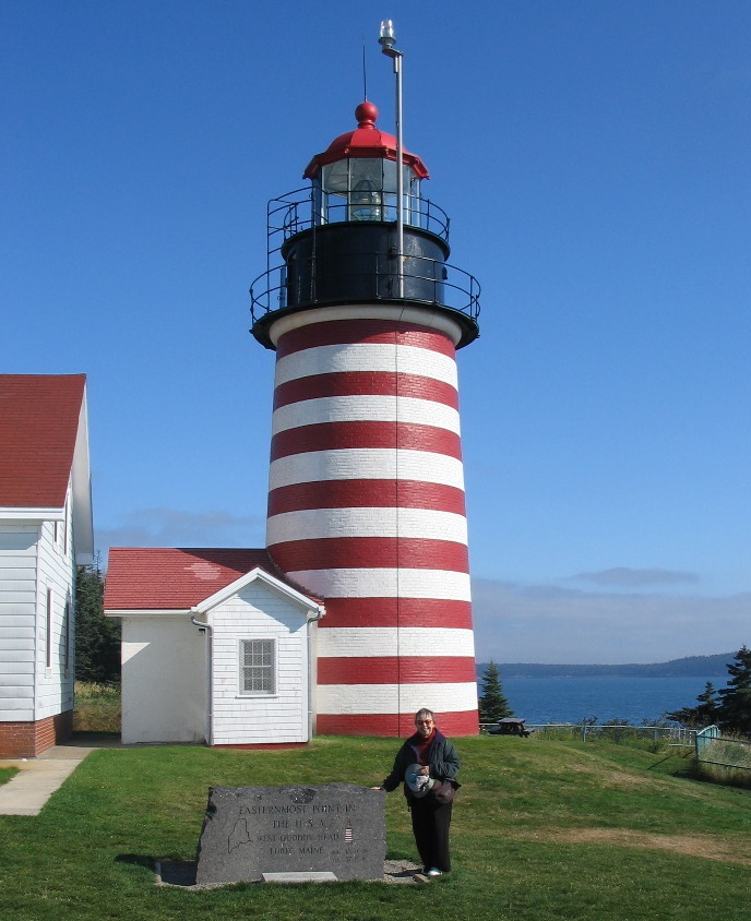
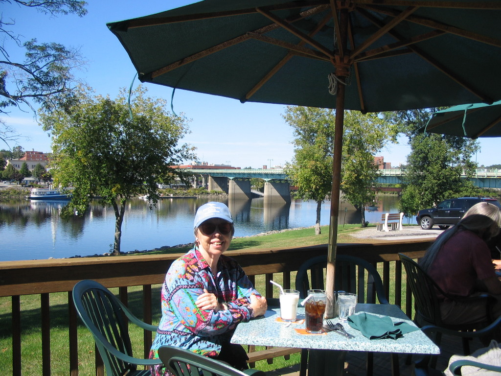
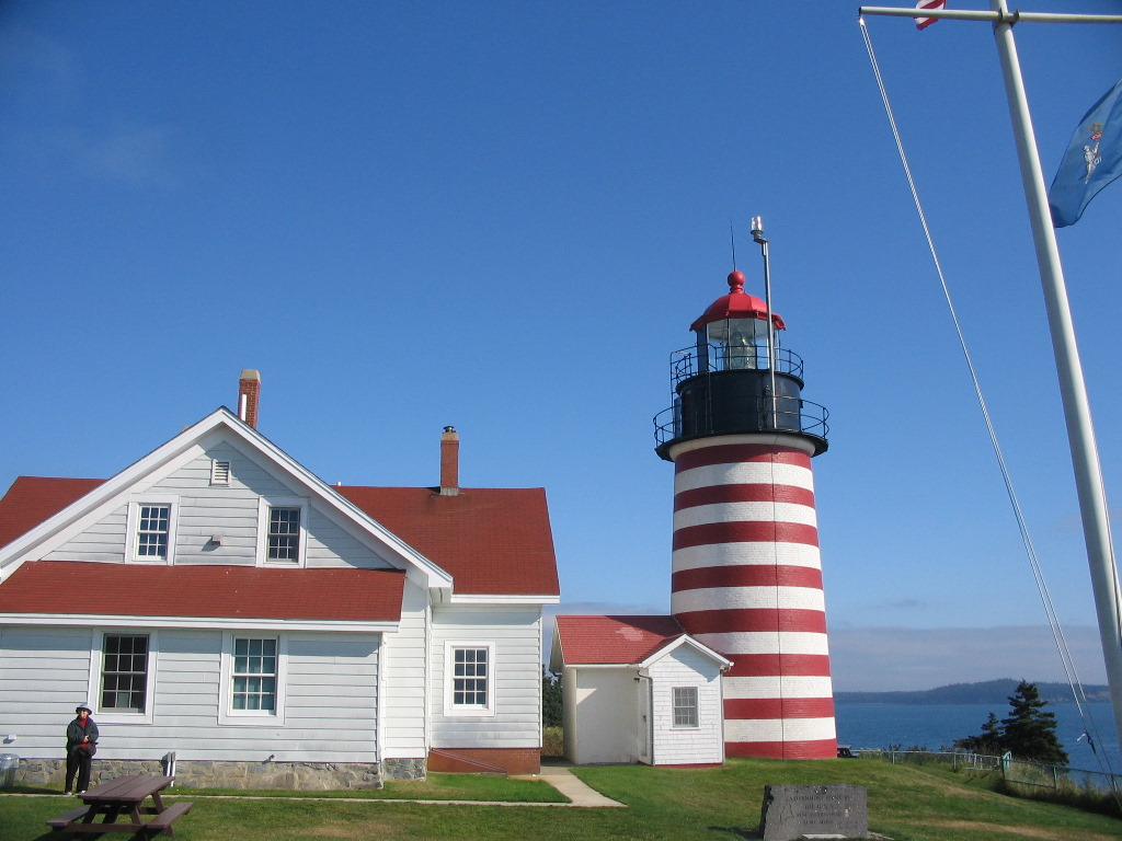
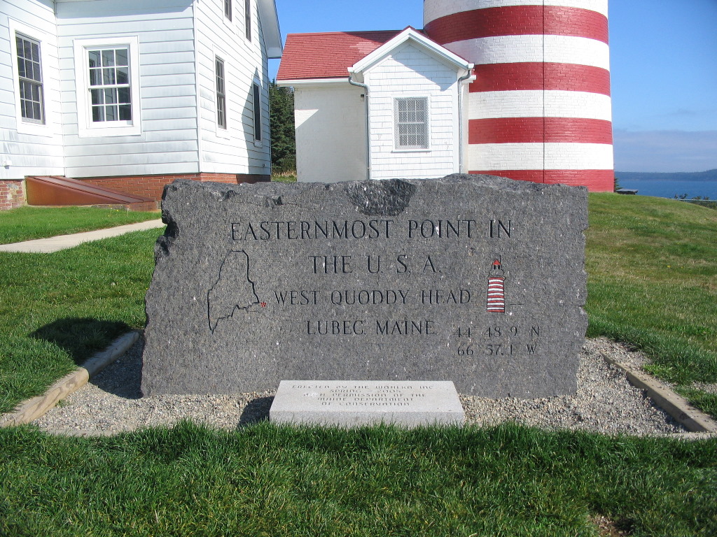
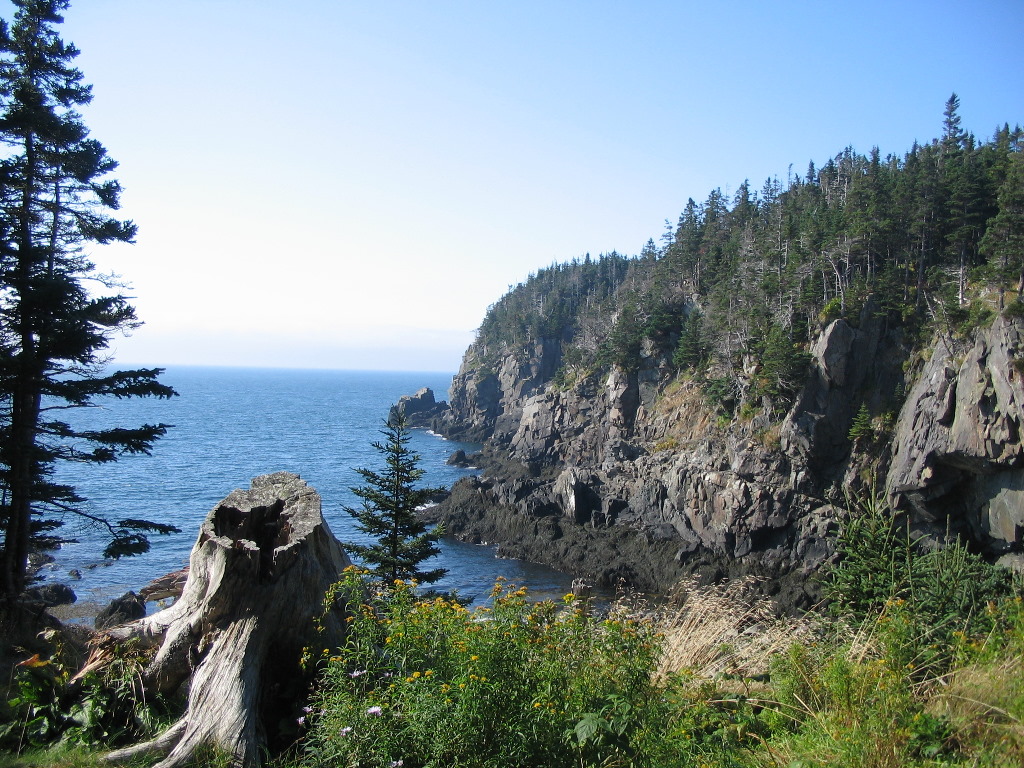
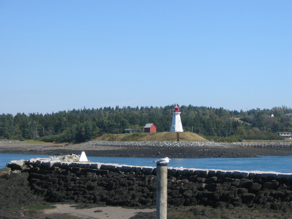
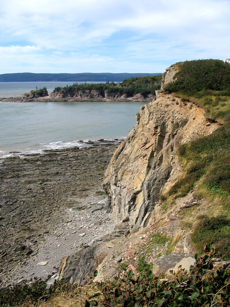
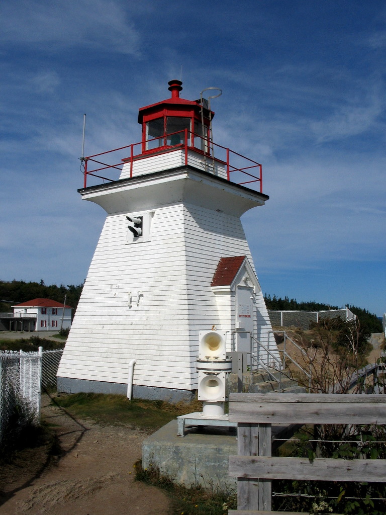
We got an early start after the usual scrumptious breakfast and reached the very end of West Quoddy Head, a peninsula just west of Lubec which forms the U.S. side of the entrance to Passamaquoddy Bay. Just a few hundred yards across the Quoddy Narrows lies Campobello Island, part of New Brunswick, Canada. At the northeasternmost point of land stands the picturesque West Quoddy Head Lighthouse. A marker there proclaims: "Easternmost point in the U.S.A. / West Quoddy Head / Lubec Maine". The lighthouse visitor's area was about to open so we were just in time. Now you might ask "Why would the easternmost point in the U.S.A. be named West Quoddy Head?" Easy, it's on the west side of the Quoddy Narrows which separates Maine from Canada. East Quoddy Head is at the other end of Campobello Island, in Canada. We checked out the visitor's area, asked a few questions and then took a walk along the sheer cliffs. This area of water is at the southern end of the Bay of Fundy and like the rest of the bay, gets impressive tides. We couldn't actually go up inside the lighthouse, but it was a beauty to see nevertheless.
On the way back from the lighthouse we made a couple of stops. First I tramped through the woods at just the right point and checked out the boundary Range Marks that I had determined were there. These markers were set in 1912-1915 when the border was surveyed. By aligning the markers in a pair, the observer could determine the exact placement of each turning point of the boundary as it was laid out through Passamaquoddy Bay. This particular pair is the easternmost pair on the US side of the line. Originally they were large concrete pyramids, but many of them have been replaced over the years by steel triangular markers.
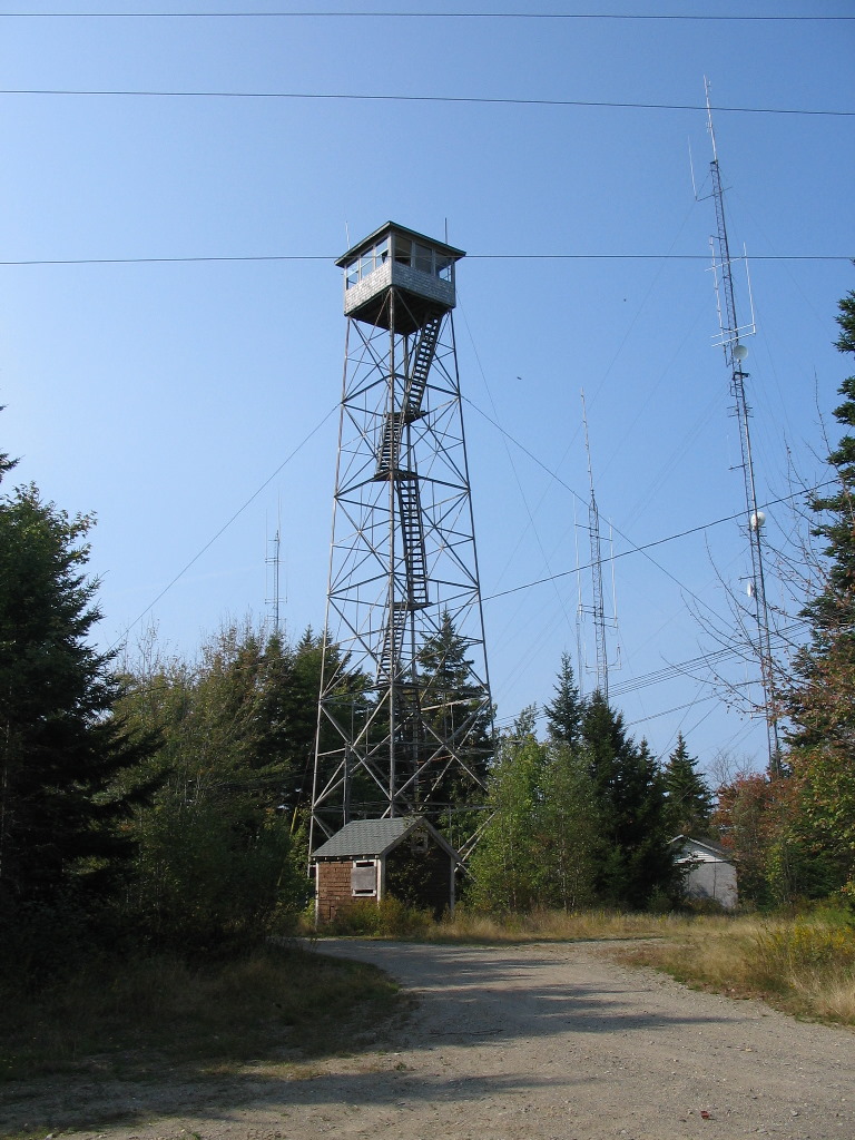
Berfore driving into Lubec, we made one more stop - at the old Coast Guard station. This station was station #1 in the original Coast Guard numbering scheme, since it was the first one along the coast starting in Maine. It's now a lodging (Quoddy Head Station) and we chatted with the young man who was looking after the place. Leaving Joy to read in the car, I took a quick hike up the hill along the old woods road which is directly across from the station. There is an observation tower on the top (unfortunately the observation platform on the top was locked) and on a nearby point, the old survey marker set in 1860 as part of the original survey of the area. I was lucky to find the marker - it was a copper plug in a drill hole marked by a small cairn - since the area was covered by nearly 150 years of moss and lichen. (See report below for some detail on this mark).
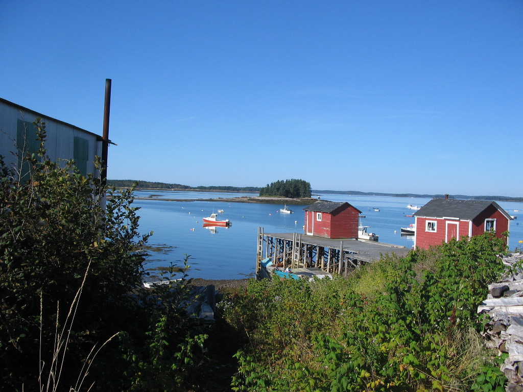
We got to Lubec just in time for lunch. Lubec is an old town which was a major fishing port in years past, but unfortunately time and the fishing industry has passed it by. It's a lovely tourist destination and I highly reccommend it, but some of the older parts of town are a bit run down. We found a lunch spot (Clam chowder - but of course!) right on the waterfront. There was another lighthouse right across the channel in Canada and several more of the boundary Range Marks. (See report.)
We didn't have a lot of time, so we found our B&B (The Home Port Inn), checked in and dropped our stuff and then we were off to Campobello Island. Campobello is a short hop over a bridge from Lubec. It was never a fishing port and was traditionally a summer destination for wealthy Americans, so it has retained it's character and charm. It was most well know as the summer estate of the Roosevelts; FDR spent his summers there as a child and vacationed there through the time of his presidency.
The Roosevelt Estate has been preserved as a park (the The Roosevelt Campobello International Park) and is a lovely place to visit. Luckily, the tourist season was over so we had the tour to ourselves. But before stopping at the Roosevelt Estate, we drove to the north end of the island to see East Quoddy Head lighthouse. This is separated from the main island by a shallow channel about 30 yards wide. At low tide you can walk across on the rocks and see the lighthouse up close. But if you don't watch the clock you will be stranded for about 8 hours. The cold fast moving tide rises about 6 feet per hour and the narrow channel becomes an impassable moat. Finally we made our way back to Lubec and had a nice dinner at a seafood place down the road. At the Home Port Inn there was a full complement of guests and when we got back from dinner we spent some time chatting and making their acquzintance in the well appointed sitting room.
Complete album for today's photos:
Album
Friday, September 21th - Traveling to Saint Andrews by the Sea, NB via Calais, ME
riday was a big travel day for us. We had to get back onto Route 1 and make our way up to Calais, Maine and from there, cross into Canada. Then we would head down to the town of Saint Andrews-by-the-Sea where we would be staying Friday night. This trip was much longer than the crow flies, since Calais was the first crossing to the mainland of Canada and the road circles around Cobscook Bay adding many miles to the route. To put it in perspective, it's about 3 miles from Lubec to Eastport Maine by water, but it's almost 40 miles to drive around the bay. Click for map, and you'll see. We also wanted to make another short trip to Campobello Island to check for a survey marker, and we stopped at 3 or 4 places along the way for sight seeing, lunch or marker hunting. All in all it was about 50 miles driving to Calais and another 20 to Saint Andrews, but it took us most of the day. Today was the Autumnal Equinox and it was one of the few days around the equinoxes where the sun first rises on the USA due east, and with good weather and an early rise, one could see it from the tower on West Quoddy Head. Well, I didn't feel like getting up at 5:00 AM and it was too foggy anyway, so we gave up that idea. But as I mentioned, I did want to look for a survey marker on Campobello Island that I had missed the day before. It was set as part of the boundary survey done in 1910 - 1915 (which fixed the exact boundary down the Saint Croix River and through Passamaquoddy
Then we reentered the US and drove from Lubec around Cobscook Bay and got onto Route 1 in Whiting and started up to Calais. The Bay from this route was startlingly beautiful so when we saw a sign for "Cobscook Bay State Park", we of course turned in. We walked around and took a break overlooking the bay. It's well worth a stop if you ever come this way. We planned to head to Calais for lunch but make a couple of stops along the way to try and find survery markers which were set along the St. Croix River in the survey of the boundary line in 1910 - 1915. We had mixed results for these side trips. The first was in Robbinston, where the St. Croix River empties into the bay. The marker we were after was the first boundary Reference Monument along the river, No. 246 (they numbered them from north to south, so No. 1 was way up at the river's source in Arroostook County). I stopped at a house where the marker should have been, but no one was home. So I walked over to the edge of the river and spotted something on a rock. I thought this was it, and took a bunch of photos, only to discover later (after
I had better luck with monument No. 231, about 10 miles further up the river is a park just before you get into the center of Calais. It was sitting pretty, right next to another survey marker in the same rock which was put there years earlier. Two for the price of one. See the logs below for more details QF0751 and QF0752. Once we got to Calais we checked in at the tourist information bureau to find out how to reach the historic site of the old Calais Observatory. The woman working there, although she had lived in the town all her life, had never heard of it. After looking over some maps with her she said "Oh, that must be the vacant lot with the funny rocks on the hill next to the nursing home". So with that, were found our way to the spot and got a sense of this important historic spot which had been all but forgotten. We took a few photos and then had lunch in town. But before continuing on, we decided to drop back to the tourist bureau and chat with the woman. She then recalled that a group of officials and the local historical society had been there about 5 years ago at some sort of dedication. See the log below for more details: QF0763). At this point we crossed the international bridge, waited about 15 minutes to get through customs and set off for Saint Andrews-by-the-sea. The exchange rate had recently changed and it seems an inordinate number of Canadians were crossing into Maine for bargains of all sorts at the local stores in Calais. I'm told the bargain hunting traffic is usually in the other direction. Two things drivers should remember when entering Canada: 1) the price of gas is marked in Canadian dollars per liter - not gallons - so although it looks cheaper, it's actrually much more expensive, and 2) the speed limit is in kilometers per hour so you might well get stopped for speeding. When the sign says "80" it's really around 50 MPH on your speedometer! Beware - you have been warned!
After less then an hours drive, we made it to this loveliest of towns at the south end of the peninsula jutting into the upper reaches of
Passamaquoddy Bay, almost directly across the St. Croix River from Robbinston Maine
Click for map.
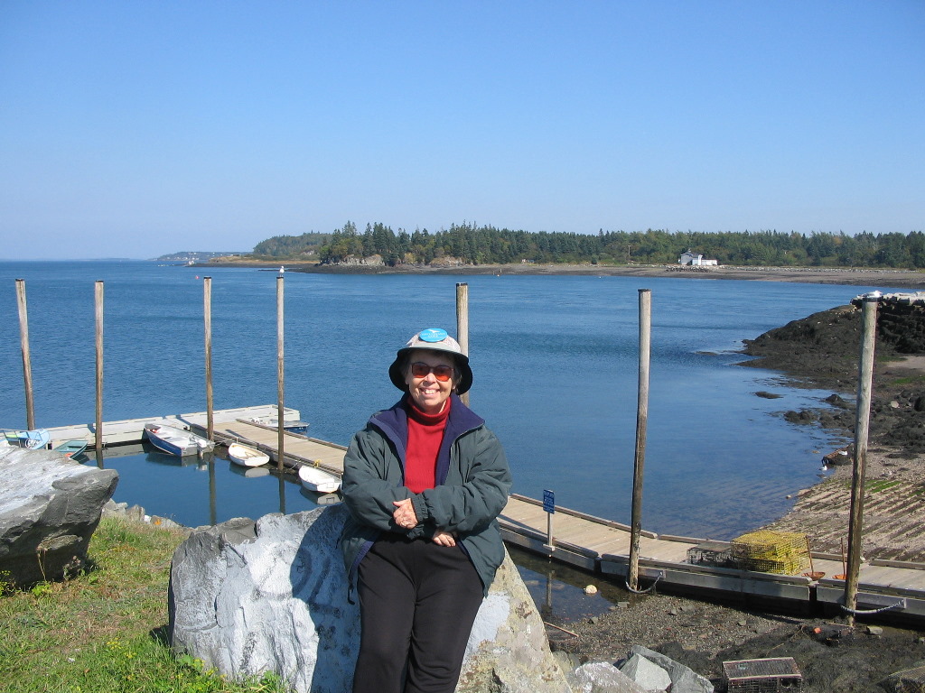
Like all the places we stayed, this was as lovely as can be and was within walking distance of the waterfront with lovely views and nice restaurants. It seemed to be a rather up-scale town dominated by the huge Algonquin Hotel (and equally impressive Algonquin Golf Course). Although we had lost an hour on the clock when we crossed into Canada, we still had ample time to expore the area. We drove around town and found a science center and aquarium (The Huntsman Marine Science Center), that Joy wanted to checked out (she would return the next morning). While she did that, I found the northern most boundary Range Mark (marker #1, which pointed to the position of the uppermost turning point of the bay) which was at the river's edge on the edge of the Algonquin Golf Course. The only thing mysterious was that these markers always came in pairs: I had found the forward marker, so where was the rear marker? I saw nothing up the hill, so maybe athe Golf Course had obliterated it? That seemed unlikely since these were important monuments set by the government. Finally as I was getting into the car, I noticed a fairly fancy house surrounded by a high fence. I peeked through a narrow slot in the fence and what do you think I spied? Yes, there was the monument in the owner's yard: (fenced in Range Mark). A six foot high massive concrete pyramid. Quite a lawn ornament! Mystery solved! (See report.)
The final stop of the day was the Gables Restaurant, which is directly on the waterfront with an open air patio right on the water. This is where we enjoyed our wonderful meal (sea food, of course!) but we were sure happy that we had remembered to bring our sweaters. It cooled down rapidly as the sun went down. Besides the scrumptious meal, we were treated to two special treats, free of charge: a beautiful sunset, and a nearby table of ten very drunk men who were evidently on a golf vacation. It was all in good fun!
Album for today's photos: Album Saturday, September 22th - Traveling to Saint John via Chamcook Mountain
oday was to be the relatively short drive to Saint John, where we would stay three nights, so we could afford a few side trips. First stop was to return to the science center in Saint Andrews where Joy wanted to see a film presentation on marine life in the Bay of Fundy. While she was doing that I made a few explorations in the local area. I picked her up when the film finished and we were treated to a throng of
 . .
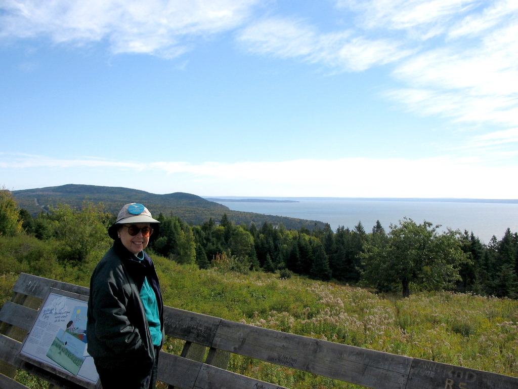
Then for the daily dose of benchmark hunting (and the last such side trip till we returned to the U.S. four days later) we headed about 4 miles north of Saint Andrews to The Rosemont Inn. Behind the Inn stood Chamcook Mountain with a well groomed carriage trail to the top. The original owners of the land used to take guests to the top of the mountain to see the extroadinary views and perhaps to have afternoon tea. The day of horse drwn carriages is long gone, but the old grassy road was well built and the half mile walk to the top is (I am sure) still a pleasurable excercise for the more adventurous of today's guests at the Inn. In 1857, long before the Inn was built, the surveyors of the US Coast Survey found the views from the top equally attractive, and esetablished station "Chamcook" there, the northeastermost survey station of the entire east coast. It was one of the 9 primary stations in this, the first section of the survey of the east coast of the US, and no less that 7 of the 9 primary survey stations were observable from this station.
To a benchmerk hunter it was attractive since 1) it was so old, 2) it was vitally important to this early survey and 3) it was in Canada which might pass for "exotic" in this otherwise rather geeky hobby. I was not dissapointed. After about half an hour of searching and scraping away moss and leaf litter, I found the original copper plug and 5 of the reference marks that sourounded it. I was quite delighted. See the report below. While I was having this adventure at the top of the hill, Joy was enjoying some quality quiet time at the bottom. We had chatted with the proprietor of the Inn and said that we were interested in reserving a table for dinner. She said they were booked up for the weekend, but we took her card and said we would would possibly call for a Monday night reservation on the way back from Saint John. In fact this was a bit of a ruse since their price list was way out of reach for us, but (we think) it put her in a solicitous mood, and she readily gave us permission when I asked (seemingly as an after thought) if I could climb the hill behind the Inn. After we got going again, we drove up the east side of the Saint Andrew peninsula and rejoined Canadian Route 1 heading towards Saint John. We passed through Saint George and after about another hour we were at the outskirts of Saint John. (There sure were a lot of Saints: Stephen (opposite Calais), Andrew, George and now John).
So what is the "Reversing Falls"? The River crosses through a relatively narrow passage between two bluffs between Westside Saint John and the
downtown area. This narrow strait separates the upper bay ("Grand Bay") from Saint John Harbour on the Bay of Fundy. There is an underwater
rock ledge across these narrows. When the tide goes out, the water pours over this ledge into the waters of the Bay.
When the tide turns and comes in (it rises almost 30 feet at this point) it eventually overwhelmes the outflow of the river and starts flowing
over the ledge into the upper bay. While we were there it was still flowing out but was
rather slack so what we saw was a bit of an anticlimax. But the conditions were right for tourist boats to move up into the upper bay.
Look at the photo and notice the high tide lines on the rocks and you will get a sense of how high the tides
are and remember this was half tide so the total swing of the tides is about double that.
After a nice lunch at The Falls Restaurant (note: we had our lunch at the inexpensive lunch restaurant; there is also and a more expensive dinner restaurant at Reversing Falls - we would check that out a few days later) we headed to our home for the next three days, A Tanners Home Inn. In Uptown Saint John, this is a lovingly restored 3 story town house. Originally built in 1887 by a local tanner, it was bought in 2002 by the present owners, Terry and Mercer Munn. It's within walking distance of Kings Square North and any number of restaurants and other points of interest. If you're going to Saint John, I highly reccomend this B&B. We spent a few hours in the afternoon doing some sight seeing on foot, including a local art and crafts fair in and around King's Square North. Then upon the recommendation of Terry Dunn, we enjoyed a marvelous dinner at Billy's Seafood Co. a short walk from the B&B. The day was short in miles but long on delightful experiences. The next day we would start our explorations of the coast north of Saint John. Tonight we would sleep well. Complete album for today's photos: Album Sunday, September 23th - Exploring the Bay of Fundy, Part 1 - The Fundy Trail
ur first full day in Saint John was a Sunday, so we thought we would try to find a church. There were several historic looking churches on the high part of Saint John that you could see from miles away. We found one, Trinity Church, which was "Church of Canada" and we thought this might be close to what we were used to and it was only five or six blocks from the B&B. Terry called and found the time of the sevice so off we were.
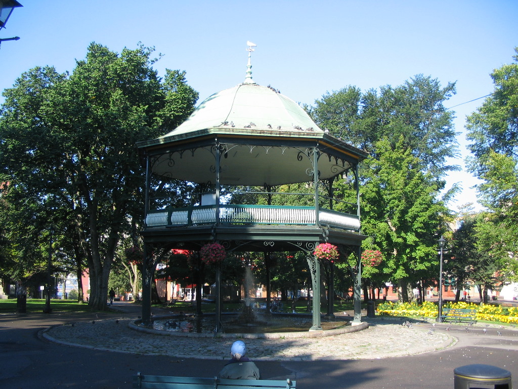
We didn't manage a photo of the church, but we did get a nice shot of the bandstand in the nearby Kings Park North on the way back from the church.
I case you're wondering how the band gets up there, evidently a moveable stairway is put up on one side on band concert nights. There was one
disheviled man hanging around there and talking to unseen companions, but far from bothering us, he made us feel right at home.
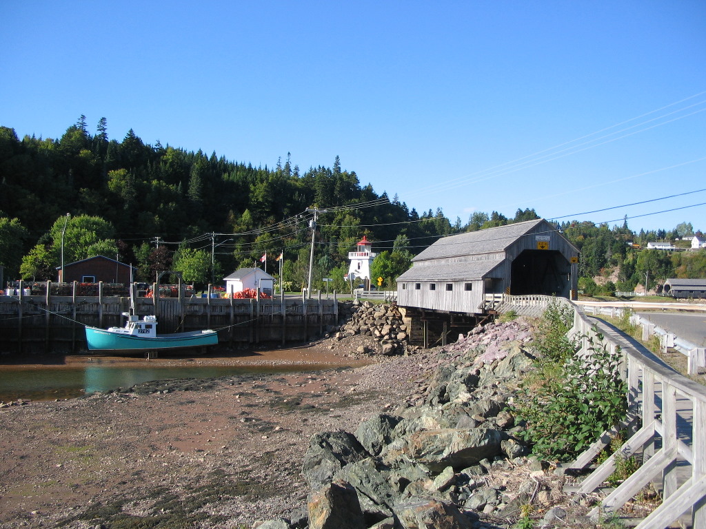
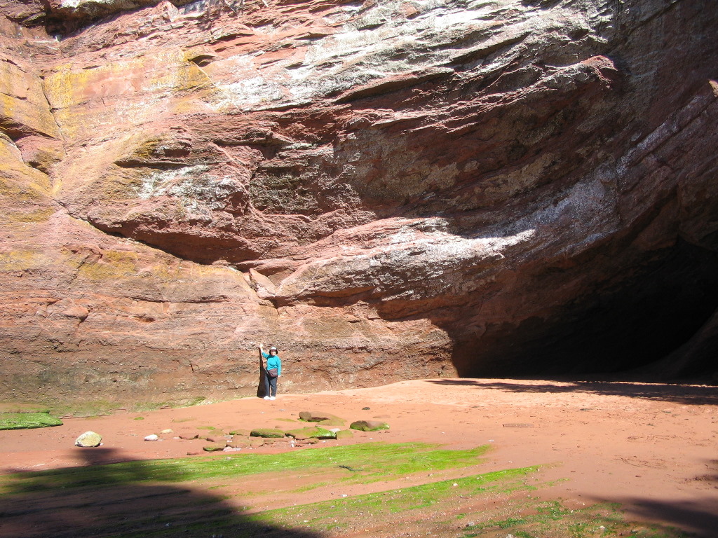
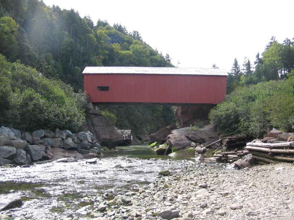
We got back to the B&B and after getting ourselves organized we took off up the coast to Saint Martins. There we would get lunch, explore the Sea Caves and then explore the Fundy Trail Parkway, a scenic drive (and bikeway) along miles of undeveloped coastline. S Saint Martins - Lunch by the Sea Caves (see map). Saint Martins is a small coastal town about an hour north of Saint John, reached via Route 111. It's actually a quaint fishing village reminiscent of some of the towns in Maine, but it also has a few fairly unique tourist attractions. There's a pretty covered bridge you cross as you get into town that would look at home in Vermont. Except it's practically on the beach and when you look at some of the fishing boats moored there, you can't help but notice what enormous tides must flow in and out. Look at the fishing boat sitting on the tidal flat well below the high tide line in the first picture and you'll see what I mean. We stopped for lunch a short distance past the bridge at a restaurant ovelooking the St. Martins Sea Caves. These are hollows caused by the tides in the base of the softer rocks of the bluffs along the beach. We enjoyed lunch in a restaurant overlooking the bay, and then walked along the beach and across a small stream to explore these caves. There are 3 caves, and they only go in about 20 or 30 yards, but the extent of the tidal erosion is impressive. The second photo below shows the height of the tide line next to the opening of one of the caves.
Fundy Trail Parkway (see map). After we had our fill of lunch and finsihed exploring the caves, we drove further on Route 111 and soon got onto the Fundy Trail Parkway. Through the use of easments or land purchases, the Province of New Brunswick has constructed a beautiful meandering highway, accompanied by a bikeway that cuts through uundeveloped logging lands along the coast. It's a dead-end out and back road, but futue plans are to extend it and connect up with the road system of Fundy National Park another 30 miles up the coast. Opening this section of the coast to the public in a non-commercial way while preserving the character of the land is nothing short of stupendous. I can imagine the temptation to start selling off pieces of this priceless area for condos, golf courses and mega-mansions must have been very strong. I assume the logging operations will continue but their impact on the experience of traveling this route was not noticeable.
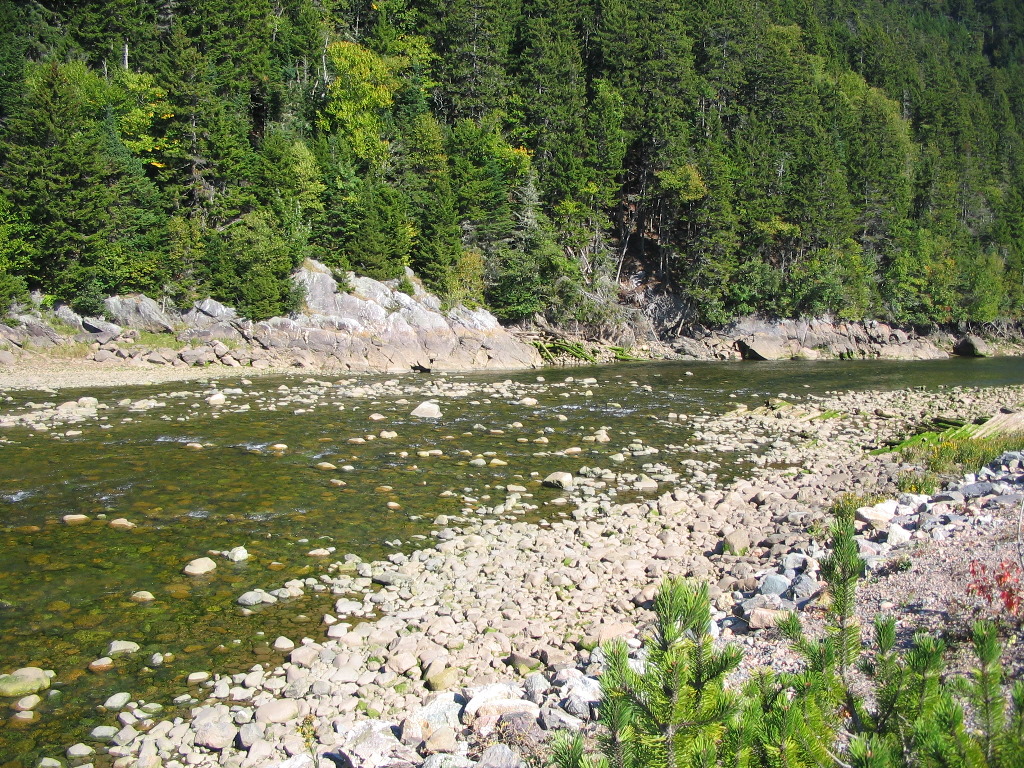
The current parkway ends at the Salmon River, a historic logging route. The construction of a bridge over this river is underway as part of the future expansion of the road, but the river itself is still a pristine waterway. Here's a shot of the river with the bridge construction visible in the back on the far side of the river. The logging runs which ended some 40 or 50 years ago are long forgotten. We drove straight to the end of the parkway at the Salmon River, explored the area around it and then worked our way back to the start, stopping at each interesting spot. It should be emphasized that this road was not constructed like a typical highway, which would tend to plow through the topography of the land in as straight a path as possible.
This parkway follows the lay of the land in all its ups and downs and was intentionally laid out to optimize views and to approach noteworthy natural features. In some sections it lays close to the coast and in others it lays further inland. I would assume for the most part it followed old logging roads when it was laid out.
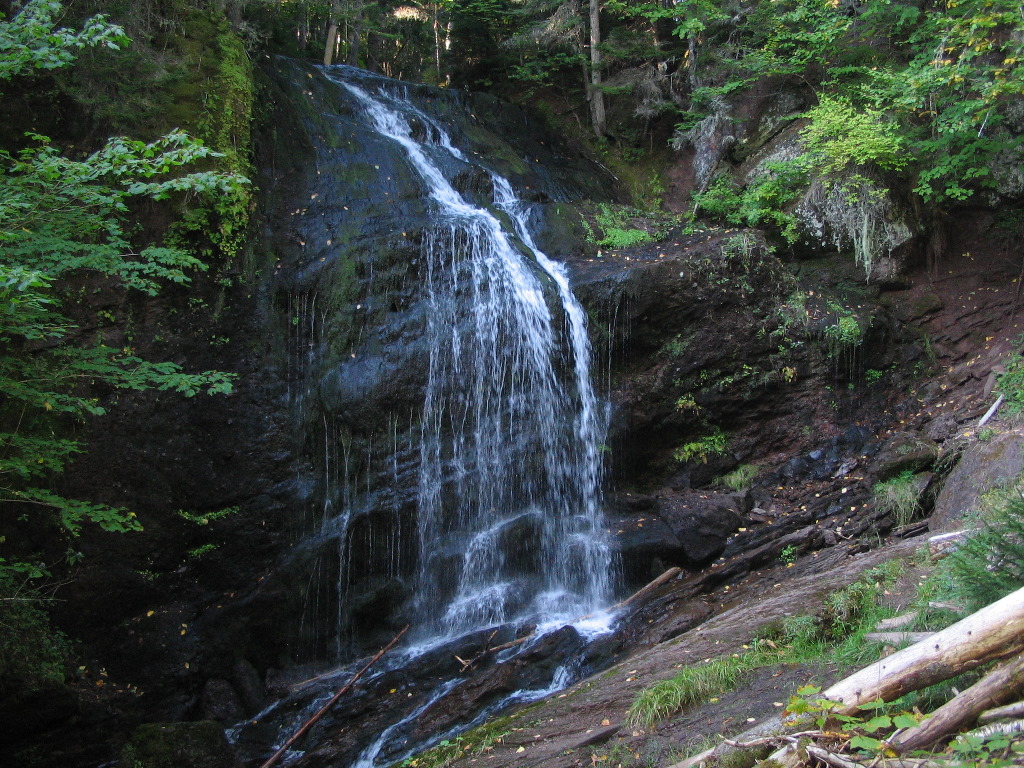
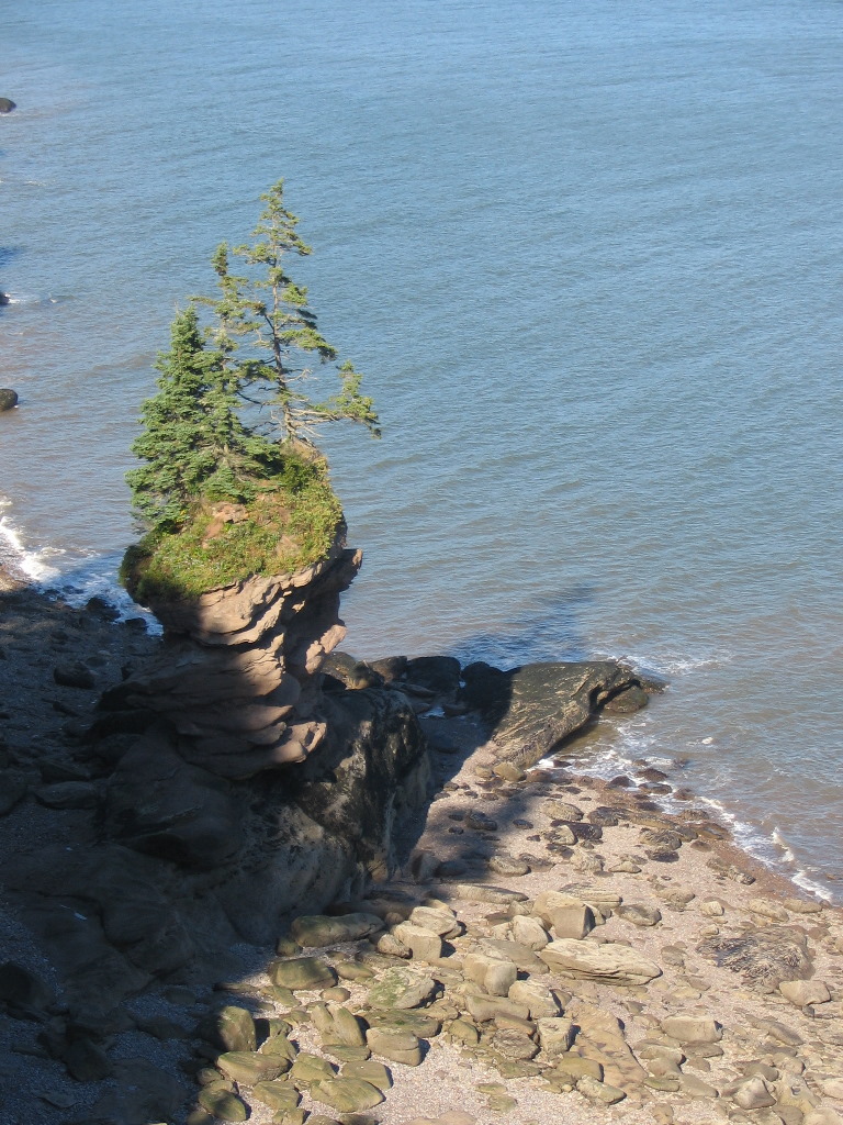
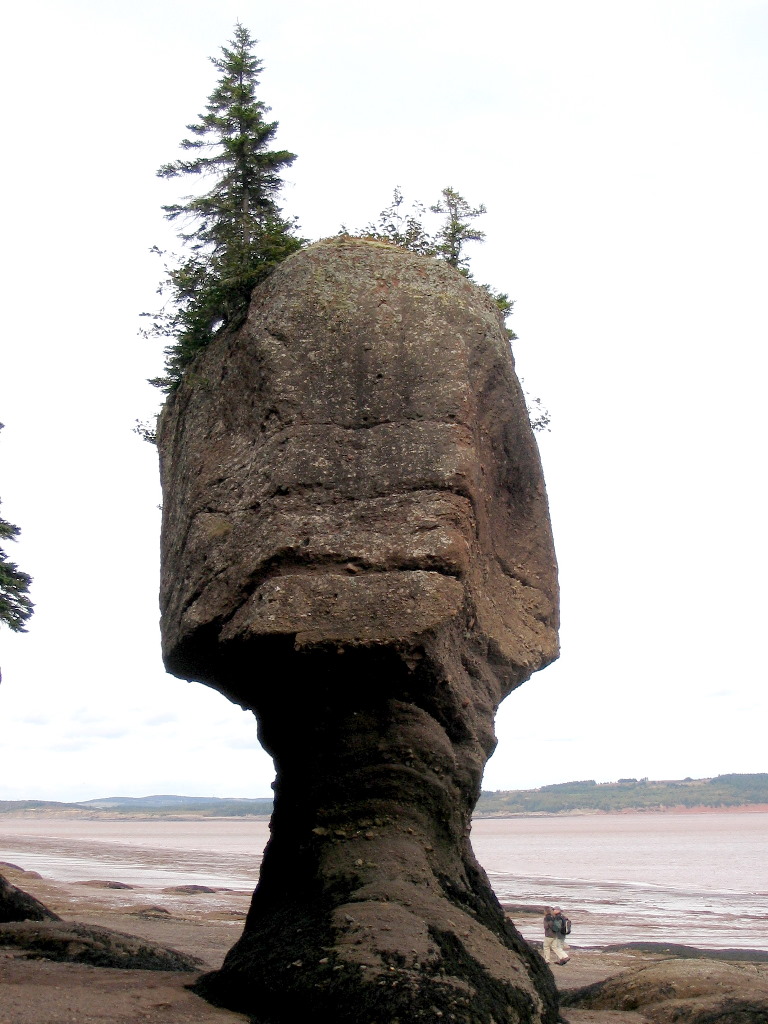
Two gems which we found along the Parkway were Fuller Falls and Flowerpot Rock at Fownes Head. To reach the falls you must ckimb down a steep ladder about 100 feet into a densly wooded glen and there you will find a small observation platform and the falls tumbling before you. It's quite striking and worth the effort in climbing down (and don't forget climbing back up). Flowerpot Rock was a surprise. I knew that at Hopewell Rocks, about 40 miles up the coast, there were dozens of these bizarre formations; we would visit them the next day. But this was a singleton right on the beack at a point of land. What happens is that the action of the tides over many eons erodes away the rock cliffs. When a particular section is harder than the surrounding rock, the tides erode the sourounding softer rock, leaving an island of rock next to the cliff. The picture shows it better than I can explain it, and you can see that the name "Flowerpot" is quite appropriate. Here's another shot from a wider angle.
Well, all good things come to an end and we soon found ourselves back at the entrance to the Fundy Trail Parkway and so headed back to Saint John.
Tonight we got another great reccomendation and switched from seafood to Italian and had a scrumtious meal at
Vito's Restaurant on Hazen Avenue, a short drive (or a long walk) from the B&B. This place had a
rather large dining room and moved a lot of customers through. They all looked pretty satisfied.
Interactive map of today's journey:
Map Complete album for today's photos: Album Monday, September 24th - Exploring the Bay of Fundy, Part 2 - Fundy National Park, Cape Enrage & Hopewell Rocks
oday we would be doing a lot of driving: all the way up to Fundy National Park, through the park to the coast, up the coast to Cape Enrage and then to the Hopewell Rocks, and then finally up to Moncton before turning back to Saint John, a distance of almost 380 km. (Hey, this is Canada . For you metricaphobes, that's almost 240 miles.)
Fundy National Park To get to Fundy National Park we drove north from Saint John on Route 1 and took the turn onto route 114 at Penobsquis for the park. We stopped for gas and the young woman there was hard put to give us directions, nor was the signage on the road prominant (one small sign). If this were Yellowstone you'd see a gazillion signs at intervals of 1/4 mile, but hey, this was not Yellowstone. Now the Bay of Findy coastline coiuld give Yellowstone a run for it's money in terms of sheer natural beauty (plus the advantage of having few tourists), but the bulk of Fundy National Park was pretty devoid of attractions for car-tourists. If you are a hiker or camper it would be another story, but there was not much to see from the car.
We spent some time in the main interpretive center with its gift shop and book store and there was a good lookout nearby with views up the coast line. But since the main road went through mostly viewless wooded areas it was somewhat of a dissapointment. The park's headquarters was nice but the one exceptional site we visited was the covered bridge over the Point Wolfe River and the area beyond.
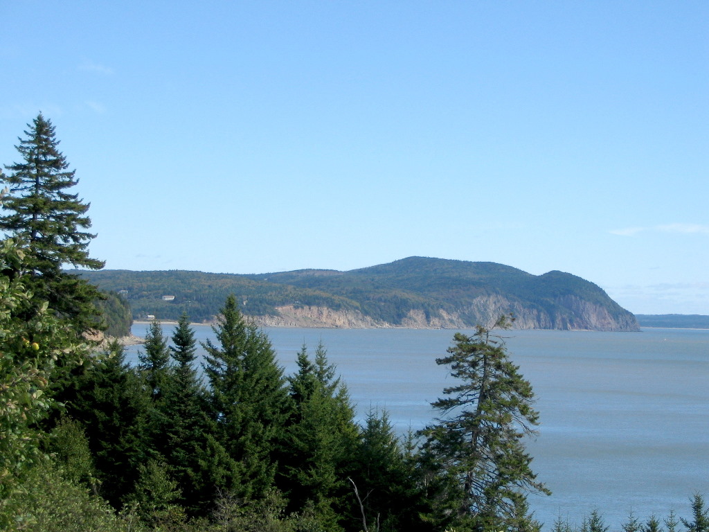
Cape Enrage About 10 miles up the coast from Fundy National Park, Cape Enrage juts into the bay. Cape Enrage with it's historic lighthouse is a very rugged point of land extending into the upper Bay of Fundy where Nova Scotia lies only 5 miles across the bay. The name "Enrage" comes from the turbulent water which washes over shoals extending almost a mile off shore from the cape. The original lighthouse was built in the 1840s and was one the earliest built in New Brunswick. The current structure dates from 1870s.
As usual, there is sparse signage to this area and the 5 mile drive from the hiway on secondary roads takes you up and over a number of estuaries and
heights of land before you arrive at the light house.
Technically the end of the cape is an island but the road serves as a causeway which connects it to the mainland. This out of the way spot is well worth finding. The light house keeper's house was saved from demolition by a local group which involved a teacher and students from the local high school. Extensive volunteer work by these young folks has resulted in a well kept structure which serves as an interpretive center.
The project includes an active rock climbing area nearby, which provides instruction and which generates a small amount of money to supprt
scholarships for the local high school.
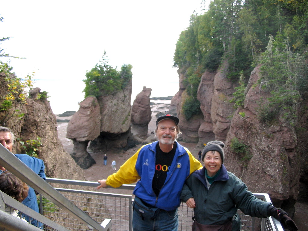
The Hopewell Rocks
The last stop on the day's tour was further up the coast to
The Hopewell Rocks.
This is an area where dozen's of "Foowerpot Rocks" stand along the
beach just off of the cliffs. Thew cliffs are perhaps 75 - 100 feet high alnong this section but the tides are over 40 feet from low to high. So at low
tide (which is when we were there, you will see a muddy beach bordered by sheer cliffs, and at high tide you just see the water 40 or 50
feet down from the edge (see photo).
There is a long stairway which I went down which is mostly submerged at high tide.
So what is a "Flowerpot Rock"? The pictures below and in the album will give you a good idea. Simply put, these are rock formations which are just off from the cliff face along the beach. The are typically tall formations of the same rock as the cliff. The action of the tides over the years has eroded the softer rock and washed it away. Those sections of harder rock scattered throughout the area managed to resist the tidal erosion and now stand isolated on the tidal flat at some distance from the cliff. Another way to say iot is that the cliff has been continuously erodeded away and pushed back by the tides and a few harder sections were left behind. These too will eventually fall away as you can see some of are being perilously undercut. This is a natural phenomenon which arises from the combination of very strong tides, high cliffs along the shore, and differential hardness of the rock. Since most of these rocks have trees or other vegetation still growing on the top, the name "Flowerpot" is quite apt.
The walk from the visitor's center to the stairway is fairly long (maybe 3/4 mile) but there is a shuttle bus. The stairway is also quite a climb (probably 100 vertical feet) - but sorry, there is no elevator. I climbed down and spent at least half an hour wandering in and around and in some case under these formations. It's really other-worldly and as far as I know totally unique. We also spent some time in the visitors center. Like the other similar centers we visited this week, it is well staffed, totally non-comercial and had very helpful exhibits, films, and other educational material. Of special note was a time lapse photo of the tides coming in and out around the Flowerpot Rocks. It was quite impressive.
Since the day was getting late, we reluctantly started back to Saint John. Instead of retracing our steps, we continued on the highway up
to Moncton and then got on the major road that headed back to the southwest, and in about an hour or hour and a half from Moncton we
were in Saint John. Since it was getting dark and we were tired, we went back to the Reversing Falls Restaurant - this time the slightly
more uppscale dinner place - and had a nice final dinner in Saint John. Tomorrow we would head back to the US after a great time spent in
New Brunswick.
Interactive map of today's journey:
Map Album of today's photos: Album Tuesday, September 25th - Back to the US - Bar Harbor, ME
his was the day when we would leave Canada and return to the US. We weren't sure about the possibility of driving all the way back to the Boston area so we left our destination for tonight open. We talked it over and decide we would head for Bar Harbor, where we could expect plenty of available places to stay, and we would try to pick up a couple of survey markers that were more-or-less on the way.
Seriously, the exchange
rate between the US and Canada had dropped to parity for the first time in decades. That meant that prices of goods in the US were cheaper in
Canadian dollaors, and everyone and his sister was driving across to Maine to stock up on bargains. The wait to get over the bridge and
through US Customs was close to 1/2 hour - unusual for the small crossing. We finally got to US Customs and I answered the usual questions:
"Any alcohol?" No, "Any guns?" No, "Did you have a good time?" No - Oops , I mean yes! Then off we went, free citizens.
There were two old survey markers on the way to Bar Harbor. or at least not too out-of-the-way. There was station "Rye" on Rye Hill,
off of Route 9 about 12 miles from Calais, and station "Cooper" on Cooper Hill (perceptive readers will notice a pattern in these names
Well, the results were like night and day: Rye was a miserable bushwhack through brambles and nothing was found, Cooper was a drive up and the
mark practically jump out at me. Read the reports below for details
(Rye; Cooper).
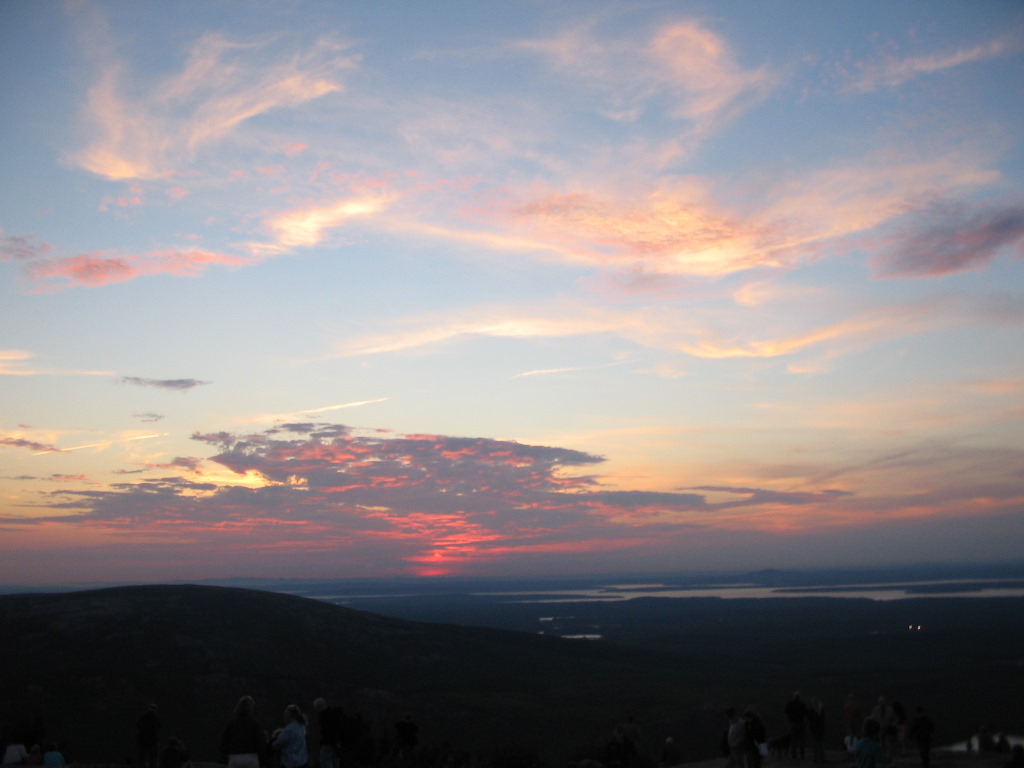
After bagging Cooper, it was off to Bar Harbor. We took Route 191 down to Route 1 and then south on Route 1 to Ellsworth. Of course we passed through much of the area we had visited the week before. We actually stopped for lunch in one of the spots in Machias that we had liked when we were there before. This coastal drive from downeast Maine to Ellsworth passes through a number of very pretty areas, but as you get close to Ellsworth the culture changes to a more commercial, tourist centric area. Bar Harbor and Mount Desert Island are gems, but you can keep Ellsworth. We eventuallly got through the traffic and the strip malls and crossed the causeway to MDI. We stopped at the tourist bureau just across the causway and found out that there were literally dozens of motels, hotels and B&Bs with vacancies. The B&Bs were much pricietr than the Motels so we picked one (The Edenbrook) that I was familiar with (just across from the College of the Atlantic - where for many tears I had attended a summer running camp.) We checked in to a clean, not too expensive room, dropped some of our stuff, and headed for the top of Cadillac Mountain hoping to see the sunset.
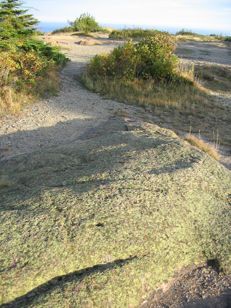
There was a good crowd up there (it's a drive up) but not horrendous. I got away from the throngs briefly to check out the highest part of the peak (behind the souvenier shop) where no one, but no one was around. Since this is 200 yards or so from the parking lot, no one had bothered to walk up. I found 4 survey disks (to be precise: 1 bench mark, 1 triangulation station and 2 reference marks). The tri-station was - you guessed it - one of my target markers. Originally a simple hole in the rock was drilled in 1856 and a disk was set in this hole in 1931,
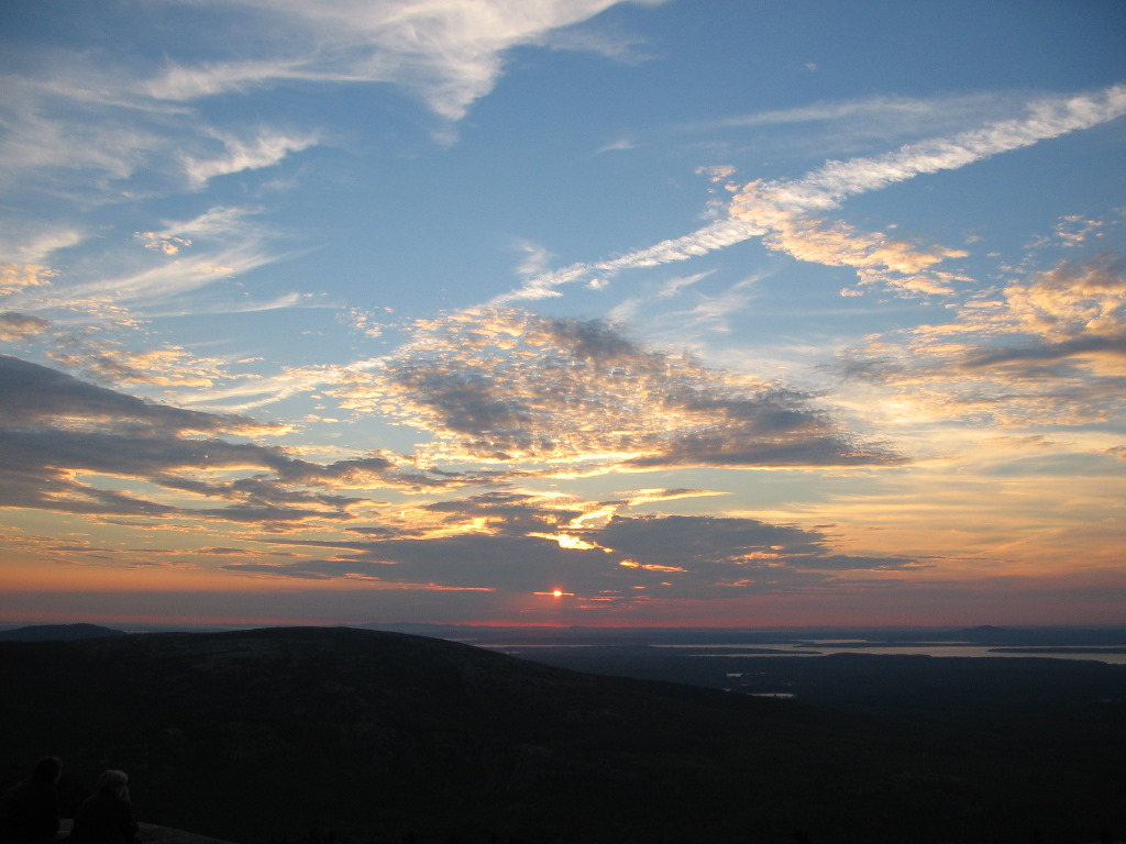
preserving the exact location. The 2 reference marks point to the tri-station and the bench mark was set by another government agency (the USGS) in 1934, and is unrelated to the 1856 station. The mountain was called "Green Mountain" in 1856 but the station "Mount Desert" was named for the Island, not the mountain. There's a report below: Mount Desert Reset. The "Reset" means they put a disk in the original drill hole. Joy and I walked around a bit and took in some of the wonderful views. Then we got back in the car and drove a short distance down the mountain to a viewing area that faced in just the right direction for the impending sunset. We were not the only ones with this idea - by the time we found just-the-right spot to sit, there were probably a couple of dozen others there doing the same thing. Everyone chatted quietly and thoroughly enjoyed the ever better picture laid out before us in the sky. It was really quite beautiful.
Finally, the sun made the final passage from day to night and at that moment, a spontaneous round of applause broke out from the crowd watching the
spectacle.
With that, we reluctantly left the show and drove down the winding road (with lots of company) and made our way to Bar Harbor. We had an great dinner at the Quarter Deck Restaurant (including a great local microbrew). We then walked up the street for some ice cream (a must for visitors to Bar Harbor), and got back to our motel for a well deserved night's sleep. The next day we would return to New York City via Boston. It was one of our best vacations in years.
Interactive map of today's journey:
Map Album of today's photos: Album
|
Benchmark Hunting in Downeast Maine and nearby areas of Canada
o what exactly is a "benchmark"? A slightly better term would be "survey marker". These are usually brass disks about 3 inches in diameter (see photo, left) which are placed by government agencies or sometimes private firms and indicate a point whose exact elevation or position is
The popular name for all of these is "Benchmark". But like any technical subject, the deeper you look into it, the more complicated it becomes, and the more and more distinctions you will find among the uses and names of these markers. But I'll try to keep it simple. Many (but not all) of these markers are indexed by the US Government in an on line database, and this is where I go to find what's out there. Of course professional surveyors and various agencies use this index for their own use, but a "benchmark hunter" uses it to try to find some of these markers just for the fun of it. The 6 digit IDs that you see in the table below, and in the reports, are indeses to this government database. My benchmark hunting had to be interspersed with the touring we planned to do through this beautiful area, so I had to be selective in what I went to look for (after all this was a vacation first, and a benchmark-hunting trip second). I decided to go after two sorts of survey markers: boundary markers (also called boundary monuments) of various sorts (after all, our trip took us along both sides of the boundary between the US and Canadia), and survey markers which where part of the original survey done of the area by the U.S. Coast Survey in the 19th century. A surprising number of these old markers still survive in this area.
There is a web site devoted to the hobby of benchmark hunting (there's always a web site!
Use the index below to go to a particluar report:
The first accurate survey of the East Coast of the US (1830 - 1898): The Eastern Oblique Arc
he Eastern Oblique Arc. So what exactly is that? In simplest terms the Eastern Oblique Arc (EOA) was a set of surveys done along the East Coast of the US in the 19th Century. The survey consisted of "stations" (markers which were set and measured by surveyors), usually on mountain or hill tops and measuring the angles from each stations to all the nearby stations. The stations all had permanent markers, which in those days were typically a copper plug mounted in a rocky ledge, or sometimes just a hole drilled in the rock. The name of the station was usually the name of the place where they were set (like "Cooper" which was set on Cooper Hill), but occasionally other names were made up. The locations of the whole set of markers was determined using "triangulation" which is a fancy word meaning they used the rules you learned in high school about triangles (such as the sum of the 3 angles must add up to 180° - remember? ). So with this math (called trigonometry),
they "solved" all the triangles: from a known starting point together with a measurement of the length of one of the legs, they calculated
where every station was located. Because of the large number of stations and hence the large number of triangles formed, this was a fairly extensive set
of calculations. In the pre-computer days when this was first done, it literally took years of work by teams of mathemeticians. (Ironically,
the people who did these types of calculations were called "computers".)
Now think of doing that down the entire East Coast. Oops! Problem! Because of the curvature of the Earth, high school math will no longer suffice. We have to get into spherical and ellipsoidal trigonometry. That's tough stuff. and consumed many man- (and woman-) years of work.
To visualize what we're talking about, let's start with a map. Holograph, a fellow member of the Groundspeak Forums, has an excellent web site
explaining this. Here's Holograph's Web site:
The Eastern Oblique Arc. And here's Holograph's map of the area in Maine where I was doing my benchmark hunting:
And if you're interested in the complete 394 page report published in 1902 by the U.S. Coast and Geodetic Survey, here it is: U.S. Coast and Geodetic Survey Special Publication No. 7 (1902) Note, that the section of the survey shown in the above map was just the first, northeasternmost section. It consisted of 8 primary stations (and numerous secondary stations, not shown). The entire Eastern Oblique Arc survey spanned 17 states from the northeasternmost part of the US in Maine, down the coast, across the Appalachian Mountains in Georgia and ended up in New Orelans. It consisted of 20 sections and (if I counted right) 204 primary stations. Here's a map of the whole thing from Holograph's Web site: Complete Map of EOA. The first stations (in the Mid Atlantic states) were established in the 1830s and the last ones (in 1898) were established in New Orleans. It was a mammoth undertaking involving literally years of computations, and was the first time an accurate measure of the shape of the surface of the earth (called the "figure of the earth") was determined.But my vacation time didn't allow a trip from Maine to New Orleans, so this first section in Maine (with a few stations in Canada) was what I would I spend my time on for this trip. The idea for actually searching for survey markers which were part of the Eastern Oblique Arc came to me just a week or so before the trip when it came up in a discussion on the Benchmark Forum about depicting triangulation schemes on maps. I was introduced to Holograph's excellent site on this 19th century triangulation. When looking at the maps, I realized 1) the area in eastern Maine would be right where our travels would take us and 2) many of these stations are still in existence. So of course the plan was "Go get 'em!". I had to rule out three: "Grand Manan" (on Grand Manan Island, Canada, in the Bay of Fundy, off the coast of Maine), "St. David" (in Canada, reported lost in 1887) and "Prince Regents Redoubt" (in Eastport, reported lost in 1910). That left 6 primary stations. To these 6, I added 2 more: "Quoddy", which was in the secondary scheme, and "Mount Desert", which we would visit on our last day (besides, this frequently-logged mark on Cadillac Mountain was a "Gimme"). All but Mount Desert had the original marks, although two (Calais Observatory and Howard) were believed to be lost. I visted them as well just to "make sure". Here is the list of the stations I visited (in order of searches):
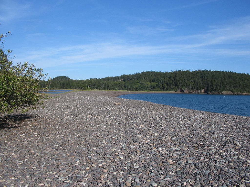
Trescott Rock - found - PD0894
The link at the end of each line in the list is the Permanent ID (PID) set up by the government, and these links will bring you to my report
for the station below. 5 markers founds out of 6 findable marks is pretty darn good, if I do say so myself. What to do
next? Go back of course, get 'em all! Anyone wanna come?
TRESCOTT ROCK (1861) - Found - PD0894
his one was on a hill now known as "The Porcupine" which no one in the area had ever heard of. Finally someone told us "Oh, that's on Wayne Jones' Road". This seemed to be the same road described in the 1960 NGS log:
When I got back to the car, there was my wife talking to Wayne Jones himself, a hard working lobsterman who owned "this side" of the mountain. He
was surrounded by various children, in-laws and grand-children. As usual for Mainers, he was friendly and happy that I had found what I came looking
for.
HOWARD (1859) - Lost ? - PD1029
knew this one had been lost in the late 1950s when the Air Force built a radar dome over the mark, but I just wanted to "check it out" as they say. The Air Force left the site in the 80s and the top of the hill is now used as a prison, so there was no way to visit the site up close. However I'm glad I went since the original radar domes are now long gone and a radar dome of later construction is well to the south of the original station's location (see map and aerial inserts). So maybe, just maybe, the old mark is still there, perhaps under some crumbling concrete. Anyone want to get permission and check it out?
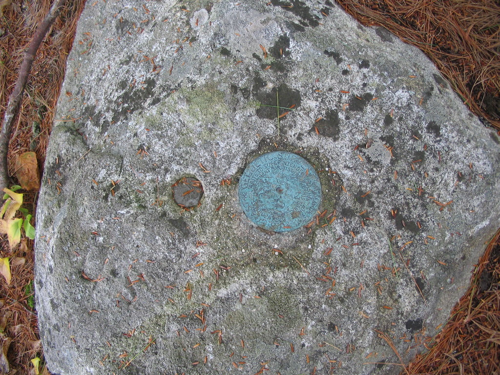
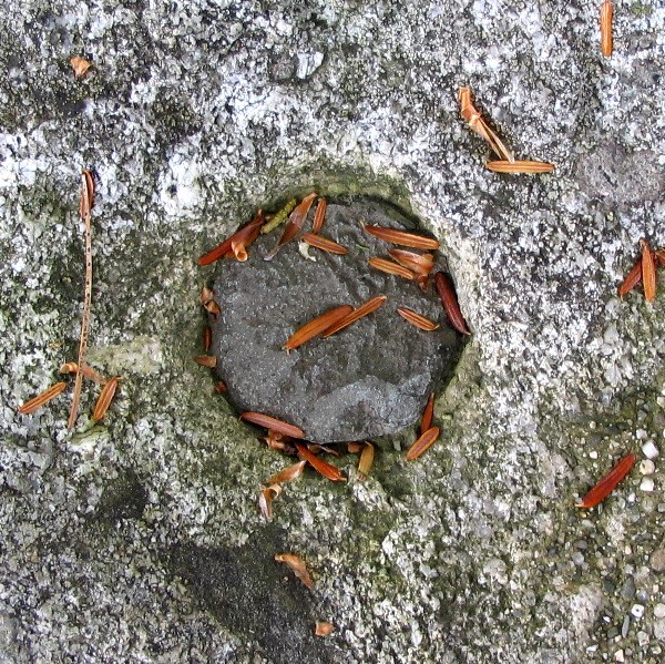
QUODDY (1860) - Found - PD0690
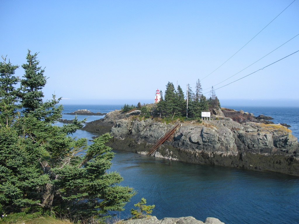
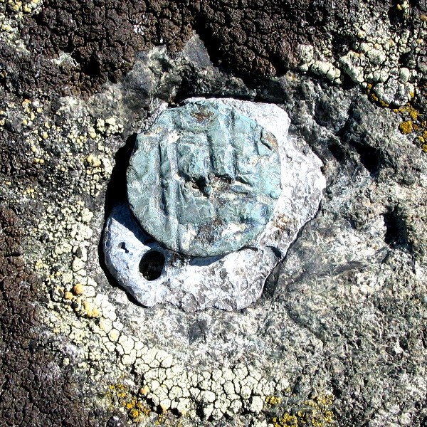
his mark is very near the Coast Guard lookout tower (PD0721) on West Quoddy Head, but is seldom visited. To reach the station, climb the gated road to the tower. When you reach the point where the road to the tower turns left, go straight into the woods and bushwhack to the high point. It is not tough going, but there is one rock ledge you must scramble over. A GPS would help. When you reach the clearing at the high point, the station will be found in the center of a small ring of rocks (see photo). This is fortunate, since the area is covered by a thick layer of moss and lichen and a good bit of digging would be needed to find the station if it were not so marked. The copper bolt is in good condition, with a large punch hole in its center. The two reference marks (set in 1913 and 1960) were also found in good condition.
This station was not in the primary scheme for the Eastern Oblique Arc, but was one of the many secondary stations set in the 1850s and 1860s. As
luck would have it, we parked at the old Coast Guard Station (now a lodging) and in the office, an old chart showing the Coast Survey triangulation
of the area was sitting on the wall. The owner is a history buff! What a coincidence.
CALAIS OBSERVATORY 1866 - Lost - QF0763
knew this mark was lost, but I visited the site anyway as I was passing through since it was important both as a primary station in the Eastern Oblique Arc and as a point important in establishing accurate longitude in North America. See this link for an account of the setting of the commemorative disk at the site by NOAA in 2005: NOAA Web Site To quote from that web site: On December 16, 1866, the Calais Observatory marked the final piece of the first successful transatlantic telegraphic longitude determination. This was a tremendous advance for the transfer of accurate time across the Atlantic Ocean. It provided for the precise determination of longitude at the Harvard Observatory in Massachusetts, relative to Britain's Greenwich Observatory ...
Interestingly, when I asked at the Tourist Information Office for directions to the old Calais Observatory, the woman had never heard of it even
though she had lived there all her life. After finding the station and taking my photos, I returned to tell her. She recalled a group had come about
two years before and did some sort of dedication. They renamed the vacant lot "Meridian Park", but the name, and the visit has quickly disappeared
from local knowledge. Now it's just "That pile of rocks behind the nursing home".
CHAMCOCK (1857) - Found - QF0683
his mark especially intrigued me since 1) it was a primary station of the Eastern Oblique Arc, 2) it was in Canada and therefore 3) it is seldom visited by US benchmark hunters. It was just by luck that the Deer Island Ferry was not running which necessitated us driving up to the Calais border crossing and spending the night at Saint Andrews by the Sea. A lovely little town in a beautiful spot at the head of Passamaquoddy Bay. There is an old road the leaves from behind the Rossmount Inn, a very expensive restaurant and Inn, and leads right to the summit. So there was no trouble whatsoever in getting to the location of Chamcook. Finding the mark was something else. After reaching the summit clearing, I checked the rock ledge at the highest point, and immediately found a drill hole. This is RM1 (there used to be a disk set in the hole). This is an important starting point. The next thing I did was to inspect the ledge around the high point. I soon found a copper plug NW of RM1 (towards the picnic table). I checked carefully and it was stamped 091006 which according to the 1985 recovery was RM5. This was a bit of a puzzlement. After speaking to someone who was in the 1985 party, I think this may actually have been RM6 as the stamping would imply. Now with two marks and some bearings from the NGS log I went in search of the station. There was a distance for RM1 but not for RM5 so it took a few false starts to get the right area. I used both compass and GPS to get bearings to the station. After a bit of digging and checking bearings, I realized the station was behind a couple of small trees in another small clearing. Everything in this spot was covered by moss and dirt so it took quite a while to scrape it away and search. Finally I found one drill hole, and then a second one. The log said the station had 4 drill holes around the copper plug, so with an assumption as to which side I was on, I zeroed in on the station. Finally I found it, cleverly hidden in a square depression about 3 inches deep covered by dirt and moss. The depression was probably carved out for the mark. Eventually I found a third drill hole, but not the 4th.
This find was one of the most rewarding for me, especially since it was so far from the beaten path, and that it was the original 1857 mark from the
primary scheme of the EOA.
RYE 1867 - Not Found - QF0932
his station was a copper bolt set in the rock in 1867 and recovered in 1908, 1935 and 1963. The 1963 recovery log was as follows:
So I decided to try to follow these 1963 directions. I followed Route 9 for 3.0 miles from the Route 1 & 9 intersection. Unfortunately, the house with the mailbox of M. Brownlee, was long gone. So I drove the remaining .4 miles and looked around. The GPS was now pointing close to perpendicular to the highway, so I knew I was as close as the highway would take me. At this point, Route 9 must have been relocated some years back and the old right of way (to the north) rejoined the present highway right where an old road went into the woods. I figured this must be the "Grassy Road" from the 1963 description, and so I parked the car on the highway margin and got going. The GPS said .8 miles to the mark. I followed this road for about .2 miles where it petered out at a boggy clearing. A faint inntermittant pathway headed off in mostly the wrong direction. So much for the 1963 directions: it was a cross country bushwhack from here on following the lead of my GPS. The going was bad. Trashy 3rd growth forest interspersed with clearings that were overrun with near impenetrable blackberry patches with thorns. I slowly and painfully made my way around the worst sections and through obstacles till I got about .2 miles from the top. Suddenly I found a road which helped me make a little progress upward but it soon went off in its own direction and I was left to my own navigation skills once again. At long last I reached a clearing near the summit and my GPS beeped and cheerfully said "Arriving at QF0932". Would that it were so! The clearing was overrun with thorns, rocks every which way in piles large and small and no apparent open ledges (need I mention there was no witness sign nailed to a tree). Every pile of rocks was on top of more rocks as far as I could dig. After about 30 minutes of this (did I mentioned this was the one and only hot and buggy day of our vacation) I gave it up. I had set a waypoint at the car, a good thing, since this featureless place would be an easy (but nasty) place to get lost in. I used that old road to save some of the worst bushwhacking going down, but alas it too decided to go off who knows where, so I ended up bushwhacking back most of the way back.
A disappointing trek. Tough going both up and down with no reward. Some days are like that.
COOPER=WESTERN RIDGE (1859) - Found - PD1041
till smarting from my experience on Rye Hill, we drove back to Route 1 and went down Maine Route 191 about 10 miles to Cooper Hill. My DeLorme gazetteer showed a short dirt road up the hill labeled "Tower Road". Sounded good. When we got there, we found Tower Road was easily drivable and when I pulled in next to the lookout tower I could actually see the mark without getting out of the car! What a contrast: Rye with .6 miles of brambles and no mark; Cooper a drive up with the mark literally jumping out to greet you.
I was happy to get Cooper. It was a veritable hub for the triangulation of eastern Maine. One slip up: I searched in vain for the two reference
marks. The distances from the station were given on the datasheet, but no bearings or directions. It wasn't till I got to Bar Harbor that I realized
that Cooper RM1 had it's own PID with directions, accurate latitude and longitude (i.e. it was GPSable), everything (including directions to find
RM2)! And I had actually printed out that datasheet but neglected to look at it when I was up there! Duh!
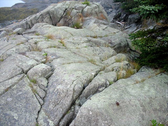
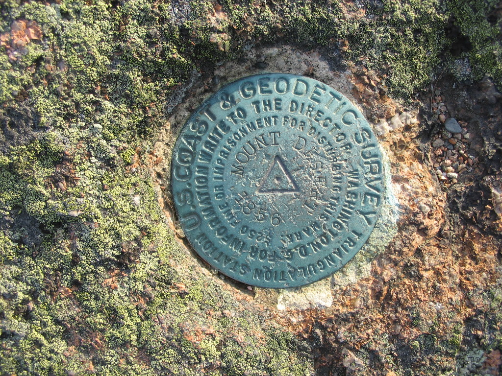
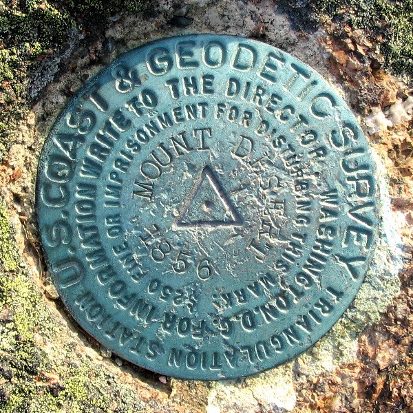
MOUNT DESERT RESET (1856, 1931) - Found - PE1778
adillac Mountain, on which this station is located, at 1530', is the highest point on the Eastern Seaboard (within 25 miles of the coast). It also has the distinction of being the first place to see the sunrise in the lower 48 states from early October to early March each year when the sun is in the south. This Station is a "Gimme": one that is often logged and easy to get to. Today we blythly drive to a mark such as this and (when we're lucky) walk right up to clearly marked station disk. "Cooper" (previous report) was like that - although it is so out of the way that no one bothers to go and look for it. It's easy to forget that when this station was set up in 1856, there was no road to the top of the mountain, and probably few roads on the whole island, with perhaps a ferry to Bar Harbor. The Island was inhabited by scattered farms, timber operations and fishing villages. A team of surveyors set a drill hole on the rock with 16 other drill holes (called range holes) arrayed around the first one in pairs, pointing towards other stations in Eastern Maine. Over the the next several years, surveyors would return and make measurements of azimuth (angles) to the other stations with precision equipment. For the best sighting, these measurements were done at night, while teams on those other stations kept lights burning to mark the stations being observed. The head of the party in 1856 was none other than Alexander D. Bache, the Superintendent of the Coast Survey. Today it would be astonishing if the head of a government agency was out in the field doing the front line work. But there he was: in station after station from the 1850s and 60s all along the East Coast we see the initials A.D.B. on these projects.
Fast forward: 75 years later - it's 1931 ...
Perhaps due to a dearth of new undertakings in that economically depressed time, he spent 3 summers on this mountain searching out and measuring
as many of the long forgotten drill holes as possible, finding all but one of them - all this to verify that the one central hole was the station
from 1856. We can imagine the summit in these pre-tourist, pre-auto road days as a barren place of rock ledges, lichen, moss and brush, visited
only by the occasional hiker. What he did boggles the mind, especially in light of today's overworked, understaffed situation.
Here are the logs from the 1930s when this station was rediscovered, remarked and verified:
Others were busy in the 1930s as well. In 1934, the United States Geological Survey (USGS) ran a level line from the Post Office in Bar Harbor to the top of Cadillac Mountain (and continued around all of Mount Desert Island). The USGS disk on the highest point of the mountain bears witness to this project.
Fast forward again: 76 years later - it's 2007 ...
A great way to end a great vacation.
The Boundary between the United States and Canada
Boundary Markers
oundary Markers, or Boundary Monuments as they are usually called, mark actual points on the boundary line - which consists of a series of straight line segments conecting one monument to the next. By their very nature, these boundary markers or monuments are survey markers, and their position and elevation is measured just like any other survey marker. However, since the boundary line in this area goes down the middle of the Saint Croix River, and through Passamaquoddy Bay, there are, strictly speaking, no boundary monuments here, since you can't stick a monument in the middle of the bay. Nevertheless the surveyors - as well as the lawyers, politicians and diplomats who are concerned with the boundary, insist that the line be precisely specified in relation to some sort of permanent markers on the ground. To accomplish this, several strategies were employed. Passamaquody Bay: Range Marks
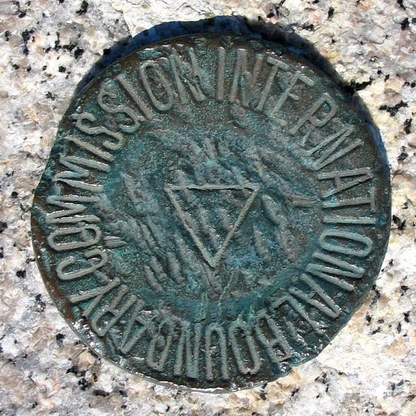
Most of the original Range Marks were put into place in 1919 when the boundary line through the bay was surveyed. Some of the original concrete markers have been replaced over the years, generally with tall triangular shaped steel structures (see image right). The Saint Croix River: Reference Monuments Compared with the 13 Turning Points in Passamaquoddy Bay (plus a few in the Bay of Fundy),
Unfortunately I was only able to find one of these Reference Monuments, and that was broken off with only the shank remaining (see image right). But to a surveyor, the shank of a monument is sufficient, so this station is still valid and usable. I tried to find the first one at the mouth of the river (No. 246) but I misread the paperwork and missed it. I suspect it is still there on the shore of the river in Robbinston, Maine. Maybe some day I'll get back to this area to search for it again. Tying it all together: Triangulation and Traverse Stations The last types of boundary markers used in this area are Triangulation and Traverse Stations. These serve the same function as they do in any survey, namely to mark a pricise location (the latitude and lungitude) of the point. The process of tirangulation, such as used in the Eastern Oblique Arc described above, provides the maximum accuracy using classic surveying techniques (prior to the use of precision GPS). Doing a traverse survey simply means working from one point to the next, rather than measuring each point in relation to many others. A traverse survey is less accurate, but may be the only way to do a survey with many points in a line such as a boundary. The other important thing that using Triangulation Stations provides is "control". Control means connecting a local survey to a known (previously defined) network of stations,
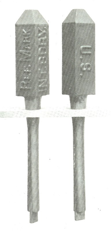
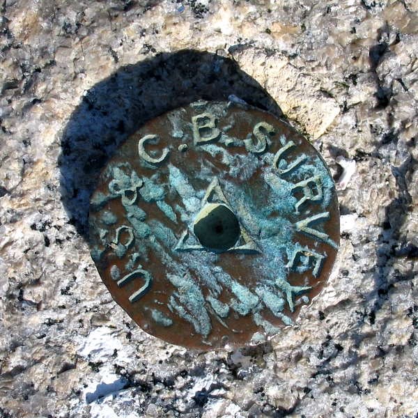
I have no example of Traverse Stations, but two types of Triangulation Stations were found: the old style US&CBS (United States & Canada Boundary Survey)
triangulation disks (about 2 inches in diameter) which were set near the border from about 1912 to 1925 (see image left), and the more modern type of
IBC disk (about 3 inches in diameter) which are similar in size to those used by other agencies (see image right).
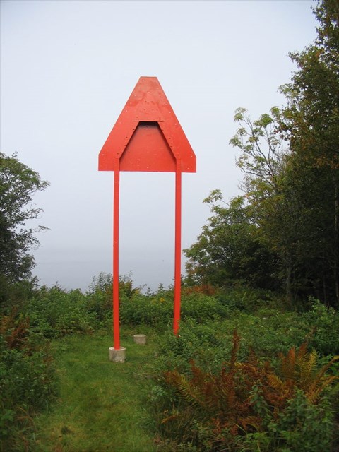
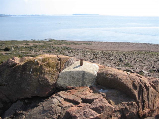
RANGE MARK 41 IBC 1919 - Found - PD0692
|
 (Click on the picture for a larger image)
The two markers lined up pointing to the course of the boundary out in the Bay
|
| T |
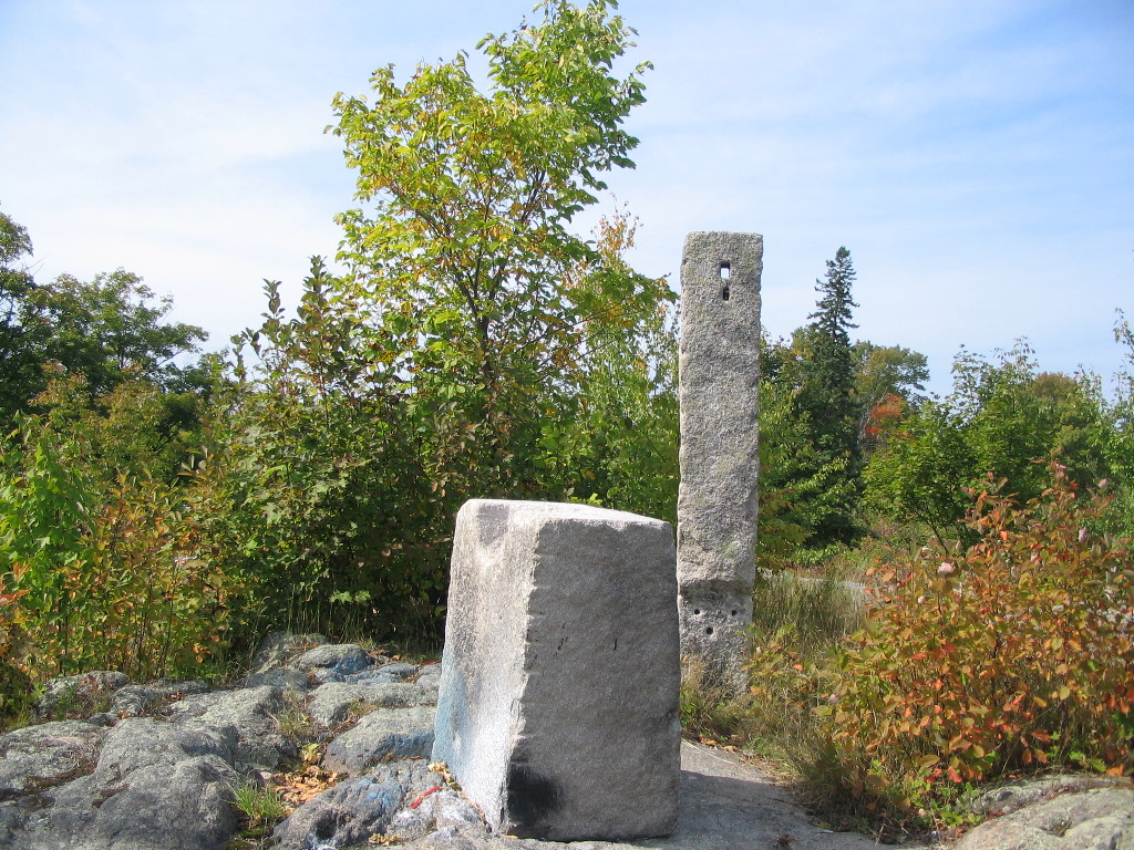
After visiting the West Quoddy Head Lighthouse, we made a stop along the road to find a pair of these things. I tramped through the woods at just the right point and lo and behold about a 100 yards into the woods, there they were. This particular pair is the easternmost pair on the US side of the line and "range" course 11-12 of the boundary.
I had no idea what these things looked like till I got there. The most surprising thing was how big they were! The original markers were large concrete pyramids about 6 feet high. Many of the old concrete pyramids were replaced in the 1970s by tall steel triangles (about 10 feet high) painted red-orange mounted on two steel legs. In the middle between the legs right under the point of the triangle was a concrete piling with a disk which marked the spot of the original marker. I guess we would call this a reset. A red-orange steel triangle has been attached to the front of the concrete pyramid (probably this was done when the steel triangles were built) with a hole cut to show the original 1919 bronze plaque.
This pair was interesting in that the rear marker was one of the old concrete pyramids, and the forward marker was one of the newer steel ones. As the picture shows, the line between the rear and front markers has been cleared so they must still use these things.
When you look in the right places, you'll see many of these Range Marks on both the US and the Canadian side of Passamaquoddy Bay. We managed to
find 10 of them and check them out up close.
 (Click on the picture for a larger image)
View of the Lubec breakwater, the Range Mark and Mulholland Point Light (on Campobello Island) beyond
|
| A |
There was an old breakwater jutting out from the shore into the channel. It takes a turn about half way out, and there sitting on the breakwater was a minuture version of a Range Mark. It was an old marker set nearly a century ago, but evidently due to the fact that it was sitting out on the breakwater, it was constructed only about 4 feet high. It turns out that ice had moved the breakwater rocks over the years, so this and a couple of nearby triangulation stations had to be resurveyed in the 1960s and realigned. This marker, paired with one of the steel triangles at the shore range course 7-8 of the boundary.
We found altogether 3 stations out on the breakwater. Besides the Range Mark (number 27) there were two triangulation stations: Lubec Tablet and Breakwater 3, plus a reference marker for Lubec Tablet. Like the Range Mark, they had also been resurveyed. Breakwater 3 is actually an original IBC triangualtion station disk set by the IBC in 1913. But winter ice has repeatedly moved the massive rocxk on the breakwater, so it was resurveyed in 1919 and renamed Breakwater 2, It was again moved by the ice several more times and finally in 1961 was resurveyed again and it became Breakwater 3. But it's still the oringinal 1913 bronze disk, having now served as a marker for three separate geodetic locations (with 3 different names).
The other Triangulation Station is Lubec Tablet. It is a larger IBC disk set in 1961 (they were busy that year) and is just beyond the Range Mark. And sitting on top of the Range Mark is an IBC Reference disk which points to Lubec Tablet.
Three stations and a Reference Mark! Not bad for a lunch break. And the clam chowder was great!
 (Click on the picture for a larger image)
The rock ledge at Cranberry Point The marker is visible just left of center
|
| O |
On Cranberry Point, a point of land about a half mile south of the bridge, there are a couple of triangulation stations. We first parked near the wrong point, and I obviously had no luck finding the marks, then I checked the map and my GPS again and found a spot to park near a Range Mark, and from there it was only a 10 minute walk along the shore. Unlike the previous afternoon, it was very foggy, so we could barely see the lighthouse just off the point, and we could not see across to the US side at all.
Station "Cranberry Point IBC" was easily found on a rocky point. It's an old style IBC disk (rather worn) set in 1913, so it was a rather good find. There was also a Canadian triangulation station nearby which we found as well.
The other IBC station, "Cranberry Point Drill Hole IBC" was not so easy. I measured off the distance from the first station and although there were
several drill holes on the rocks, none was in the right place, so this one remains a "Not Found". You win some, you lose some.


 (Click on the picture for a larger image)
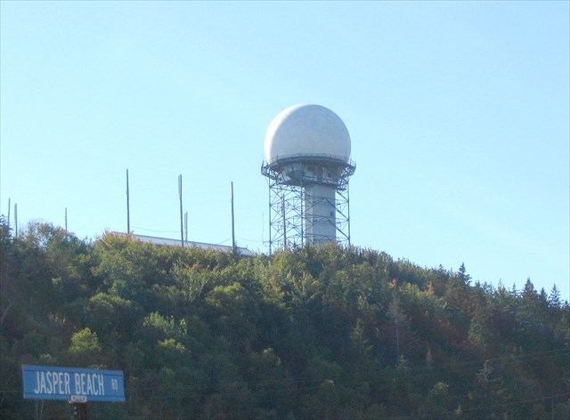 (Click on the picture for a larger image)
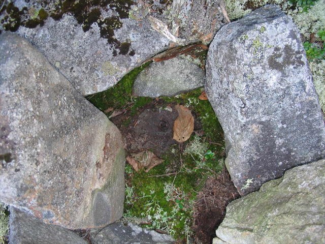 (Click on the picture for a larger image)
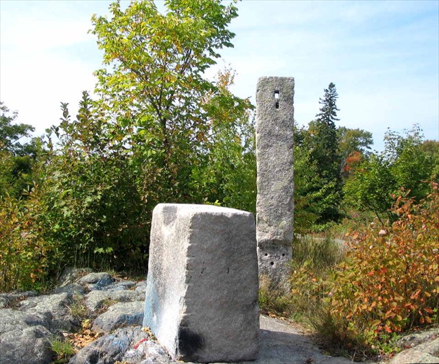 (Click on the picture for a larger image)
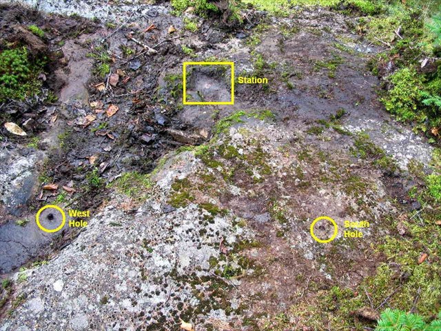 (Click on the picture for a larger image)
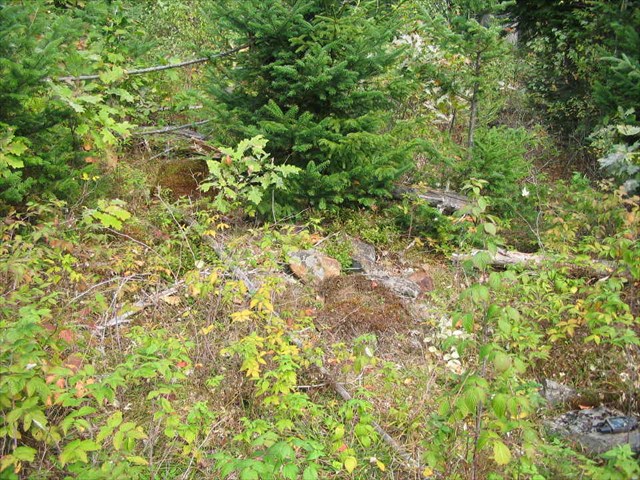 (Click on the picture for a larger image)
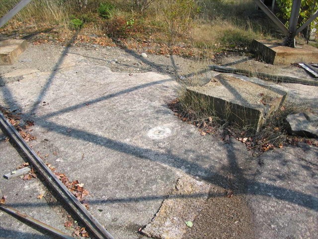 (Click on the picture for a larger image)
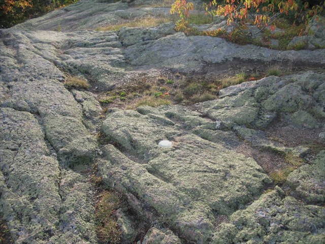 (Click on the picture for a larger image)
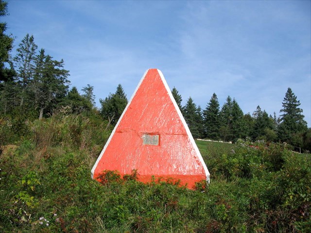
 (Click on the picture for a larger image)