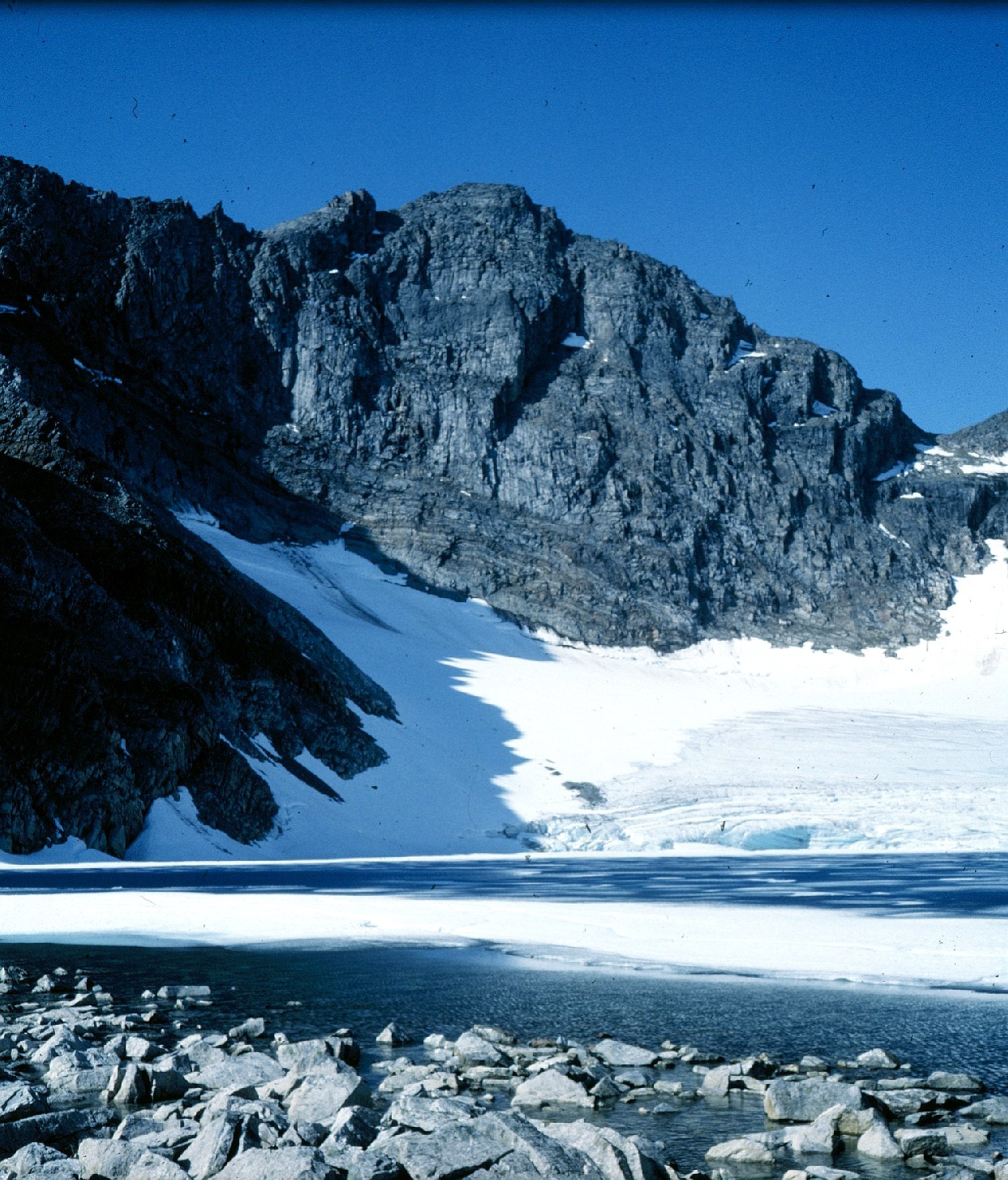
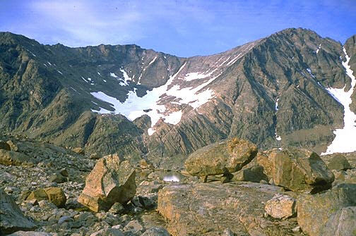
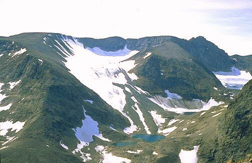
Mount Caubvick/Mont d'Iberville from Ice-blue Tarn
Photo: Hazen Russell, Iapetus Ocean Expeditions (1982)
Click on this or any image for a large version
|
Mount Caubvick/Mont d'Iberville from Ice-blue Tarn Photo: Hazen Russell, Iapetus Ocean Expeditions (1982) Click on this or any image for a large version |
|
Click here for an album of photos of the Torngats |
| T |
The descriptions and lists on this page includes the Kaumajet Mountains (Kaumajet means "shining-top" in the Inuit language), which is a small range on the coast near Cape Mugford and the Kiglapait Mountains (which means "sierra" or "saw-tooth"), another coastal range near the village of Nain.
I'm known in the hiking community as "Papa Bear" (also know in real life as Richard) and I hope to explore this remote area in the near future, and I have begun to collect all the information I can on the area, including accessibility, terrain, mountains, rivers, etc. This page is a way for me to organize this information and to make it available to others who may be interested.
The information on this page is from varied sources, largely from the internet, and is as accurate as I could make it. I would like to especially thank Hazen Russell, Jack Bennett, John Stix and Stephen Loutrel for many nuggets of information. They have all "been there, done that". There is no substitute for first hand information and I am grateful for their help in answering my many questions. Secondly I owe a great debt of gratitude to Greg Slayden who, together with myself (and working largely from rather poor on-line maps of the region) built the basic peak database that I relied on for my peak lists.
I hope you find this page informative, and furthermore that you may be inspired to find your way up there some time in the future. Any and all information or questions you have are more than welcome. In particular if you have any information or links to internet resources on this region that I have missed, please let me know.
| Just click here to send me a note. |
|
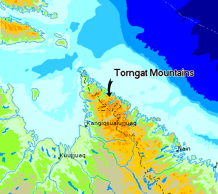
The Torngat Mountains of Northern Labrador and Quebec Click on an entry to jump to a particular section: | |
Geography and Geology of the Torngats
|
This section is under construction. Any good references would be welcome.
http://sts.gsc.nrcan.gc.ca/clf/landscapes_newfoundland.asp
http://www.nationalgeographic.com/wildworld/profiles/terrestrial/na/na1118.html
http://collection.nlc-bnc.ca/100/200/301/ic/can_digital_collections/parks_atlas/chap24/REGION24.html
http://www.aina.ucalgary.ca/astis/
 Northern Labrador and Quebec Map: Atlas of Canada |
| M |
Paper maps of the Torngats are available in the regular 1:50,000 Canadian NTS series. These maps were made from photometric images from the 1960s, and were produced in the mid 1970s. The contour interval is 100' and the Datum used is NAD27 Canada. They are available for the entire area and they suffice for most hiking and climbing purposes. One nice thing about the Canadian maps that I wish US maps had, is a UTM grid overlay. Every 1000m square is laid out with the appropriate UTM coordinates. This makes finding locations and UTM way points much easier than on a US map. See below for more on UTM notation. I found a good source for ordering copies to be Map Town, Ltd of Calgary. I ordered mine on-line and they arrived in less than a week.
As a help in finding which map you may need, I have included a column for the NTS map number in the peak listings below on this page. The area where most of the most popular peaks are found (if you can call one or two groups visiting per year "popular") is NTS map #14L13. This includes the entire Selamiut range which includes Caubvick/d'Iberville, Torngasoak and Cirque, the 3 highest peaks of the Torngats. It covers an area from just south of the Nachvak Fiord south to the headwaters of the Koroc River and from the Tallek Arm on the west past Cirque Mountain on the east, and includes 9 of the 12 5000' peaks in the Torngats. If you are doing a highpointing trip for Caubvick/d'Iberville, landing on the Koroc River gravel flats, this one map is probably all you will need.
It is my observation that the published NTS maps of the region tend to show sharp peaks and ar�tes (knife edges) as being lower than they are. I would guess equipment used to scan the aerial photos in the 1960s did not have the required resolution to show the sharpest features. For example, although its hard to make out, the topographic map has the highest contour around the Caubvick/d'Iberville peak as 5200', 200' lower than it is.
Latitude and Longitude vs. UTM notation: the locations of the peaks in the lists below is given in latitude and longitude (Datum: NAD27 Canada) giving degrees and decimal fractions thereof. Most atlases and gazatteers use latitude and longitude so this was thought to be the best choice. However, many users of GPS equipment prefer UTM coordinates, and in fact the NTS maps are very conveniently overlaid with UTM grid lines at 1000m intervals. UTM (Universal Transverse Mercator) notation uses a system that includes a "zone" for a large area (which is "20 V" for this entire region) followed by a six digit number giving the number of meters east of the zone boundary (called "easting") and a seven digit number giving the number of meters north of the zone boundary (called "northing"). For example, the full UTM location of Mount Caubvick/Mont d'Iberville is 20V 459054 6527522. This is accutate to 1m (much more accurate than the map). You can use your GPS to make the conversion from Lat/Long to UTM, but I have found a very useful on-line conversion procedure which will translate between the two systems on Bivouac.com: UTM converter. To use the procedure, select "NAD27Canada" in the "Input:" box, paste in the latitude/longitude from one of the lists below (take out the space between Lat and Long) and click on "Convert". Voila!
Abbreviated UTM notation: as an aid to quickly finding locations on the NTS maps, I will often use an "abbreviated" UTM notation in giving locations. The full UTM notation as explained above is rather cumbersome. I will use an abbreviated form using just 3 digits of easting (omitting the first digit and the last 2 digits) and 3 of northing (omitting the first 2 digits and the last 2 digits). The pair of numbers in this notation is accurate to 100 meters for both east/west and north/south (probably the accuracy you could read off the map without carefully measuring it with a ruler). Thus the Caubvick/d'Iberville location becomes 591275 (591 is the abbreviated easting, 275 is the abbreviated northing). Since the first two digits of each set of three are given as labels to the grid lines on all NTS maps, it would be very quick to find this on the 14L13 map - just find "59" along the bottom and "27" along the side, trace up and find the square on the map for 59,27, and then use the last digit of each coordinate to get an approximate postion within the square. The last digits are the number of tenths of the square over and up from the lower left corner. Thus Caubvick/dIbervill is near the left side of the square (1 tenth) and half way up (5 tenths). This abbreviated UTM notation is sometimes called "military notation".
A note on the names "Mont d'Iberville" and "Mount Caubvick": the border between Quebec and Labrador has historically been defined as the watershed divide for rivers flowing east (Labrador) and those flowing west (Quebec). The highest point on this divide was unnamed untill 1971. The name "Mont d'Iberville" was given to this never-climbed mountain by the Province of Quebec in that year to honor Pierre Le Moyne d'Iberville, a 17th century French-Canadian naval hero (but no hero to the English). It was first climbed in 1973 by two American climbers. In 1977 the mountain was remeasured from the original photogrammetric images and found to be the highest mountain in the region (a distinction which first belonged to Cirque Mountain and then Torngasoak Mountain, both entirely within Labrador). In 1978 a party of climbers discovered that there was a higher point a few yards north of the watershed divide and thus entirely within Labrador. They dubbed this higher peak "L1" for Labrador #1. (Several of the climbing reports from the late 1970s use "L1" as the name of this peak.) So with the highest point in the region now known to be in Labrador, the province of Newfoundland & Labrador gave it the name "Mount Caubvick" in 1981 in honor of one of the Inuits who accompanied George Cartwright to England in 1772. So although most gazatteers refer to this as a single mountain with two alternate names, I have used the convention which is customary among climbers that d'Iberville (5419') is the high point on the divide (and the highest point in the province of Quebec) and Caubvick (5420') is the slightly higher peak entirely within Labrador (and the highest peak in the province of Newfoundland & Labrador). On this page, when I refer to the mountain as a whole, I will use the name "Caubvick/d'Iberville". When I refer to a specific peak, I will use the individual name.
Toporama maps: to get you oriented, and to give you an idea of what the on-line Toporama maps look like, here
are links to the 4 quads around the Nachvak Fiord, which I would consider the most interesting area with the highest
concentration of high prominence peaks:
Other resources from the internet: I have found a few map and geography related sites that may be of some value to you:
 The major Selamiut Peaks seen from the Minaret Ridge Panoramic photo: Chris Rush (2004) |
| Click here for an an annotated version |
The Selamiut Range, lying between Nachvak Fiord on the North, The Koroc River on the South, The Tallek Arm and Palmer River on the west and the McCormick and Stecker Rivers on the east, is in many ways the heart of the Torngats. The greatest concentraion of high peaks lie here, the provincial boundary between Newfoundland & Labrador and Quebec cuts across it, and perhaps most importantly to climbers and hikers, it has ready access both from the north (Nachvak Fiord via boat or float plane) and from the south (Koroc River gravel flats via Twin Otters). Together with the significant mountains lying east of the McCormick River (including Cirque, Cladonia, Starshape, and Quartzite) and west of the Palmer River, this area is justifiably the number one destination for those who want to get the most out of their trip to the Torngats.
The word "Selamiut" in the Inuit language means "Sky dwellers" which the natives used to refer to the northern lights (aurora borialis) which in legend were the dancing spirits of the dead.
The East: The McCormick River valley:
 The McCormick River valley Nachvak Fiord visible in the distance Photo: Geological Survey of Canada (1982) |
Access: Access to the McCormick River valley is generally via Nachvak Fiord either by boat from Nain or by float plane. Boats are generally more reliable weather-wise but the trip from Nain will take 3 days and renting the services of one or more of these fishing boats for a 2 or 3 week period may be problematic. Float planes can make the trip in several hours but due to unpredctable weather, especially high winds and the lack of any local weather stations, makes this means problematic as well.
Another route to the McCormick River valley is overland from the Koroc River valley to the south, by crossing the Quebec/Labrador divide at the Koroc headwaters at about 2500'. This route was used by Goetze and Adler in 1973 and may be attractive given the fact that air service to the upper Koroc valley is available from Air Inuit using Twin Otters from Kuujjuaq, PQ (see below).
Base Camps: The lower McCormick valley is best hiked on the east bank due to boggy areas near the mouth on the west side and the greater number of glacial melt streams entering from the west requiring tricky fords.
The first choice for a base camp (used by Chipeniuk et al, 1978) is on the west side of the river just north (downstream) of where Cirque Brook enters from the east. One major ford is required at this point (a few hundred yards north of the confluence). This point is about 6 miles (10 km) south and 700' above the Nachvak Fiord, at location 613344 on map 14L13.
A higher base camp (used by Rogerson, Russell and Kelliher in 1982 and 1983) is
at the base of the Minaret Glacier, at the very foot of Mount Caubvick/Mont d'Iberville, right where two small
tarns are fed by this glacier (location 615285). They were engaged in summer-long research and so the longer
trek to this camp was justified. This area is about 4 miles (6.5 km) and nearly 2000' further up the valley.
Those who may enter the McCormick valley from the south via the Koroc should consider a base camp in this area.
The South: The Koroc River valley:
 Koroc Ilaku The Landing site on the Upper Koroc Photo: Chris Rush (2004) |
Base Camp: From the landing area on the upper Koroc it is about 2 miles (3 km) west (downstream) to where the stream which drains the west side of Caubvick/d'Iberville enters the Koroc. Parties should ford the Koroc at the landing site before moving downstream. Bennett, et al. (1996) camped the first night at this stream before heading up the streams valley to their base camp. They also had the advantage of floating their gear down the Koroc in the inflatable boats so they were able to pitch camp the first night 4 hours after leaving Kuujjuaq. The next day they hiked easily up the valley to their base camp, a distance of about 6 miles (10 km) with an elevation gain of about 1000' in less than 5 hours. The camp was near a small lake at the foot of the Koroc Ridge, location 583233.
From the Koroc to the McCormick valley: another possibility is to hike in the opposite direction, upstream, and bear left (north) up the Koroc valley in order to reach the provincial divide and over to to the headwaters of the McCormick River. It is about 1.5 miles (2.5 km) to the point (location 692154) where the river bears left and another 6 miles (10 km) with about 1500' of elevation gain to the height of land (location 665235). From there it is about 4-5 miles (6-8 km) further to the area east of Caubvick/d'Iberville (location 646282) where a suitable camp can be made. Past the provincial divide the route first follows the Stecker River to its headwaters before one reaches a second divide and the headwaters of the McCormick, which lies due east of Caubvick/d'Iberville. From this point it would be possible to make climbs of Cirque Mountain, to the north-east as well as Caubvick/d'Iberville, and from a base camp another 3 miles (5 km) north (downstream) one could make climbs of many of the central Selamiuts. See the section above on the McCormick valley for more information.
The West: The Tallek Arm and the Palmer River valley:
Several Parties have approached the Selamiut area from Nachvak Fiord and set up base camps at the end of the Tallek Arm where the Palmer River empties into this arm of the fiord.
Adler et al. (1975) paddled by kayak along the entire Labrador coast in 1975 from Nain to the northern terminus of the peninsula. On their return trip south they entered Nachvak Fiord and paddled the 20 or so miles west to where the Tallek Arm extends another 8 miles south from the main body of the fiord. They established a camp at the southern end of the Arm. From their base camp the made ascents of Torngasoak (a first ascent) and of Inuit and Packard across the fiord to the north.
The Dartmouth group (1979) arrived by chartered float-plane and from their camp they made ascents of Silene, Peak 4900 (438315) and Peak 5074 (443295) to the west, Torngasoak to the east and Peak 5100 (North Caubvick) to the south-east.
It is thought that an unidentified group climbed Caubvick/d'Iberville from this area, hiking upstream along the Palmer River about 3 miles to a small stream which enters from the east at about 492295 and then following the stream about 3 miles east (to 542298) and then 2 miles south-east to a lake at 559275 from which point the Koroc Ridge can be gained at a col above the lake at 563267.
Topographic Map of Caubvick/d'Iberville: Click for map.
 Mount Caubvick/Mont d'Iberville from the south-east showing the Minaret (foreground), Koroc and North Ridges Photo: Hazen Russell, Iapetus Ocean Expeditions (1982) |
 The Minaret Ridge, forming an S-curve to the summit viewed from the upper "football field" Photo: Chris Rush (2004) |
From their base camp the party ascended the long east ridge which extends from the headwall of the Minaret Glacier eastward to the McCormick valley, a distance of about 3 miles. The headwall was traversed (about another mile) to the point where the ridgeline of the Minaret Spur comes in from the north-east, an uncharacteristically flat area now colloquially called the upper "football field". There they reached the technical part of the Minaret Ridge. Traversing this part of the Minaret Ridge to the summit was extremely trying given the weather and physical condition the climbers were in.
To quote Christopher Goetze: "The ridge along which we were proceeding, though leading fairly directly to the summit, was being undermined by two large glacial cirques, one on each side. The ridge became gently overhanging on the right and then narroweed to a sharp exposed ridge, given to gendarmes and minarets. We soon reached a point where we had to break out what rope we had and leave Bruce behind, since his experience did not cover this kind of climbing. We wound around pinnacle after pinnacle, glancing past our feet now into one cirque, now into the other, and belaying with our rear ends cold and wet from sitting on fresh snow which had fallen in the last two days. As we did not reach the summit for another three hours, there was ample opportunity to reflect on the exposed position we had come to. ..."
"The Limmer boots that had carried me so far were beginning to delaminate in the soles. Our rope was a 100-foot piece of quarter-inch nylon braid knotted together from two 50-foot kayak painters. Of pitons, carabiners and the usual jangling paraphernalia we had none. But this to me was real mountaineering -- no EMS catalogful of shining equipment, no test-tube conditions of the Gunks climbs, no weather reports, no radio contact with a base camp, no flight checks -- just us doing our best to get up a peak probably nobody had ever thought of climbing before ... We were on our own resources and we knew it. And that's what this business is all about."
"It was 5:00 P.M. when we got to the summit and the air was getting colder. We had nothing to eat and dinner was a long way off. Would bears have cleaned out our campsite while we were gone? ... Perhaps our boats were being destroyed this very minute by some arctic rodents. ... for the moment we put (these thoughts) out of our minds and leaned contentedly against the small cairn we had hastily built. To the east Bruce was a small red speck beyond the minarets. To the northeast we could see the ocean, covered with pack ice to the horizon. North of us were the calm shadowed waters of a large fiord 5,500 feet below us. To the west mountains became gentler, petering out to the ocean again beyond the horizon, while to the south we could follow the route we had walked through the interior rolling lowlands. It was a vast and beautiful land."
(Goetze, Christopher, "Sketches of an Arctic Trip", Appalachia, June 1974)
Ray Chipeniuk, Ron Parker and Erik Sheer, 8/14/1978: leaving their base camp at 5:00 AM the team hiked nearly due south following the stream that leads between Adler Lookout on the east and Mount Erhart (Margaret Toth) on the west, passing Stone Ring Falls before crossing Gneiss Brook (entering from the west). They followed dIberville Brook for about 2.5 miles (4 km) between the two mountains until they reached the foot of the Minaret Glacier. They decided to climb the Minaret Spur on the north (right hand side of the Minaret Glacier) rather than attempt a climb from Ice Blue Tarn. They followed the lateral moraine on the right hand side of the glacier and thence scrambled up onto the Minaret Spur.
Once on the Spur they made rapid progress for about .6 miles (1 km) where they gained views of the Minaret Ridge and the peak beyond in the clouds. Between the spur and the Minaret Ridge was section of 30' or 40' of exposed cracks and ridge scrambling (YDS 5.0) beginning with a steep step. Then they gained the headwall of the glacier and soon arrived at another step and the beginning of the ridge itself. A cairn was found here, presumably built by the 1973 party.
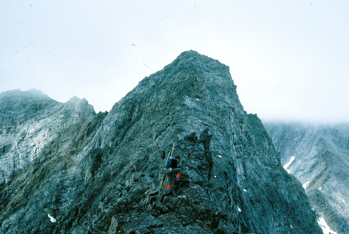 Climbing the final pitch of the Minaret Ridge to the Caubvick/d'Iberville peak Photo: Hazen Russell, Iapetus Ocean Expeditions (1982) |
Quoting Ray Chipeniuk: "A glorious panorama spread out on every side. Eastward were sharp coastal peaks and icebergs on the blue Labrador Current ... Southward the vast trench of Koroc River ... Westward the Tallek Arm and rivers beyond ... Northward the dark blue of Nachvak Fiord on the other side of which marched one tangle of mountains after another ...
"There was something else ... The (summit) was the intersection of three ridges. Along two of those ridges, the Minaret and the Koroc, ran the Quebec-Newfoundland border. Some ten meters out along the third or "North" ridge, and by just so much in Newfoundland-Labrador territory, was the summit of the mountain, the highest point in Canada east of the Rockies and south of Baffin Island. ... someone proposed that, until such time the province of Newfoundland confers an official name, it should be called "L1" -- "L" for Labrador, "1" for highest." (This was peak was subsequently named "Mount Caubvick" in 1981)
(1978 Torngat Mountain Expedition, A Report to the Newfoundland Dept. of Tourism, Ray Chipeniuk, 1979.)
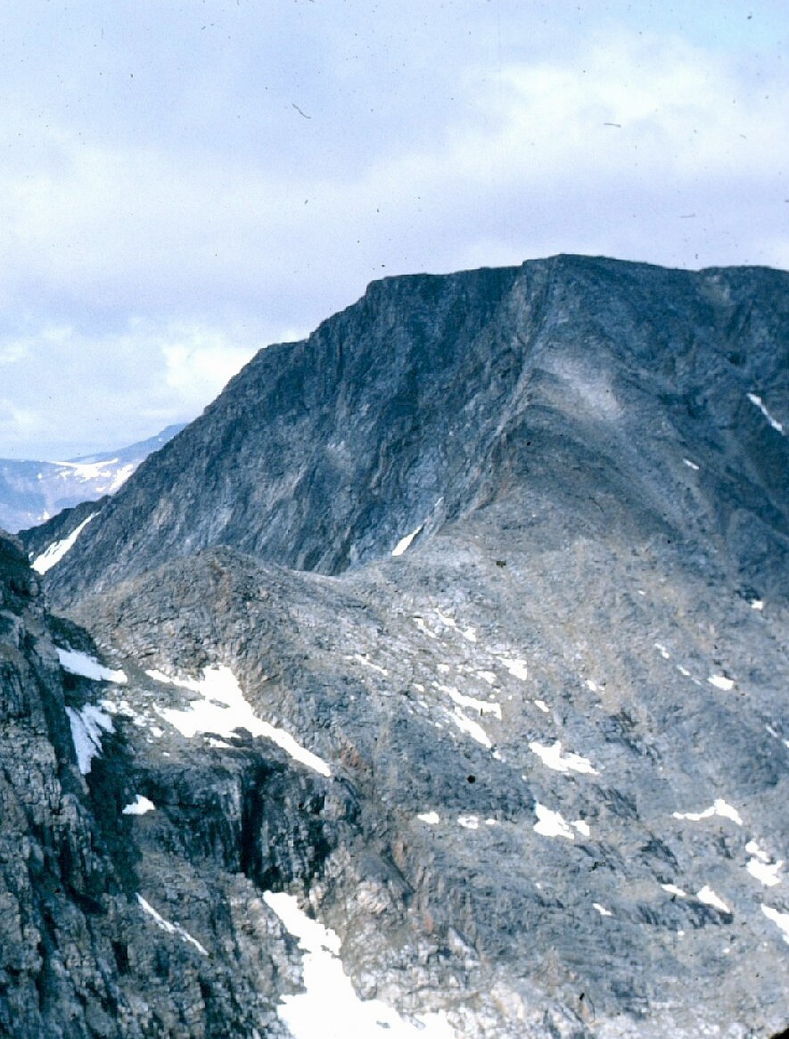
 The West Face (right) and North Ridge of Caubvick/d'Iberville Photo: Geological Survey of Canada (1982) |
(Baxter, Brian, "Torngat Mountain Expedition 1979", CAJ, Vol. 63, 1980)
Hazen Russell and Tim Kelliher, 7/29/1982: a first ascent via this route.
 Climbing onto the North Ridge at the col from the L1 Glacier Photo: Hazen Russell, Iapetus Ocean Expeditions (1982) |
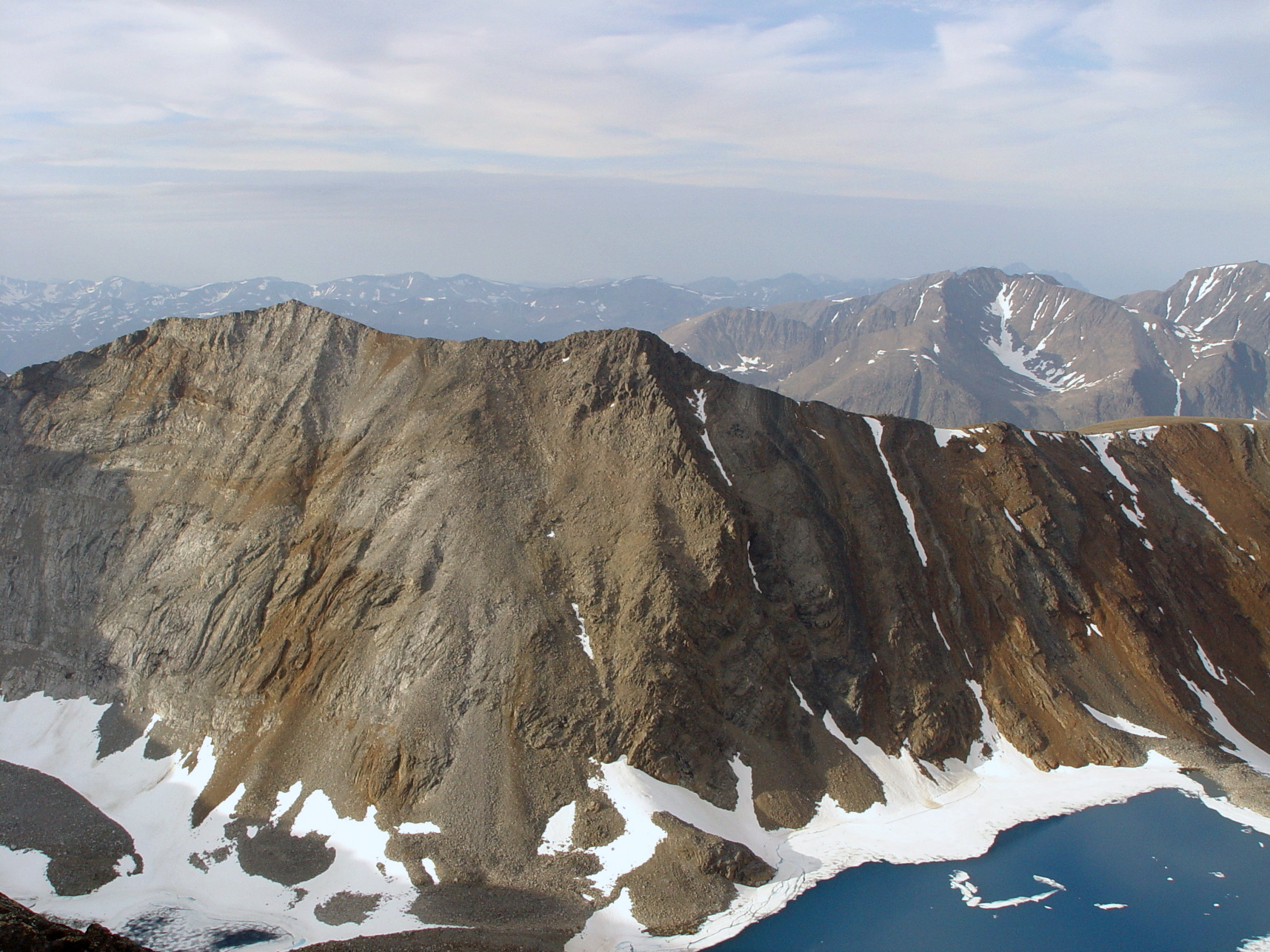
 The Koroc Ridge from the south showing Caubvick/d'Iberville Photo: Chris Rush (2004) |
Past the cairns the ridge became narrow and exposed. Jack Bennett has said this portion of the ridge is "MUCH more exposed than the (knife edge on Borah or Katahdin) ... the Koroc Ridge is only inches wide and terrifically exposed. It takes a lot of macho to walk upright on that edge
 The Koroc Step Photo: Andrew Lavigne (2004) |
Finally the party came to a notch of softer orange-red rock (the so-called "Koroc Step") with a drop of about 30', requiring an anchor and a rappel down into the notch (YDS 5.6). Past the notch were two pinnacles which were passed on the right and left and then the final steep pitch to the summit. The rope was left in place at the notch for a top belay on the return. The time from leaving base camp to the summit was just over 5 hours.
"Clouds were blowing on and off the summit at times revealing spectacular scenery ... A breathtaking drop on the north side fell away to Ice-Blue Tarn, still frozen in mid-August."
(Not Won in a Day, Jack Bennett, 1999.)
Topographic Map of Torngasoak: Click for map.
Michael Adler, Virginia Adler, Steve Loutrel, Elizabeth Loutrel, Warren Hofstra, 1975 (first ascent): From a base camp at the end of the Tallek Arm the team proceded up a ravine towards the south-east, initially over rock and then over snow, reaching a pond at around 2000'. Continuing south-east they climbed up another rocky ravine to a broad ridge. The route then proceeds north-east along the broad ridge to the summit. Although steep at times, the route was non-technical the entire way.
The party noted a variety of extremely technical routes up virtually every other ascent route. To quote Michael Adler: "The view from the summit is exceptional offering impressive views of the Nachvak Fiord and the other 5000 foot mountains of the region including d'Iberville to the east. The sheer 3000 foot drop off the north side of the mountain is quite extrordinary. Several impressive knife edges with large chunks missing and a large glacier complete the view."
(Adler, Michael, "Mt. Goetze", CAJ, Vol. 63, 1980)
Topographic Map of Cirque: Click for map.
 Cirque Mountain in the late afternoon sun View from the Minaret Ridge Photo: Andrew Lavigne (2004) |
Topographic Map of Erhart: Click for map.
 Mount Erhart (Margaret Toth) with Ice Blue Tarn below Photo: Andrew Lavigne (2004) |
Ray Chipeniuk, Ron Parker and Erik Sheer, 1978 (first ascent): from the base camp on the McCormick River the team ascended via Gneiss Brook, using ledges high above the right (north) bank to bypass Snowbridge Canyon. They ascended the north-east ridge over gently stepped bedrock and consolidated talus and reached the parymidal east peak in less than 5 hours. Ron parker built a cairn.
Since the west peak appeared to be the higher one, they scrambled and boulder hopped for about a half mile along the overhanging ar�te to the "mildly sensational" west peak. The west peak has a dramatic 1200' south-east face composed of hard grey gneiss. The team estimated that any person in resonably good condition could do the climb in about 5 hours with minimal exposure or danger from loose rock.
In the opinion of the first ascent team, Margaret Toth affords unparallelled views of Caubvick/d'Iberville, the L1 Glacier, Ice Blue Tarn, the "incredible" Grape Blue Tarn and all the farther scenery of this special area.
Decent was made via the talus slope on the north side of the connecting ar�te to Rockbowl Tarn and thence down Gneiss Brook.
(1978 Torngat Mountain Expedition, A Report to the Newfoundland Dept. of Tourism, Ray Chipeniuk, 1979.)
Topographic Map of Jens Haven: Click for map.
 Jens Haven (Gneissberg) with Erhart in front and Torngasoak behind Photo: Andrew Lavigne (2004) |
John Andrachuk and Erik Sheer, 1978 (first ascent): the climbers approached via the north-east ridge, on which John had put up a route the previous day via an ice couloir to about 3000'. They left base camp at 8:00 and reached the start of ice (about 1925') at 10:30. They cramponed up the couloir for 18 leads terminating around 3100'. Above that they climbed another five 150' pitches over class IV rock (Class IV =~ YDS 5.3 - 5.4), topping out on the ridge plateau at 3500'.
They travelled along the ridge about 2 miles to the great col which is the most distinguishing feature of this mountain. Rather than attempting the unsound red gneiss in the col, they traversed along the south-west face until they were opposite the high point of the summit plateau. They then climbed three rock pitches of difficulty YDS 5.1 - 5.4 straight up the face. Two big gendarmes provided the major obstacles on this route.
They reached the summit at 19:00, about 10:30 hours after setting out. They hurriedly built a cairn and took a few photos and as soon as possible started down.
They retraced their route down and over to the col. But hoping to save time, they contoured along the south-east flank of the mountain rather than climbing and following the ridge from the col. In doing this they were slowed by the need to detour around the heads of several steep gullies. After traversing this face for about a mile they realized that with darkness approaching, they might not find where they had left their ice gear, so they decided to remount the ridge and set about extablishing a crude stone shelter for a bivouac.
Sleeping intermittantly from about midnight till 6:00 the next morning, they started down the ridge, while a snow storm was gathering below them. They downclimbed many pitches in a violent windsquall, and finally staggered into camp at 14:00 as the storm was upon them.
(1978 Torngat Mountain Expedition, A Report to the Newfoundland Dept. of Tourism, Ray Chipeniuk, 1979.)
Topographic Map of Selamiut Tower: Click for map.
Ray Chipeniuk, Ron Parker and Erik Sheer, 1978 (first ascent): The summit team, together with Donna Hackett and Ron Wilson, made their way from the base camp on the McCormick River up Brook Four and Selamiut Brook, over loose angular fragments of rock through the stupendous chasm between Selamiut Tower and Gneissberg. They climbed over a box-canyon lip to Windgap Tarn and then over more talus and some loose snow to the col (about 3700') between the Tower and the ridge to the north leading to Torngasoak. This route essentially circled the Tower from the south and around the west side to the north side (see the map).
From the col they estimated that an alternate route up Tower Brook which drains Tower Tarn on the north side of the Tower would be difficult due to the amount of debris on the headwall above Tower Tarn.
They discovered the north-east face was not suited to climbing, being composed primarily of rotten red gneiss, and so they started up the north-west face. This involved about 300' of scrambling up steep scree and talus but they then faced a cliff band of 400' to 500' of elevation, which ran along the entire face and which could not be circumvented. All five in the party scrambled through the cliffs independently but they soon decided to split the group and Donna and Ron Wilson stayed behind at the cliffs while the other three went on ahead. Moves on this section were no harder then YDS 5.3 and furthermore they thought careful route selection might have reduced the climbing to a matter of scrambling up ledges and gullies.
After surmounting the cliffs, the summit party reached the plateau and arrived at the summit peak about 8 hours after leaving base camp. A cairn was built on the summit which was in a direct line-of-site to their base camp, 4300' below.
The party then descended and rejoined the other members and despite a forced march back to camp, a few members of the group did not return to camp till after 21:30, 14:30 hours after leaving.
(1978 Torngat Mountain Expedition, A Report to the Newfoundland Dept. of Tourism, Ray Chipeniuk, 1979.)
Topographic Map of North Caubvick: Click for map.
 Peak 5100 (North Caubvick) from the south-east Photo: Hazen Russell, Iapetus Ocean Expeditions (1982) |
From the summit plateau an ar�te stretches south and becomes the North Ridge of Caubvick/d'Iberville and another
ar�te heads north between two glaciers to Mount Erhart. This peak is in the very heart of the central Selamiuts.
Topographic Map of Starshape: Click for map.
 Starshape Mountain Photo: Geological Survey of Canada (1982) |
After about 30 rope lengths of climbing on excellent ice, starting from about 2700', he attained the fractured rock on the south-east ridge. He then scrambled up the few hundred feet remaining to the summit, moving first north-west and then due west. He raised a small cairn.
He returned to camp via the same route arriving at 21:00 after a 12 hour day.
(1978 Torngat Mountain Expedition, A Report to the Newfoundland Dept. of Tourism, Ray Chipeniuk, 1979.)
Topographic Map of 5074: Click for map.
Dartmouth College group (John Stix, Jill Fredston, Jim McIntyre and Steve Thompson), 1979 (first ascent): From the Palmer River the group scrambled up the steep western wall of the river valley up the stream gulley at 490303, about 3 miles upstream (south) of their base camp. After reaching the uplands at about 2500', they circled around several small ponds to the north and then approached the ridge leading to Peak 4900 by scrambling up a snow gulley and a talus slope. Heading due west along the broad ridge they encountered a huge ice field which they then crossed. Above the ice field they attained the broad summit of peak 4900 heading slightly south of west from the top of the ice field. A quick lunch was taken as the weather was thickening. Their altimeter read in excess of 5000'.
Peak 5074 was about a mile due south, separated from Preak 4900 by about a 400' drop to a col. They traversed this ridge in steadily worsening conditions of wet snow and near zero visibility and reached the summit of 5074 where they broke out the Dartmouth Outing Club Flag and took the obligatory summit shots.
They headed back across the col towards 4900 and, turning east, recrossed the icefield. Looking for a better route than the snow and talus gulley they had ascended, they found a long 1000' vertical drop snowfield which they glissaded down on their boots and rear ends. After a long day in miserable weather, they found their reward at the end.
(Stix, John, "Northern Labrador Expedition", Explorers Journal, December 1981)
Topographic Map of Razorback: Click for map.
Mount Razorback is an immense jagged crest that stands guard on the north at the entrance to Nachvak Fiord. Alexander Ford, whose seminal 1931 expedition mapped this area, said: "Nothing along the whole coast of Labrador is so spectacular". Noel Odell, the geologist and mountaineer on the expedition, upon summiting the west peak in 1931, said: "Without a parallel on all the American coast. ... the situations and scenery were in effect a blend of Norway, the Coolins and the Charmoz, though one hesitates to drive analogies, claimed in moments of exuberence, too far!"
Ray Chipeniuk, Ron Parker and Erik Sheer, 1978 (first ascent): The team was transported by boat to a landing they christened "Bivouac Cove" which was on the ocean side of the mountain about 2 miles north of the entrance to the fiord. The team hiked easily up along a brook to the west for about a mile and then turned north passing Razorback Tarn in about another mile and arrived at Razorback Glacier. Turf gave way to bedrock or stable talus which gave way to firm snow laying over the glacier which could be climbed without kicking steps. The team steered to the east side of the glacier, avoiding the bergschrund, and entered a gully which after about 600'of scrambling led to the east ridge.
They topped out on the ridge and ascended on excellent granite. (A rare species knowm as "charnockite".) The climbing was continuously exposed and demanding. If not for the limited time available every pitch would have been roped, but in the situation only one pitch was roped and another belayed. Otherwise the team soloed "carefully but quickly and masterfully".
The ridge rose in succesive steps, each harder than the last until near the top they reached the crux which offered a choice of a chimney topped by a roof with a window, which would not have permitted a retreat once commited, or a series of very narrow ledges with lie-back corners with no horizontal holds. The latter was chosen and Ray and Erik soloed up past this area to the ridge top from which they belayed Ron up. This 50' pitch was estimated to be YDS 5.4 to 5.6. From there to the summit it was but a pleasnt walk over the rather flat crest.
They arrived at the summit at 5:00 PM with late afternoon sun slanting through snow. Upon observing the narrow ridge which connected the summit to the west peak, Chipeniuk wrote: "Nobody wondered any longer why Odell had chosen not to cross the "Aiguilles Ridge" to Razorback's true summit: it was just one needle-sharp gendarme after another, many of them leaning into space like spectators straining not to miss the climax of an exciting event in a sports arena".
Descent was accomplished by several rappels and some "dicey" downclimbing. They arrived back at the cove at 10 PM but as agreed, their boat had already left with two other climbers and so they established a not-unpleasant bivouac.
(1978 Torngat Mountain Expedition, A Report to the Newfoundland Dept. of Tourism, Ray Chipeniuk, 1979.)
| I |
Torngat Private Search Expedition: Andrew Lavigne's excellent,
if sobering, account of the August 2004 search expedition to Mount Caubvick, organized by Roland Hanel and Jack Bennett,
the purpose of which was to locate the remains of Susan Barnes and Daniel Pauze, who were lost on Mount Caubvick
in August of 2003.
 Mount Caubvick/Mont d'Iberville from the east, the Minaret Glacier in the foreground Photo: Geological Survey of Canada (1982) |
| M |
Peak names: All names listed are names officially recognized by the Canadian government except names listed in quotations e.g. "North Caubvick", which are not officially recognized but are in general use. When there is an unofficial name in use as well as an official name, the unofficial name is included in parentheses after the official name e.g. Mount Erhart ("Margaret Toth").
Unnamed peaks are designated by their elevation, e.g. Peak 5000. Since the table includes both the NTS Map number and the abbreviated UTM coordinates for each peak, it easy to find unnamed peaks (or any peak) on the appropriate maps and when thus qualified, e.g. "Peak 5000, Map 24P01, UTM 328519", gives a unique designation (since there may be several unnamed peaks with the same elevation).
Since many of the peak names are not standardized in the available literature (gazatteers, climbing reports, etc.), and the notation for unnamed peaks varies, it is always best to identify a peak by its elevation and location (UTM or latitude/longitude) in addition to its name.
Elevation and prominence units: All elevations and prominence values are given in feet since the original sources (the NTS maps) for this region use this unit exclusively. Although many atlases and other sources now use meters, we have not converted these data to that unit since the hiker and climber will likely be using the available maps.
Elevations: For peaks with no spot elevation available (and most peaks fall into this category), the elevation of the highest contour surrounding the peak is used. Given that the contour intervals on the maps is in all cases 100', these elevation values will be multiples of 100' and the actual elevation may be up to 100' higher. A plus sign ("+") is added to the elevation value in the list to indicate this uncertainty.
Prominence: For a discussion of prominence, check Aaron Maizlish's excellent site: Peaklist.org. In a nut shell, prominence measures how high a peak stands above its col or saddle to the next higher peak. Many enthusiasts favor prominence as a measure of the "quality" of a peak, and often they use the nick name "Finest" to categorize the most prominent peaks in a particular area. Eliminating low prominence peaks from a list, serves to "weed out" inconsequential bumps that surround prominent peaks. For a prominence map of the Torngats (created by Greg Slayden) showing the 2000+' prominent peaks and the divides (ridge lines) and saddles connecting them, click here: Torngats Prominence Map.
Since prominence values depend on the height of the col to the next higher peak, and since these are known only from the next higher countour shown on the maps, the actual prominence may be up to 100' higher than listed (or up to 200' higher if the peak elevation is not a spot elevation). Prominence values calulated this way are called "clean prominence", and because of this uncertainty, they should be considered lower bounds for the actual prominence.
UTM notation: see above, in the map section for an explanation of UTM and the abbreviated UTM notation used on this page to give locations.
Datum used for locations: All location information (both UTM and latitude/longitude) use the NAD27 Canada datum, since this is used on all the maps. In point of fact, the difference bewtween these values and those given using WGS84 would not be significant given the accuracy of the maps: about 60m east/west and about 220m north/south. Obviously, hikers should not depend on the values given (or any value that can be read from the available maps) to find the exact location of any feature.
First ascent: Where the first ascent of a peak is known, the year of the ascent is listed in the "Ascent" column and a description of the ascent is linked, giving the members of the party, the date and any details of the ascent which are known, such as route and conditions.
Listing criteria: My ultimate goal is to identify all peaks with a prominence of 500' or more (plus any named peaks with lower prominence). However, since the actual prominence of most peaks in this region is uncertain and may be up to 200' greater (see above), I would also hope to identify all peaks with between 300' and 500' of prominence. Given the high relief of the terrain in this area, this would be well nigh impossible. So I have applied some secondary criteria: start with peaks above 4000' and list all of those with 300' or greater prominence (and rank those with 500' or more of prominence). Next, for lower peaks, list those with 500' or more of prominence and work down. As a work in progress, I believe we are very close to the first group (the 4000s) and I am slowly working my way down through the 3000s. For lower peaks I have initially tried to find peaks with 1000'or more of prominence and have listed them.
The List: The following list is built from the same data as the lists on Greg Slayden's site: Peakbagger.com (based on work by Greg and myself) and aside from minor formatting differences, should be identical to Greg's lists. By clicking on a peak name, a page of details from Greg's site is presented in a separate window.
| List of Torngat Peaks by Elevation | |||||||
| Peaks List copyright 2004 Greg Slayden based on work by Greg Slayden and Papa Bear | |||||||
| Rank | Elev. | Prom. | Name | NTS Map | UTM1 | Location | Ascent |
| 1 | 5420 | 4485 | Mount Caubvick ("L1") | 14L13 | 591275 | 58.8874 -63.7104 | 1973 |
| - | 5419 | 0 | Mont D'Iberville | 14L13 | 591275 | 58.8873 -63.7104 | 1973 |
| 2 | 5232 | 2332 | Torngarsoak Mountain | 14L13 | 545340 | 58.9451 -63.7907 | |
| 3 | 5144 | 2644 | Cirque Mountain | 14L13 | 676312 | 58.9211 -63.5620 | |
| 4 | 5100+ | 4200 | Peak 5100 | 24I16 | 399324 | 58.9293 -64.0436 | |
| 4 | 5100+ | 6002 | "North Caubvick" | 14L13 | 584282 | 58.8934 -63.7213 | |
| 6 | 5074 | 1674 | Peak 5074 | 14L13 | 443295 | 58.9038 -63.9662 | |
| 7 | 5049 | 549 | Mount Erhart (Margaret Toth) | 14L13 | 585293 | 58.9033 -63.7203 | |
| 8 | 5023 | 923 | Jens Haven (Gneissberg) | 14L13 | 576303 | 58.9118 -63.7366 | |
| 9 | 5000+ | 3600 | Peak 5000 | 24P01 | 328519 | 59.1027 -64.1732 | |
| 9 | 5000+ | 2500 | Peak 5000 | 24I16 | 370357 | 58.9581 -64.0946 | |
| - | 5000+ | 300 | "Mount Erhart - East Peak" | 14L13 | 593294 | 58.9043 -63.7061 | |
| 11 | 4951 | 2951 | Innuit Mountain | 24P01 | 361469 | 59.0582 -64.1143 | |
| 12 | 4900+ | 900 | Peak 4900 | 24P01 | 335497 | 59.0835 -64.1603 | |
| - | 4900+ | 400 | Peak 4900 | 14L13 | 438315 | 58.9215 -63.9760 | |
| - | 4900+ | 300 | "South Innuit Mountain" | 24P01 | 358455 | 59.0462 -64.1191 | |
| - | 4849 | 149 | Packard Mountain | 24P01 | 355443 | 59.0354 -64.1242 | |
| 13 | 4824 | 2424 | "Mount Barnes-Pauze" | 14L13 | 482222 | 58.8386 -63.8966 | |
| 14 | 4800+ | 1200 | Peak 4800 | 14L13 | 621243 | 58.8587 -63.6573 | |
| 15 | 4800+ | 500 | Peak 4800 | 24I16 | 350332 | 58.9357 -64.1286 | |
| 16 | 4786 | 3786 | Peak 4786 | 14L12 | 450410 | 58.6754 -63.9487 | |
| 17 | 4766 | 1666 | Mount Cladonia | 14L13 | 665369 | 58.9724 -63.5835 | |
| 18 | 4751 | 951 | Mount Silene | 24I16 | 417382 | 58.9811 -64.0150 | |
| 19 | 4750 | 950 | Selamiut Tower | 14L13 | 570319 | 58.9266 -63.7463 | |
| 20 | 4700+ | 1900 | Peak 4700 | 24I16 | 400194 | 58.8118 -64.0394 | |
| 20 | 4700+ | 700 | Peak 4700 | 24P01 | 322543 | 59.1248 -64.1847 | |
| 20 | 4700+ | 600 | Peak 4700 | 24I16 | 418277 | 58.8874 -64.0102 | |
| 20 | 4700+ | 500 | Peak 4700 | 24P01 | 330534 | 59.1167 -64.1702 | |
| - | 4700+ | 400 | Peak 4700 | 14L13 | 427357 | 58.9586 -63.9966 | |
| 24 | 4686 | 3586 | Peak 4686 | 14L12 | 606913 | 58.5621 -63.6767 | |
| 25 | 4650 | 1850 | Starshape Mountain | 14L13 | 640365 | 58.9682 -63.6266 | |
| - | 4632 | 332 | Peak 4632 | 14L13 | 687346 | 58.9518 -63.5440 | |
| 26 | 4556 | 656 | Peak 4556 | 14L13 | 650313 | 58.9220 -63.6087 | |
| 27 | 4553 | 3253 | Mount Eliot | 14M04 | 531604 | 59.1816 -63.8201 | |
| 28 | 4534 | 1334 | Peak 4534 | 14L13 | 439215 | 58.8314 -63.9713 | |
| 29 | 4500+ | 1800 | Peak 4500 | 14L12 | 548947 | 58.5926 -63.7782 | |
| 30 | 4500+ | 1200 | Peak 4500 | 24P01 | 293504 | 59.0891 -64.2340 | |
| - | 4500+ | 400 | Peak 4500 | 24I16 | 384394 | 58.9912 -64.0718 | |
| 31 | 4449 | 3349 | Mount Tetragona | 14M05 | 476745 | 59.3076 -63.9203 | |
| 32 | 4400+ | 4200 | "Four Peaks High Point" | 14M12 | 436983 | 59.5209 -63.9963 | |
| - | 4400+ | 300 | Peak 4400 | 24I16 | 329328 | 58.9311 -64.1648 | |
| 33 | 4300+ | 3000 | Peak 4300 | 14L11 | 920945 | 58.5929 -63.1370 | |
| 33 | 4300+ | 2700 | Peak 4300 | 24P01 | 280599 | 59.1737 -64.2602 | |
| 33 | 4300+ | 1600 | "West Koroc Mountain" | 14L12 | 499710 | 58.7034 -63.8641 | |
| 33 | 4300+ | 500 | Peak 4300 | 14M04 | 555604 | 59.1827 -63.7782 | |
| 37 | 4249 | 1049 | Mount Faunce | 14M04 | 513599 | 59.1774 -63.8519 | |
| 38 | 4200+ | 2300 | Peak 4200 | 24P01 | 244635 | 59.2053 -64.3236 | |
| 38 | 4200+ | 900 | Peak 4200 | 14L13 | 700270 | 58.8840 -63.5198 | |
| 38 | 4200+ | 600 | Peak 4200 | 24P01 | 310547 | 59.1278 -64.2055 | |
| - | 4200+ | 300 | Peak 4200 | 14L13 | 703290 | 58.9016 -63.5151 | |
| 41 | 4137 | 2337 | Mont Jacques-Rousseau | 24P07 | 116726 | 59.2851 -64.5509 | |
| 42 | 4100+ | 3200 | "Four Peaks - South Peak" | 14M05 | 456922 | 59.4668 -63.9605 | |
| 42 | 4100+ | 2000 | Peak 4100 | 24P01 | 298435 | 59.0272 -64.2231 | |
| 42 | 4100+ | 1700 | Peak 4100 | 14L12 | 482926 | 58.5729 -63.8899 | |
| 42 | 4100+ | 900 | Peak 4100 | 24P01 | 307602 | 59.1773 -64.2128 | |
| 42 | 4100+ | 600 | Peak 4100 | 24P01 | 232656 | 59.2241 -64.3461 | |
| - | 4100+ | 400 | Peak 4100 | 24P01 | 308623 | 59.1957 -64.2113 | |
| - | 4100+ | 300 | Peak 4100 | 24P01 | 300610 | 59.1840 -64.2252 | |
| 47 | 4077 | 2577 | Mount Pinguksoak | 14L06 | 891744 | 58.4121 -63.1867 | |
| 48 | 4000+ | 2200 | "Four Peaks - East Peak" | 14M12 | 470972 | 59.5119 -63.9369 | |
| 48 | 4000+ | 1200 | Peak 4000 | 24I16 | 354244 | 58.8562 -64.1190 | |
| 50 | 3950 | 950 | Koroc Mountain | 14L12 | 544720 | 58.7045 -63.7863 | |
| 51 | 3945 | 2445 | Peak 3945 | 14M04 | 617548 | 59.1322 -63.6691 | |
| 52 | 3900+ | 2100 | Peak 3900 | 14L05 | 594714 | 58.3836 -63.6948 | |
| 52 | 3900+ | 1300 | Peak 3900 | 14L12 | 662854 | 58.5100 -63.5805 | |
| 52 | 3900+ | 800 | Adler Lookout | 14L13 | 624295 | 58.9054 -63.6518 | |
| 55 | 3891 | 2191 | Quartzite Mountain | 14L14 | 763349 | 58.9553 -63.4121 | |
| 56 | 3881 | 2581 | Blow Me Down Mountain | 14L14 | 945142 | 58.7697 -63.0943 | |
| 57 | 3800+ | 2200 | Mount Goetze | 14L11 | 941860 | 58.7198 -63.1017 | |
| 57 | 3800+ | 1800 | Peak 3800 | 14M04 | 590582 | 59.1625 -63.7169 | |
| 57 | 3800+ | 1400 | Precipice Mountain | 24P01 | 325594 | 59.1699 -64.1807 | |
| 57 | 3800+ | 800 | East Qarqaaluk Mountain | 14L12 | 458902 | 58.5510 -63.9314 | |
| 61 | 3700+ | 1900 | Peak 3700 | 14L11 | 891864 | 58.5200 -63.1876 | |
| 61 | 3700+ | 900 | Mount Ford | 14M04 | 528518 | 59.1043 -63.8245 | |
| 63 | 3679 | 2179 | Mount Kaputyat | 14M04 | 437519 | 59.1047 -63.9833 | |
| 64 | 3600+ | 2100 | Peak 3600 | 14L11 | 763918 | 58.5678 -63.4081 | |
| 64 | 3600+ | 2100 | Peak 3600 | 14L10 | 300350 | 58.6735 -62.9483 | |
| 66 | 3510 | 2510 | Mount Razorback | 14M03 | 765591 | 59.1726 -63.4110 | |
| 67 | 3507 | 907 | Mont Qarqaaluk | 24I09 | 384890 | 58.5393 -64.0580 | |
| 68 | 3500+ | 2700 | Kutyaupak Mountain | 14M04 | 468458 | 59.0499 -63.9280 | |
| 68 | 3500+ | 2600 | "Four Peaks - North Peak" | 14M12 | 449200 | 59.5543 -63.9751 | |
| 70 | 3400+ | 2000 | Peak 3400 | 24P08 | 403762 | 59.3220 -64.0483 | |
| 70 | 3400+ | 1800 | Peak 3400 | 14L11 | 990112 | 58.7428 -63.0167 | |
| 70 | 3400+ | 1700 | Mount Gerfalcon | 14M04 | 656530 | 59.1166 -63.6006 | |
| 70 | 3400+ | 1200 | Peak 3400 | 14L06 | 714788 | 58.4509 -63.4899 | |
| 74 | 3300+ | 2100 | Peak 3300 | 14M05 | 551699 | 59.2676 -63.7879 | |
| 74 | 3300+ | 1000 | Peak 3300 | 14L05 | 630769 | 58.4334 -63.6335 | |
| 76 | 3100+ | 1300 | Peak 3100 | 14M04 | 704585 | 59.1666 -63.5175 | |
| 77 | 3009 | 2409 | Mount Cornelius | 14M05 | 456820 | 59.3746 -63.9570 | |
| 78 | 3000+ | 2900 | "North Aulatsivik Island High Point" | 24P16 | 393240 | 59.7513 -64.0797 | |
| 78 | 3000+ | 2000 | "Four Peaks - Southeast Peak" | 14M05 | 509903 | 59.4498 -63.8668 | |
| 80 | 2970 | 2770 | Kammarsuit Mountain | 14M03 | 793488 | 59.0800 -63.3610 | |
| 81 | 2800+ | 2400 | Peak 2800 | 24P16 | 172457 | 59.9426 -64.4823 | |
| 82 | 2700+ | 2500 | Ikordlearsuk Mountain | 25A01 | 187553 | 60.0285 -64.4580 | |
| 82 | 2700+ | 2400 | Peak 2700 | 14M03 | 727451 | 59.0460 -63.4750 | |
| 82 | 2700+ | 2000 | Peak 2700 | 14L07 | 168795 | 58.4574 -62.7114 | |
| 82 | 2700+ | 1700 | Peak 2700 | 14M05 | 487801 | 59.3581 -63.9027 | |
| 82 | 2700+ | 1400 | Peak 2700 | 14L07 | 177773 | 58.4376 -62.6964 | |
| 87 | 2600+ | 1900 | Peak 2600 | 14M03 | 774447 | 59.0403 -63.3930 | |
| 88 | 2500+ | 2000 | Peak 2500 | 24P09 | 436155 | 59.6757 -64.0022 | |
| 89 | 2363 | 2263 | Peak 2363 | 14M03 | 866441 | 59.0378 -63.2334 | |
| 90 | 2300+ | 2000 | Peak 2300 | 14L14 | 964261 | 58.8770 -63.0620 | |
| 90 | 2300+ | 1900 | Peak 2300 | 14M05 | 686697 | 59.2671 -63.5505 | |
| 92 | 2100+ | 2000 | Mount Bache | 24P16 | 400344 | 59.8448 -64.0714 | |
| 93 | 2000+ | 1900 | Peak 2000 | 25A01 | 175672 | 60.1353 -64.4849 | |
| List of Kaumajet Peaks by Elevation | |||||||
| Rank | Elev. | Prom. | Name | NTS Map | UTM1 | Location | Ascent |
| 1 | 4000+ | 3900 | Brave Mountain | 14E16 | 579157 | 57.8812 -62.0239 | |
| 2 | 3652 | 952 | Bishop's Mitre | 14F13 | 603173 | 57.8955 -61.9831 | |
| 3 | 3300+ | 2900 | The Finger | 14E16 | 524197 | 57.9182 -62.1154 | |
| 3 | 3300+ | 2400 | Peak 3300 | 14F13 | 621122 | 57.8496 -61.9538 | |
| 5 | 3000+ | 3000 | "Cod Island High Point" | 14F13 | 719105 | 57.8323 -61.7889 | |
| 6 | 2700+ | 2100 | Peak 2700 | 14F12 | 784973 | 57.7128 -61.6844 | |
| 7 | 2600+ | 1700 | Peak 2600 | 14F13 | 786470 | 57.7796 -61.6776 | |
| 8 | 2500+ | 2500 | "Drachart Island High Point" | 14E16 | 482275 | 57.9885 -62.1851 | |
| List of Kiglapait Peaks by Elevation | |||||||
| Rank | Elev. | Prom. | Name | NTS Map | UTM1 | Location | Ascent |
| 1 | 3445 | 3145 | Man O'War Peak | 14C13 | 809145 | 56.9686 -61.6692 | |
| 2 | 3400+ | 2200 | Peak 3400 | 14E02 | 254394 | 57.1991 -62.5789 | |
| 3 | 3300+ | 2000 | Peak 3300 | 14E01 | 354228 | 57.0493 -62.4164 | |
| 3 | 3300+ | 700 | Peak 3300 | 14E02 | 282412 | 57.2150 -62.5334 | |
| 5 | 3200+ | 2100 | Peak 3200 | 14E01 | 421250 | 57.0685 -62.3061 | |
| 6 | 3100+ | 1300 | Peak 3100 | 14E01 | 339396 | 57.2003 -62.4397 | |
| 7 | 3000+ | 3000 | Mount Thoresby | 14C14 | 940950 | 56.9211 -61.4566 | |
| 7 | 3000+ | 2100 | Aupalukitak Mountain | 14E01 | 437355 | 57.1629 -62.2782 | |
| 7 | 3000+ | 1200 | Peak 3000 | 14D16 | 320109 | 56.9424 -62.4735 | |
| 7 | 3000+ | 1100 | Peak 3000 | 14D16 | 357149 | 56.9784 -62.4119 | |
| 11 | 2900+ | 2400 | Peak 2900 | 14D16 | 433149 | 56.9774 -62.2882 | |
| 11 | 2900+ | 2000 | Peak 2900 | 14D16 | 418760 | 56.8904 -62.0983 | |
| 11 | 2900+ | 400 | Peak 2900 | 14E01 | 549530 | 57.0917 -62.3604 | |
| 14 | 2800+ | 2700 | Mount Lister | 14D09 | 613842 | 56.6994 -61.9987 | |
| 14 | 2800+ | 1900 | Peak 2800 | 14F04 | 869330 | 57.1341 -61.5643 | |
| 14 | 2800+ | 1900 | Peak 2800 | 14E08 | 365463 | 57.2600 -62.3950 | |
| 14 | 2800+ | 1400 | Peak 2800 | 14E08 | 324453 | 57.2518 -62.4629 | |
| 18 | 2700+ | 1500 | Peak 2700 | 14D15 | 243971 | 56.8194 -62.6021 | |
| 18 | 2700+ | 1200 | Peak 2700 | 14F03 | 924333 | 57.1357 -61.4737 | |
| 20 | 2600+ | 2400 | Peak 2600 | 14E01 | 516320 | 57.1300 -62.1478 | |
| 21 | 2600+ | 2000 | Peak 2600 | 14E07 | 284589 | 57.3742 -62.5272 | |
| 22 | 2500+ | 900 | Peak 2500 | 14D15 | 180830 | 56.9200 -62.7040 | |
| 23 | 2400+ | 1600 | Peak 2400 | 14D16 | 412450 | 56.8847 -62.3237 | |
| 23 | 2400+ | 1200 | Peak 2400 | 14C13 | 881370 | 56.8704 -61.5555 | |
| 23 | 2400+ | 300 | Peak 2400 | 14E01 | 378344 | 57.1530 -62.3760 | |
| 26 | 2300+ | 600 | Peak 2300 | 14E02 | 249430 | 57.2317 -62.5883 | |
| 27 | 2200+ | 800 | Peak 2200 | 14D10 | 261861 | 56.7200 -62.5730 | |
| 28 | 2000+ | 900 | Peak 2000 | 14D09 | 471300 | 56.8700 -62.2270 | |
| 29 | 1900+ | 900 | Peak 1900 | 14E07 | 208557 | 57.3455 -62.6551 | |
| 30 | 1900+ | 900 | Peak 1900 | 14E07 | 302516 | 57.3085 -62.4991 | |
| 31 | 1700+ | 1100 | Peak 1700 | 14D16 | 491400 | 56.8470 -62.1950 | |
| 31 | 1700+ | 1100 | Peak 1700 | 14D16 | 360915 | 56.7681 -62.4107 | |
| 33 | 1500+ | 1500 | Peak 1500 | 14C12 | 916662 | 56.5336 -61.5113 | |
| Notes: 1 The "UTM" column gives the 6 digit abbreviated UTM cordinates as explained in the map section. 2 The low point on the North Ridge is shown on map 14L13 as 4600-4700'. Photographs would indicate a value of 4500' is more probable, increasing the prominence of "North Caubvick" to about 600'. | |||||||
General:
Mountaineering Journal Articles:
Some Classics:
|
Click here for an album of photos of the Torngats |