
Snow Covered Mount Greylock in the Morning Sun
|
Snow Covered Mount Greylock in the Morning Sun |
|
Click here for a complete album of photos from this hike Click for Papa Bear's Home Page Click for the Backpacking Page |
his was the second of a series of section hikes that my partner and I have decided to undertake this summer. In April we did 171.8 miles from the Delaware Water Gap to Kent Connecticut. For an account of that section see Section 1 hike. We hoped to progress from section to section improving our fitness, our planning and tuning our selection of gear. We expect to get to Katahdin in 2 week segments by mid September. I expect we will start to see north bound thru-hikers by July (in the Whites), and by September it should be like Grand Central Station on the big K.
My primary characterization of this section was that the terrain, although higher in altitude (the highest point in our first section was Sunrise Mountain in NJ at 1653') was less rocky and steep. This, together with our better fitness made the ups and downs rather comparable even though the high point (Stratton Mountain 3941') was over twice that height. Our average daily mileage was almost identical to that in our first section (13.2 miles/day).
The most memorable feature of this hike was the weather. We had two systems of rough weather. Starting with our climb of Bear Mountain (the Connecticut Bear Mountain, not the New York Bear Mountain) we had showers that continued off an on for about 3 days. By day 4 when we sought shelter at the Egremont Inn (South Egremont, Massachusetts) we were walking literally in a downpour. This weather system slowly moved off and by the end of day 6 we saw blue sky and sun again. By day 8 it had become warm enough to be bothered by black flies while cooking dinner. We were in tents at the Crystal Mountain Camp Site that night and during the night we heard rain and by morning snow on the tent fly. We awoke to 2 inches of snow on the ground and temperatures in the low 30s. The next 5 days then became what I would call near winter camping conditions. We trekked Day 9 down to Cheshire Mass. (where it was raining) then up Mount Greylock where the snow was 8 inches deep when we got there in mid afternoon. The next morning broke with beautiful sun and blue sky and 30 degrees on the Greylock summit. This cold lasted all the way to Stratton in Vermont, with morning temperatures between 20 and 30 and daily highs seldom over 40. Finally on the last day the morning temperature was around 40 and by the time we got to Manchester, our finishing point, it was close to 70. From Summer to Winter and back in 2 weeks. Whatever happened to Spring? (It was just one evening: with my bug net on at Crystal Mountain)
The season was also a little unusual. In April when we hiked along the New Jersey and New York ridges, very few of the deciduous trees were in leaf. This time we expected Spring would be in full bloom. Well, below about 2000 feet it was. But above that altitude the Beech and Birch forests of Massachusetts and Vermont were still quite bare. Spring had not yet fully arrived in the high country of New England. In addition, we were delighted to see the Red Spruce and Balsam Fir groves at higher altitudes.
We also surmounted a series of increasingly higher peaks. Our first 2000+ was Bear Mt. at 2316' (the first 2000+ on the AT north of Virginia, no?) followed by Everett (2602') the first 2500+. Then Greylock (3491'), the first 3000+, really what I would call a near 3500+ (the monument goes well over 3500'). Then in Vermont we hit Little Pond Lookout (3060'), Glastonbury (3748') and finally Stratton (3941') a "near" 4000+ (the fire tower will put you over that mark). It was almost as if all the tallest peaks were lined up in size order from Bear Mt. in Connecticut on up through Massachusetts, Vermont and later into New Hampshire to Mt. Washington. Almost
The other interesting and unexpected happening was that the weekend we entered Vermont seemed to be the start of prime thru-hiking season on the Long Trail. The first 2 days in Vermont we saw at least 13 LT thru-hikers of various speeds and capabilities passing along. What had been primarily an empty Appalachian Trail became a very busy Long Trail. We even had an older gent ask us as we crossed Route 2 in North Adams Mass, heading towards Vermont: "Are you guys hiking the Long Trail?". Of course we said yes. In Vermont it seems to be "You say you're hiking the Appala-what Trail?".
in skivvies: 163 lb.
add boots and clothes: 170 lb.
add tummy pack: 173 lb (includes Gatorade for day 1)
add back pack and Lekis: 210 lb (includes 2 liter water)
The backpack was 37 lb, down from 41 lb last section. That's some
improvement.
 The Housatonic River near Falls River |
The feature we kept coming back to was the Housatonic River. Time after time for almost 50 miles we would come back to this river, sometimes wild, some times tranquil, but always beautiful. A major thoroughfare in the 19th century, this river has reverted to it's pristine state as farms and factories have slowly disappeared from the region. The northern section of the state, over Bear Mountain to Sages Ravine (which actually overlaps the Massachusetts line) was Southern New England at it's best. A hidden, beautiful place. Go there, you'll see.
Connecticut is also rather strict in that camping is allowed only at designated campsites and open fires are prohibited. A little planning is needed to assure you get to a proper site for each day's trek. Camp Sites and Shelters do occur at fairly close intervals however so this should not be a problem. We stayed in one Lean-to and two campsites (the second over the Massachusetts line) while in Connecticut. On the last night of our previous section hike we also stayed in a Connecticut Lean-to, at the beautiful ten Mile River Camping area.
A word of Shelters: Connecticut seems to have a common design for Shelters (called Lean-tos). There is a front beam or log which is separated from the main floor by a gap which is at ground level. I'm not sure the origin of this. It's sometimes a pain, especially if you get up in the middle of the night and forget the gap is there.
resh Air and I met at Grand Central Terminal and took the 7:48 to Harlem Valley - Wingdale. Charlie would be waiting there to pick us up and drive us to the trail head. With one quick stop at the Outdoor Outfitters in Kent to pick up some maps, we arrived at the trailhead shortly after 10:15 AM. It was a warm sunny day.
 Papa Bear and Fresh Air at the Trailhead in Kent Connecticut |
The open meadow at the trail head was a bit too warm so we were glad to soon get under cover of the woods. Unlike the day over 3 weeks ago when we left this spot, the trees were mostly in full leaf.
 Looking down the St. John's Ledges |
Next came nearly 5 miles of level walking along the Housatonic. This is the longest river walk of the entire AT. Seeing how beautiful it was, I wonder that there isn't more of the trail in the river valleys, instead of always being on the ridges.
 Along the Housatonic |
I was running out of energy (and water). I found the steep ascents were tiring after the long layoff since our last hike. Fresh Air said there were 3 more "bumps" coming. The first was steep, bad. I snuck a drink of untreated water from a stream (it looked good) and felt better. Here it is the first day, hardly getting started and I'm running out of water too soon. The second bump was not so bad. We rested at Hatch Brook before the last bump. This was also not so bad (my illicit water helped a lot). We finally arrived at Caesar Brook Camp Site.
 At the Caesar Brook Campsite |
We saw an unusual mouse scampering around the campsite. It was not the usual mouse gray color. It was chestnut brown and light underneath. It hopped rather than scampered. Fresh Air christened it a "Kangaroo Mouse". We had bear bagged our food so we were not too worried about this mouse. I got to sleep and slept well. I had upgraded my 1 inch Thermarest pad to the next model (1.5 inch - only 3 oz. heavier) and this seemed to help. So the first day had beautiful weather, beautiful scenery, relatively easy hiking, and one tired hiker.
t was beautiful morning and a beautiful trail. We got off at 7:35 AM. The ups and downs were not too bad (or I was just in a better frame than yesterday). I had taped my left heel with duck tape and that was feeling good.
We stopped at Pine Swamp Lean-to for a break. This was notorious for it's voracious mosquitoes. The were 3 guys there, just getting their breakfast cleaned up. They said they had a few bugs last night but it was not too bad.
 The Guys at Pine Swamp Brook |
On the way down off the ridge I suddenly heard a noise right in front of me that I had never heard before but instantly knew what it was. I stepped back and we observed a fairly large Eastern Diamondback Rattlesnake right on the trail It was about 4 ft long and very fat in the middle. Fresh Air said if we moved back a ways he would probably cross the trail, so we did and he did. This was my first ever encounter with a rattler.
 Look closely: It's a Rattler on the Trail |
We crossed the bridge over the Housatonic and after passing a high school, the trail entered the woods between the road and the train tracks. This narrow corridor soon got wider and we recrossed the road so that the trail followed the river, now on the east side.
 Tall White Pines along the Housatonic |
We came out of the woods and went around an old power generating plant. It used hydro power and drew it's water from a dam a half mile or so up on the river. This was the famous Falls River Dam. The dam had been build just up stream from Great Falls, which at the moment were dry. The seemed to rise some 20 or 30 feet. It would have been marvelous to see the river crashing down these falls with a heavy spring flow but alas that was not to be. The trail crossed back to the west side of the Housatonic just below the dam and entered the woods. The ascent was not too steep, and we had some really nice hiking.
At the top of the ridge, a side trail led down a very steep cliff face to the Limestone Spring Lean-to. When we first looked down the slope, we said "Where is the trail". It was dirt and roots but was as steep as some of the rock ledges we had traversed. We got to the lean-to in a sheltered glen on the west side of the ridge and found the spring had a pipe coming straight out of the side of the ridge so I decided not to filter this one. I washed out my socks and shirt.
 The steep trail down to the lean-to |
While fresh Air and I were cooking and puttering around in the lean-to, we noticed a Phoebe flying back and forth and perching on a nearby tree. We looked carefully and found that her nest was right on top of the main roof beam in the center of the Lean-to. Fresh Air said he remembered similar nests in several of the shelters on our last section hike in April. Finally when we were sitting still at the back of the lean-to reading, she flew in and perched on the nest. I wondered why she would build a nest in such a busy place. But then again since the lean-to would be empty most of every day, and quiet at night, maybe it wasn't such a bad spot after all. Hopefully her brood would be out before the height of the thru-hiker season in this area.
 Limestone Spring Lean-to |
When it was practically dark, we saw a couple and a dog coming up the glen. I was worried we would have company, but they hiked on by, up the steep climb to the AT. They had a heavy rope and jugs of water. Maybe they were out for night climbing? A bit weird. Turns on they camped out on the ridge above and the knew this area. I never knew what the rope was for. When I went out in the night to pee, the stars would out very bright.
oday I taped up both heels with duck tape. As we were getting started around 7:35 AM, we heard a train whistle back from the direction of Falls River. When we reached the top of the ridge, we found the couple with the dog who had gone by last night camped on a nice spot overlooking a view at the top of a mountain meadow. One wonders who mows the grass up here. this was obviously old farm land as we traversed some rock walls along the ridge. The trail was steep but quite well built. We came down off the ridge to the outskirts of Salisbury Connecticut. We crossed the road and started up the next ridge which was the start of the climb up Bear mountain. This is the highest peak in Connecticut, but not the highest point. (That point is on the side of mountain whose peak is in Massachusetts.) Today my heels were OK with the tape in place, but the front of my right foot was hurting. It's taking some days for my feet and boots to adapt to each other. The sprinkles continued intermittently.
We first ascended the Lions Head, a steep narrow ridge with cow pastures in the lower reaches. The top of this climb is a rock ridge with a dramatic view back down to Salisbury.
 The View from Lion's Head |
We continued on and had our lunch break at the Riga Lean-to. This has a spectacular view to the East. The book said it was the only lean-to in Connecticut with a view. It was a beautiful setting. We passed an older dayhiker and a 30ish weekender going SOBO. He suggested we stay the night at Bear Rock, a mile or so past Sages Ravine since it was a beautiful, more open spot. By the time we got to Riga the sprinkles were coming more frequently.
 Bear Mountain in the Fog and Rain |
Sages Ravine is truly awesome. On the Connecticut/Massachusetts border, this is a deep gorge between Bear Mountain in Connecticut, and Race Mountain in Massachusetts. The book said some of the area has never been logged, ever. The river runs wildly down through hemlocks over rocks and rills. The rain and fog made it more forbidding. We passed down through the ravine for about a half mile, and then we had to cross the river by hopping over several large boulders just above a swirling falls. I didn't have the courage to try this in the rain, so I trudged across the ankle deep water above this point. Unfortunately my boots are not waterproof when water comes in over the top, so things were a bit wet. I only regret that the rain prevented me from getting any pictures of this awesome place.
We climbed the easy slope on the north side and in a little over a mile reached Bear Rock Camp Site. All the hikers and the maps show this name, but the name has suddenly disappeared from the Trail Guide and Databook. In it's place they mention a new area on the other side of the AT called Laurel Ridge Camp Site. This is new and didn't look too good, whereas Bear Rock stood on a nice area just by the cliff side. The stream which was the water source actually cascades right off the sheer face of the cliff (which we couldn't see due to the rain and fog). We later learned from a ridgerunner, that someone had recently fallen off the cliff face here (he actually said "someone took a dive off the cliff") and they are closing Bear Rock Campsite, reforesting it and opening Laurel Ridge Campsite. Too bad. This is such a dramatic place. I'd love to come back when it's not raining before they close it off.
The rain was steady now, so we set up our tents, cooked, and got inside for an early night. It was only 5:00 PM , but there was no where else to be but inside. My log book says "Rain, rain go away ..."
Day 3 Trail Miles 12.9; Other Miles .5
Total Trail Miles 42.1; Total Miles 43.1
am a native son of Massachusetts. I was born and raised in Quincy, birthplace of the 2 Adams presidents, and grew up steeped in the history and traditions of the state. I went to Williams College (in the Northwest corner of the state) which is practically on the AT. We went to Tanglewood in the summers, camped out near Mount Greylock and I still have a very good friend from College who lives in Pittsfield, also very close to the trail. And even though I long ago moved to New York City, both my children took up residence in Massachusetts after college.
 Upper Goose Pond |
Due to scheduling and weather we spent only one night in a Massachusetts Lean-to (Wilcox Mountain South). We spent one scheduled night in Pittsfield at my friend's house, one unscheduled night at the Egremont Inn in South Egremont, and we were lucky to stay at Bascom Lodge which had opened the night before we got there (and which was snow bound when we arrived). The other two nights we used our tents at campsites (Upper Goose Pond and Crystal Mountain).
Most of the lean-tos we saw were built in the late 80s and were spacious with a loft over the entrance which could sleep several extra hikers. Unfortunately the one lean-to we did use was built in the 30s by the CCC and had many gaps between the logs in the walls. Luckily it was not a windy night.
We came into Massachusetts in the rain, and we went out with 4 to 8 inches of snow cover from
a freak storm. But we still loved it all.
y first log entry is "tough wet morning". That just about says it all. We seem to always find ourselves tenting, rather than in a shelter on rainy nights. As a result, packing up seems to get everything wet, even stuff that was safely dry in the tent. Not really - all my sleeping stuff stayed dry plus my clothes, but all the food bags (which wrere hanging from a nearby tree), and of course the tent was wet. Rainy day campers know this of course. You get up, cook and eat in the rain, pack up and you have a pack full of wet stuff.
We climbed up Race Mountain (which we were already on the side of) and as we went by the dramatic views to the east, we saw fog and rain. It was actually quite eerie - almost as if a few feet off to the right side was an abyss, secret and forbidding. The ascent had steps built but was not too tough. As we noticed yesterday the rain seemed to abate at the top. The temperature was also rather cold, probably low 40s. The dampness of my clothes, plus the sweat from exertion gave me a chill when we stopped even briefly for a rest. Rain gear is great when it starts out dry (on the inside) and you have very light dry clothes underneath, but today was not that ideal situation.
 A Stormy Day on Race Mountain |
We stopped for a break in the Glen Brook Lean-to. I had hoped we could dry out and relax a bit there, but it was cold and damp like everything else so we quickly got moving again. We crossed the summit of Bushnell (don't they make binoculars?) We were going to try for the Tom Leonard Lean-to today, but we came to the conclusion that the 14 plus miles to get there, plus the fact that we couldn't really dry out properly when we did get there, that we would look for shelter off the trail. We found on our (very wet) Xerox pages from the Companion, that South Egremont Mass. and the Egremont Inn was 1.2 miles off the trail when we got to Route 41. The idea that we would go to a real New England Inn perked us up considerably. Bad stuff is endurable if you know it will eventually end.
We made it down the ridge to Jug End. Through a quirk of fate, the cloud cover briefly lifted and we had a brief but awesome view of the valley below and the mountains beyond. The descent to the valley was initially easy going, but I managed to lose my balance on a rock or a log and fell into the mud. Fresh Air said "Well at least you had a soft landing!". Yeah. After my fall, the descent got very steep and slippery and I managed to do one more "sit fall" as you might call it. Nothing broken.
We got to Jug End Road and crossed through a beautiful meadow filled with yellow flowers we couldn't identify. I counted 6 Black Angus cattle nearby. We got to Route 41 and started the road walk into town. The rain had now become a downpour. We got to the town and I stuck my head into an antique shop to find where the Inn was. He said the other end of town (naturally) so we trekked on in the rain, altogether about a mile and a half, and found the place. It was a beautiful white structure, built in 1780, with wide wood flooring and beautiful appointments. Carol, at the desk, was very nice and called to the young man helping her (Dennis): "There are two very wet hikers here". We would be the only guests on this Monday night. They were not at all up-tight about us dripping on the floor or anything, and got us a nice double room where we could warm up and dry off. She gave us the hikers rate of $70 versus the usual rate of $90 - $120. Nice people.
 The Egremont Inn |
Unfortunately the dining room was closed, as was the nearby reccomended restaurant (The Red Mill), so we ordered Pizza from Manhattan Pizza, which Dennis recommended. No, this pizza came from Great Barrington, the next town, not Manhattan. The rain had let up a bit, so I walked to a nearby liquor store and got us a six-pack. Pizza and beer in a warm dry shelter! What more could you ask for. We turned our room into a bit of a sauna with our wet tents and clothes draped everywhere, and sat on the floor to devour the food. We were full , fat and happy (once again)!
Note: we bypassed a section of trail between the two roads leading to South Egremont (the trail just went through some farm fields and bogs on truncheon). We counted a proportional amount (.9 miles for today and tomorrow) as Trail Miles and the rest of the road walk as "other miles". You might say we took one blue blaze into the shelter, and another back to the trail.
e walked to Mom's Country Cafe for breakfast. A bunch of locals were sitting around discussing politics and issues. Whether the new restaurant proposal should be approved. What would it do to traffic? What about serving liquor at lunch while school was in session? Same as everywhere. They also joked about stories of bears breaking into houses through screen doors and stealing apple pies. True? Maybe.
We walked back to the AT along Sheffield Road (which, when you get to the trail in Sheffield is called South Egremont Road). Our route on and off the trail was a long triangle. 1.5 miles in on Route 41, 1.5 miles back on Sheffield Road and 1.8 miles of trail bypassed. (Purists will note we hiked an extra 1.2 miles on the in-and-out blue blaze route). We reached the trail head at the Shay's Rebellion Monument. Look this up.
 The Trail passes through Rose Bushes |
We passed through lovely meadows, including an area with rose bushes, and then crossed the railroad tracks, then Route 7 and spent a little time walking along our old friend, the Housatonic River. It started to sprinkle so I put on my rain gear. I wanted to put it on early today before my clothes got damp, unlike the day before yesterday when I kept putting it off on the way up Bear Mountain. We saw a retired couple with 2 dogs moving south, and we started up East Mountain over some "tricky" ledges. We got to Tom Leonard and took a break. The sun was still trying to make it through the clouds. The descent to Route 23 was easy but the mud was bad. This section, on up to Route 23, has a lot of mud and could use some solid trail maintenance. On either side of Route 23 we saw an enormous pile of blow downs everywhere around the trail. Logs were piled up helter skelter, sometimes 6 or 8 feet high. The trail was cut straight through.
 Stream Crossing on Wilcox Mountain |
We then began the ascent of Wilcox Mountain. A tough rock climb was followed by an easy walk and
then we came to the "Ledges". This is an escarpment that the trail climbs and then follows for about
a half mile. The climb was relatively easy and then as we were working our way along the top, enjoying
the view to the east, Fresh Air noticed a rain storm in the next valley. The wind shifted our way
and the temperature dropped drastically. Then we were hit, not by rain, but by hail! This was so
unexpected that we just looked at each other and laughed. The hail eased off after about 5 minutes
and we made our way over an easy trail, with a slight rise, to the
Wilcox Mountain South Lean-to.
The lean-to was clean, the water source was good, and we had made the 15 plus miles we had walked
today with everything but our pack covers still dry! A triumph.
 Mount Wilcox South Lean-to |
For supper I had backpackers Pantry BBQ Beef over mashed potatoes. I had never tried this meal before and it was quite good, if a little spicy. This was the 3rd day of rain but we were doing OK at the moment.
e awoke to a rather cold day and quickly got ourselves organized, We got off at 7:15 AM, earlier than usual. The few wet things we had hung in the Lean-to were quite dry. Hopefully today would remain free of rain.
We passed through a lovely meadow and then crossed Tyningham Road and had lunch. It had been windy and cold all morning. The temperatures did not rise above the low 40°s. Occasionally the sun would briefly break through, and those moments gave a bit of momentary warmth. The trail was not too tough but there was a fair amount of mud. I wonder if this is seasonal in Massachusetts? Will the trail be dry in another month? If not they could use some work. I know putting in log trails is expensive and labor intensive, but the trail will only get worse without some help. Actually large stepping stones is the best solution, but takes a great deal of work. We met groups of 3 then 4 then 5 day hikers going south. The seemed an interesting mix of young and old and might have all been part of some larger group.
We made the 2 mile climb up Mount Baldy. No rock climbs, mostly easy climbing on a needle covered trail. The mountain had no view but the top had a nice grassy open understory. Obviously this was a pasture or a field in days past.
 The Grassy Trail Over Mount Baldy |
The last trek was not bad. We passed a place called Tyringham Cobble, which was quite lovely. I saw juniper for the first time on our trek. It reminded me of days long ago when my family would summer in Maine. We came to Upper Goose Pond and worked our way around it on the right side. Fresh Air pointed out we could hear the noise of traffic (big trucks) moving on the Mass Pike which was several miles to the north. Ahh, what a beautiful place, but for that intrusion. The sun was finally out more than it was in and we made it up to the cabin on a side trail. Luckily, because of the shape of the valley or something, the highway noise seemed to disappear at this point.
 Camping behind the Upper Goose Pond Cabin |
By the time we cooked supper, the wind had died, the sky had completely cleared and it was a beautiful (if cool) night. We called Valerie, our Trail Angel who lived in Pittsfield, and arranged the details of our rendezvous the next afternoon at Pittsfield Road. Valerie had our resupply package and was putting us up tomorrow night. I got into the tent early, caught up on my log and reading and got a well deserved early retirement.
t was a beautiful morning, no wind, no clouds. We broke camp slowly and got moving shortly before 8:00 AM. We had no need to rush today since the trek to Pittsfield Road was only 11 easy miles, and the Rendezvous with Valerie wasn't till 3:30 PM.
 Crossing the Massachusetts Turnpike |
We climbed Becket and then Walling Mountain which were a bit of a climb, but not too bad. The gnats started to get bothersome. Fresh Air said there were a few black flies among the gnats. They are about the same size and look a little similar. There were some easy ups and downs and we passed the lovely Finerty Pond. The mid day temperatures remained in the 50°s, and but for the gnats, it was a lovely day.
Lots of bogs and streams, We had seen very little Spruce and no Balsam further south so we knew we were moving north by this sign.
 Finerty Pond |
We took the short side trail to the October Mountain Lean-to for a leisurely lunch break. There we met Joe, who was hiking from Putnam County in New York (where he lives) to Maine. He was a bit of a newbie, with a heavy pack, but he had enthusiasm and seemed to be a fast learner. He was in no hurry and was making slow but steady progress, I got some nice shots of some wild flowers in this area.
We saw that this lean-to had a bear cable contraption. It looked a bit flimsy but I guess it worked. We were used to hanging our food and so we didn't see a big need for this.
 Painted Trillium |
 Marsh Marigold (Cowslip) |
The last several miles to Pittsfield Road went through more Spruce and Fir and there was plenty of wet areas. Times like this I was very happy that I had switched from trail running shoes to (relatively) waterproof boots. We got to the rendezvous point about a half hour early and once again I had to put on my bug net as I wrote in my log. This point was almost exactly our halfway point in mileage and in days (we got here in just 7 days) so it was a nice milestone to reach.
Valerie, our Trail Angel, showed up right on time. It was good to see her after some years. I said she looked just the same and she said I looked just the same (lies!) and I introduced her to Fresh Air. We stopped for some shopping on the way into Pittsfield and got to her place with plenty of time to shower, do the wash, check the resupply box (which had arrived safely), and have a few beers before we sat down to an enjoyable Lasagna dinner her friend had made for us.
 Valerie, our Trail Angel, with Fresh Air at her house in Pittsfield |
They said they should have company on a Thursday night more often. Unfortunately they both had to work the next day so we couldn't stay up the whole night catching up. I ate a huge amount of food, had 3 beers, 2 glasses of wine and ice cream for dessert (topped with strawberries). We checked our maps for the next several days and I decided to call Bascom Lodge on Mount Greylock to see if they were open yet. Some one answered "Bascom Lodge" - this was a good start. He said "when are you coming?". I said "night after tomorrow.", he said" "We'll be open". Turns out they open tomorrow (Friday) and we would show up Saturday. Great timing! Staying there would make a long day followed by a short day into two medium days, as well as the fact that it is a great place to stay in. I got to bed by 10:00 PM and slept well. Obviously!
e had a quick breakfast and got ourselves going by 7:30 AM. Valerie's friend gave us a ride back to the trail on his way to work and we were off.
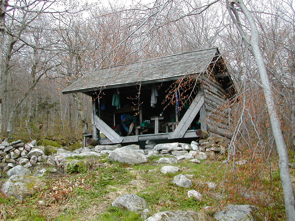
 Shelter from the Elements |
We got passed by 3 hikers from Pennsylvania moving very fast to Cheshire. They were doing 5 sections (about 50 miles) in SOBO order, but traversing the sections NOBO!!. Go figure. It was probably to minimize car movement and shuttling. They were a diverse group: a 30s guy, a 50ish guy a 70ish guy and a dog. And the oldest guy was the fastest of all.
It was good hiking weather, cloudy with temperatures in the 50s. No real rain as yet. Warner Hill was interesting: there was an old apple orchard on the summit. We also crossed over Tully and it was all very easy going. We stopped at the Kay Wood lean-to and there we met Ellis the ridgerunner. We had seen his entries in several registers and it was nice to meet him. He told us about the guy who went over the cliff at Bear Rock and we chatted about his job and his duties as a ridgerunner. He seemed part trail maintainer, part rules enforcer and part educator.
 Fresh Air and Ellis the Ridgerunner at Kay Wood |
The last bit was not bad - we went over Day Mountain and down a steep but very well constructed trail down a switchback and down into Dalton. We were talking about how the book said to be careful in crossing the railroad tracks when just then a fast freight came rumbling by not 100 yards in front of us. We crossed the tracks (carefully!) after the train and made our way into town. We found a nice lunch place, Duf & Del's, where we had a leisurely and enjoyable meal. They had a hikers register which they asked us to sign and were very nice to us. Nice food, nice people, nice town.
 Duf & Del's in Dalton |
In the afternoon we crossed a number of ridges and finally found our way to Crystal Mountain Campsite. Just as we arrived on the short side trail we saw another hiker just in front of us. he had come from the north and went off to one side and immediately started to pitch his tent. He was not talkative when I said hello, but he came over later and offered us some bug stuff. We had finally gotten to an area with black flies - the real thing! These were no gnats. He introduced himself as Frank, from Orono Maine. Frank said Maine was infested with black flies.
 Crystal Mountain Campsite |
Obviously we were in our tents early, and I caught up on my log and my reading. It had been a good hiking day and things were feeling pretty good.
uring the night I heard first a distant coyote and then some very loud nearby owls. Then around midnight I heard the patter of rain on the tent fly and then towards morning the rain sound turned to snow sound. By 6:00 AM it seemed like chunks of snow were buffeting the tent. At first I thought Fresh Air was throwing snowballs at the tent, but it was stuff falling from the trees onto the tent. When I crawled out of the tent, there was a good 2 inches of snow on the ground. The snow was still falling rapidly so we packed up quickly. Most of my stuff stayed dry but the tent of course was wet, and I ended up just stuffing the tent fly into the pack without even putting it into the tent bag. We looked over to where Frank had camped, and found that he was up and totally gone by the time we crawled out of our tents. His footprints were even snowed over. Early riser!
 Morning Snow on Crystal Mountain |
We passed over The Cobble with views of Cheshire through snow and mist. We descended into Cheshire where the snow became very wet sleet. Practically rain. We spoke to the lady in the post office (which opened early for a Saturday morning) and she recommended the Lakeside Restaurant. We were directed to take a path on an old rail bed. As we walked along this we were at first disconcerted since we soon left all signs of the town and seemed to be in the middle of nowhere. But soon we saw a flashing yellow light and got to a highway and found the restaurant overlooking a large reservoir. It was now raining fairly heavily. We got inside, dropped our packs and got our raingear off. We had a scrumptious breakfast, dried off a bit and then got ready to go on again. A man with a red pickup who spotted us as hikers, offered to take us back to the trail by the post office. As he drove us back, we realized that the path we took along the rail bed was actually a pretty good shortcut. If you come into Cheshire, make note of this.
Now, standing in the rain on School Street in Cheshire we had before us the biggest climb we had yet to face in all our hiking from the Delaware Water Gap. We were to climb over 2500 feet from where we were to the top of Mount Greylock over a distance of around 8 miles. Greylock, at 3491 is the highest point in Massachusetts and is what I would call a "near 3500 foot" peak. In fact the monument on it's summit rises well above 3500 feet. Fueled by the recent breakfast of pancakes, bacon, potatoes and lots of good coffee, we were off.
We went up the street, across a field and into the woods. We soon met a young woman coming down who said "it's a bit slippery up there". The rain became sleet and then snow. We trekked through first an inch, then two, then 4 and finally 7 to 8 inches of snow cover. But the going was never too tough and some of the rock scrambles (we assume there were rocks under there) were actually easier. More traction and less worry about where to step. Just do it.
 A Hidden Pond near the Greylock Summit |
 Safe and Sound at Bascom Lodge |
hat a beautiful morning. The sun shining on the new untouched snow was breathtaking. We put our stuff together and after a huge breakfast served up by John, and were off by 8:00 AM.
 Bascom Lodge |
 Starting down through the snow |
The snow was deep under foot. It took a while to find the trail. The Balsam Fir near the summit was heavily laden with snow and we repeatedly got snow dumped on our heads, down our necks, etc. But it was fun, like being kids again. We worked our way down to Mount Fitch and then Mount Williams and finally made our way over to the Wilbur Clearing Lean-to. This was a nice lean-to and was in good shape, but let's just say we were rather more comfortable in the Lodge at the summit. Finally we made our way to the lookout point on Mount Prospect and we could see Williamstown laid out below us. And it was green, not white.
 Williamstown from Mount Prospect |
I couldn't help but recall the words from my school song:
|
O proudly rise the monarchs of our mountain land (Washington Gladden, Williams class of 1859) |
We worked out way down the steep northern slope of the mountain (much steeper then the southern approach we had come up from Cheshire) and soon the snow cover became 4, then 2 inches deep and then just patchy. We were moving from Winter quickly back to Spring. Then one of those "It's a small world" things happened. We passed a 60ish woman who was slowly working her way up the steep hill. We chatted and she said her name was Dot and had come down from Maine yesterday through the snow storm and was taking this sunny morning to complete the section from North Adams to Mount Prospect. Evidently this small piece was one of the sections of the AT on her list to complete. I have no idea of how much she had done, when she started or when she might finish, but she, like ourselves, was out doing it, and that's the important thing.
As we were about to part our ways, I asked "What part of Maine are you from?", "Damariscotta" she said. "O, my son got married there a couple of years ago". "He did, does he live there now?". "No, but his in-laws do.". "What are their names?" "Barbara and Fred K.". "What? They're good friends of mine. They're part of our walking group. I've known them for years". It's a small world, yes indeed it is.
We worked our way down, down, down to Route 2. It was one of those makes-your-knees-wobbly descents.
We made it to the road and walked about a half mile towards Williamstown and got some lunch at the
cafe counter of a huge Stop and Shop super market. It was there that an old gent asked us if we
were hiking the Long Trail. We said we were. Looking back at
Mount Greylock we saw that from here it
looked all green. Had it all been a snow filled dream?
 Stepping stones on a wet trail |
We saw first hand the way elevation, latitude and weather can mimic climate in our descent from Stratton on day 9. From heavy snow cover under Balsam Fir near the top, down through Red Spruce, mixed hardwoods (not yet in leaf) and finally to very a green deciduous forest at the lower elevations.
The other word I would use is "wild". Towns were few and far between and cross roads were more often than not unpaved Forest Service roads. Cell phone reception was largely non-existent. From the lovely southern New England valleys with their farms and towns in Connecticut and Massachusetts, we encountered only forest for miles and miles in every direction. Even from the top of Stratton Mountain, the highest peak we climbed, there were only forests and mountains to be seen in all directions. Nearby towns such as Bennington and Manchester were hidden from view. We could, just for a moment, pretend were were in a forest before the Europeans arrived. But then we would soon come back to the trail with it's fellow hikers, shelters, stone and log steps, etc and we knew we were in the 21st century. As many others have been before us, we were torn between our appreciation of the well maintained trail and it's amenities on the one hand, and the feeling that we wish the place were more wild - totally wild - on the other. But of course then we wouldn't really belong there with our high tech equipment, freeze dried food, fleece clothes and digital camera. The thought would reluctantly pass, and we would hike on - enjoying the beautiful scenery. We look forward to the even wilder and more remote places that await us as we work our way north to Katahdin.
We walked back to the trail and started up towards the Vermont line and on towards the Seth Warner Lean-to, our day's goal. Soon we met a 60ish gent walking south, who said he was the "support team" for 3 fellows up ahead who were hoping to hike to Manchester in 6 days. He had hiked the first few miles with them and was now returning to his car. We told him that was our destination too and we would say hello if we caught up with them. Then moving on, we met a young guy who was trying to filter water in a stream but whose filter was broken. He asked if he could borrow ours and said we could go on ahead and he would catch up with us and give it back. This seemed like a dubious idea so I said "we'll wait". He quickly pumped a liter, drank it, then pumped another to carry, gave the filter back and was off. We would not see him again.
 At the Vermont State Line, Start of The Long Trail |
We finally made the state line and saw 3 more college age guys fooling with their packs and duck taping their feet. They too were going to thru-hike the LT. One of them took our picture at the state line and we went on. Later that night they showed up at the shelter. Finally, just before we got to the shelter, we caught up with the 3 guys who had been described to us earlier by the "support team" gent. They looked pretty tuckered out. We said hello, told them we had met their friend and went on ahead.
When we got to the shelter, there was a French Canadian couple playing with a smoky wood fire who had pitched their 2 man tent INSIDE the shelter!. They asked if we were staying and when we said yes, they moved their tent outside. Then the 3 older gents showed up followed by a guy named Dexter (who we would hike with for the next couple of days). Finally the 3 guys from the state line eventually made it and at that point we had 11 at the shelter.
 Dexter and The Old Vets at Seth Warner |
Eventually everyone ate, cleaned up and drifted away and we got a good night's sleep, our first night in Vermont
e were up as usual by 6:00 AM. Dexter, who was with us in the shelter, was the only other one who was up early, the rest were quiet in their tents except the Canadian couple who had gotten an even earlier start. We got off by 7:15. Dexter was still fiddling with his pack and shoes. As we left, the Old Vets had rolled out of their tent. As we said good bye, one of them asked us what our pack weight was. I said about 35 lbs (probably a slight overestimate). He didn't say anything but he gave an envious look like he probably was carrying much more than that.
The hiking was not too bad - good hiking weather. At the first viewpoint (the book called it an unnamed peak at elevation 3000'), I took off my rain pants (which I wore for warmth) and stripped to my fleece shirt and shorts. We passed the Canadian couple later in the morning and curiously, although they seemed to be making similar daily mileage as we were, we did not see them again.
We passed some nice ponds and an impressive beaver dam that was shaped like a horse shoe and must have been 8 feet high. Later we reached a more impressive one: it was built up against the log bridge (truncheon) along the outlet of a pond and the pond level was about a foot above the trail and was flowing over it. Those busy beavers! The trail was almost always wet, but most sections were well built with stepping stones or logs, but an occasional mud patch was encountered.
 Beaver Dam built against a Truncheon |
It had become cloudy and there were a few snow flurries. It was quite cold when we stopped, but was a good temperature for hiking. We stopped at the Congdon Shelter for lunch. Dexter had earlier passed us and was also at Congdon. The weather was nice when the sun came out, but otherwise a bit chilly.
The afternoon walk was similar. We moved through a mixed Beech / Birch forest which was still not in leaf. It brought back memories of our April hike through New Jersey and New York. Spring is slow to come in the high points of New England. After enjoying a nice view from Hamlin Hill, we made a very steep descent to Route 9. The stone work here was impressive. Again and again I was impressed with the trail building in Vermont, known for very wet and rugged territory. They have done a great job on these trails. We took a short break at the stream next to the highway and met 2 young college aged guys fiddling with their packs. We got started up the other side hoping to get the jump on them in getting to the shelter which was just a couple of miles past the road. The ascent was as impressive as the descent with impressive stone work. The 2 guys soon bounded past us (ah youth!). We met them a short time later at the shelter. They were Tyler and Mike. They had camped the night before at the top of that unnamed peak we had passed. They too had first gone to Seth Warner, but when they saw the Canadian couple's tent in the shelter they had moved on another mile or so to the hill top. It had an impressive view but would not be my choice for a tent site. Rather cold and exposed..
We arrived at Melville-Neuheim Shelter at around 3:00 PM and a short time later Dexter joined us. It was not large, with double bunk platforms on either side of a narrow center space. We divided up the bunks between the 5 of us. It was cold and cloudy with temperatures probably in the 30s. Soon thereafter 3 more guys (Jake, Matt and Bret) arrived. At first I thought they were the 3 that had been at Seth Warner (the ones we passed at the state line), but it was another group that had actually started the LT from Williamstown that day, and had done over 18 miles. The leader was an aggressive young guy who had laid out plans for 18+ mile days on into the next week. Some of his colleagues seemed a little dubious. As a side note, in all of Vermont I didn't meet a soul, young or old, who used a trail name.
 The Gang at Melville-Neuheim |
Quite a bit later, around 5:30 or 6:00, I was looking around and there seemed to be an extra person. Fresh Air said there were actually two more (Chris and Clint) who had arrived while I wasn't looking. They were the remnant of the group of 3, and had trailed the lead pack by almost 2 hours. This seemed like an unstable group. They prepared supper and they all seemed to have enormous plastic bags full of raman noodles. I guess theirs was a simple diet. Then there was another huge bag of candy bars - the little ones you give out at Halloween, so I guess that was lunch. They were all tired, but nonetheless they were careless with their food. We noticed the next morning that a couple of them had left their food bags just sitting on the picnic table. They won't last the way to Canada that way. If the bears don't get their food, the mice will. Lucky for them it was such a cold night.
Somehow we all squeezed into the shelter - the ground was a bit cold and muddy for setting up tents. There were 2 on top on one side, 3 on the bottom bunk, and two on the floor with about a foot of head room under the bottom bunk. Just their heads were sticking out. Anyone who had to get up for a middle of the night pee was likely to step on a face unless they were very careful. Us 3 older guys were on the other side in relative spaciousness. I thought there were 11 in the Shelter but I can't figure who the eleventh was so I guess there were just 10. It was hard to tell, 10 or 11. When you tried to count them they would move!
he three of us "older" guys were up early. The young folks slept in while we got our stuff together and made breakfast. This was just as well since if all 10 of us tried to get going at once it would have been chaos. It felt cold when we started, especially my gloves which as I said above, were one item of my clothing that was not really up to this weather. Fresh Air had 3 pairs of gloves but he wasn't happy with any of them.
The first couple of miles were fairly easy ups and downs. The trail in this section was mostly dry. At the first break I shed some clothes and was happy to be hiking in shorts and fleece shirt again, with a wind breaker to throw on when we stopped. We hiked along Porcupine ridge and the snow cover was deep again. As we got to Little Pond lookout the snow was 3 to 4 ". It seemed to diminish a little every day, but with the temperatures as cold as they were it never really melted. Up here the trail was no longer a continuous track, but rather little bits and pieces between areas of snow cover. A little later we noticed a strange site to the south west, perhaps 10 miles distant. We saw first 4, then when we looked more carefully, 7 wind generators along the top of the ridge. The had tall towers and 3 very long and slowly moving blades. I know these have been controversial among the environmental community. Some seeing them as an alternative to burning fossil fuel, others seeing them as an eyesore.
 Glastonbury in the distance |
We got a good view of Glastonbury across the next valley, and then made the ascent, stopping at the Goddard Shelter before the summit. This has the most magnificent views of any shelter we saw. We were at Riga Shelter in Connecticut which also has a great view, but that day it was unfortunately raining. The shelter also has a clever design, with a covered porch which stood some 3 feet lower than the main floor. This made a convenient seat and work area. I've heard the black flies are bad here, but certainly you couldn't imagining that on this cold day. It would seem a great place to stay, except perhaps the west facing view and exposure would make it rather cold on nights like tonight. While we were lunching, the 5 fast guys drifted in to join us. First the 3 "fast" fast guys, and then the 2 "slow" fast guys. It turns out they were all students from Plymouth College in New Hampshire and were fairly experienced with hiking, being so close to the Whites.
 The view from Kid Gore Shelter |
The last half mile to the Glastonbury summit was steep with stone steps. The summit itself was a bit of a let down. It had no view, just a thick Spruce forest and an old fire tower which was closed. It was rather windy and cold so we quickly moved on. It had been a good hiking day so far and we only had a few miles to go to get to our target, Kid Gore Shelter. The top of the ridge was rather flat through Red Spruce with a good snow cover, and except for a tough boulder climb, we made it to Kid Gore with little effort.
 Kid Gore Shelter |
Kid Gore has a nice easterly view and seemed to be in a warmer little vale than Goddard. The view was actually cut away forest, big stumps were in evidence in abundance. Although we appreciated the view, I'm not sure it makes sense to cut down a chunk of forest to achieve it. We did our usual chores and then as we were relaxing a bit, lo and behold it started to sprinkle, and then to hail. I brought in the stuff I had set out to dry, and we hoped the folks still on the trail were not getting too wet.
 A rainbow after the rain and hail, seen from Kid Gore |
After the rain and hail abated, the sun shone in patches on the valley in front of us and lo and behold, a rainbow appeared before us across the valley. Beautiful, fragile, and ephemeral. I don't see a lot of rainbows (being from New York City) so this was a special treat to end a great day!
he morning weather was the familiar cold, clear and sunny. If things were true to form it would cloud over by mid day and be rather chill and cloudy into the evening. But somehow I thought today would be different and the weather would change and the cold spell would be broken. But either way it was a great day to be in the woods in Vermont and we were off early. As my log says "Life is good!"
The big job for today was to hike up and over Stratton Mountain (3941'), the highest peak we would see on the entire section hike.
As we got going the temperatures rose to the low 40s but the ground was still frozen with patches of snow. The first peak (an unnamed summit at 3412') was rather tiring but we soon got our second wind. We passed 2 60ish SOBOs who said they had come from Story Spring (the next shelter) and that there were 5 younger guys were there last night as well. So it seems our friends had made it OK to their intended goal for yesterday.
 Lunch at Story Spring |
We stopped for lunch at Story Spring Shelter, empty by this time, and crossed a dirt road (I guess USFS 71) which had posted a notice that the bridge over Black Brook up ahead had washed out, and that we could take a road walk around, or ford it (the sign said remove boots and socks and ford the stream). We said basically "we ain't scared of no washed out bridge" so we went on to see what we were up against. It took a while to get there and we crossed one very deep still stream which made us a bit apprehensive. When we finally got to Black Brook, we found a slightly wider than usual, with heavier than the average flow, but that looked doable at several possible spots. Fresh Air was first and hopped across some rocks and didn't even get his boots wet. Dexter was scouting out another spot slightly down stream, and I decided to follow Fresh Air's route.
 Crossing Black Brook |
We crossed the Arlington-West Wardsboro Road, the end of the Trail Guide Section. You'd think with a name like that it would be a real road, but it was just a well maintained dirt road. There was a parking lot and a sign for the AT and Stratton Mountain and some side trails which lay ahead, and a couple of cars were there. It was still a great day and it looked like we would indeed break the pattern and have sun all day long. There were some bothersome bugs by the road, so we didn't tarry. The climb was a steep but not a killer climb of a little under 4 miles. I was surprised that some of the taller peaks we had done in the last week or so, starting with Greylock and on up to Stratton, were not that daunting. I swear some of the 1400' peaks in New Jersey, with their rock climbs and boulder fields were worse.
Whom should we find when we got to the summit, but 2 of the fast guys. They seemed to be having more problems with their feet. For all their speed they couldn't manage to stay ahead of us by very much. This, even given the fact that they had an almost 5 mile head start for today!
 Stratton Pond from the Stratton fire tower |
The trail down to Stratton Pond was a text book example of the progression of climate vs. altitude.
 Balsam Fir and deep snow near the top |
 Then Red Spruce with less snow |
Near the top we went through Balsam Fir with deep snow cover. Lower we passed through Red Spruce, with open understory and less snow. Then came the Beech / Birch forest, not yet in leaf, with only occasional patches of snow. Then came the Viburnam and other shrubs under the trees, and finally we got to the forest in full leaf.
 Mixed Beech and Birch further down |
 Finally trees in leaf |
In a more gradual and regular way, we made the same progression we had in coming down off of Greylock 4 days earlier - the passage from Winter to Spring in the space of a few miles and a few hours.
 The Stratton Pond "Hilton" |
 Stratton Pond |
It was a perfect place and it had been a perfect day. Life really IS good!
he last day! Tonight I would be home in New York. The temperature was warmer, around 40° (the first above freezing morning in almost a week) with sun. We got an early start at 7:10 AM, although we had a bit of extra mileage to get back to the trail down by the pond. We took a few more photos there and were off. Dexter was still filtering some water but as usual he would catch up later.
 Stratton Pond in the morning sun |
It was a beautiful easy walk through mostly Beech and Birch forests. Some of the huge Yellow Birches were awesome.
 AT Symbol Cut on Log face |
There was one bit of trail of about a mile on a dirt road just past the Lye Brook Wilderness. Why this was a road walk with National Forest in every direction beats me. Good place for a relo.
 Lunch at Spruce Peak |
The last section of trail, out to Route 30 was similar but with a couple of power lines and streams to cross. Finally we got to the road, and took a break. I changed a few clothes, since it was now quite warm, and we found Dexter. He had gone past us while we were at Spruce Peak. Besides saying goodbye (he would be hiking for another week or so up the Long Trail) he said that when he had got to the road, about 20 minutes ago, there were the 5 fast guys hitching a ride down to Manchester. So in 3 days those guys never did get any lead over us!
 The End of the Trail |
We got there about 1:30 and figured we'd have time to kill. I found the bus station. It was a combination dry cleaners, Post Office and bus station. The young woman there did all three jobs simultaneously.
 Heading Home |
We bought some ice cream, waited under a tree and there was the bus, on time we were headed home!
It was great and we did fine.
Seriously, there are a few things we did right and some stuff we learned for next time:
The Weather: unexpected but not a real problem. It was nice we had the Egremont Inn and Bascom Lodge at certain critical points but we know there are always little escapes we can make if we need to. Bascom in the snow on that sunny Sunday morning was out of a story book. I guess every cloud has a silver lining. My friends all seemed to ask "Were you prepared for that weather", the answer is we were PREPARED for it but didn't EXPECT it. More fun that way.
Clothes: The only thing I would second-guess would be to have my heavier fleece shirt with the built in wind breaker shell rather than my plain reversible fleece shirt, AND a pair of wool gloves. But my shirt actually did yeoman duty, and I was warm when I was hiking and when I was sleeping. The in between times I was a little cold. For raingear next time I'm thinking I'll take my Gortex running suit instead of the Frogg Toggs. It's heavier than the Frogg Toggs, but more comfortable inside, sitting around camp, etc. It should also be warmer (since it's lined) when used for insulation rather than just rain in the Whites.
Boots: For the last section hike (New Jersey and New York in April) I wore trail running shoes (NB 905s). I decided to switch to boots since the running shoes didn't hold up well to the rocky terrain, didn't give enough toe support, and got wet all too easily. I'm glad I switched: I got a pair of EMS lightweight Gortex lined boots (Mirage II) - they were very good. A few blisters at first but they generally kept me warm and dry under very wet and cold conditions. A slight soreness on my right instep bothered me. I need to put a little padding there.
Food, cooking: Fine. We seemed to have perfected the fast boiling water / ziplock bag method. We both had Pocket Rocket butane stoves and we were always faster, lighter, cleaner and easier than any of the others we met. The ziplocks served as storage package, cooking pot and bowl. We simply poured the boiling water into the ziplock containing the dried food, sealed it, jostled it a bit to mix everything, and waited the few minutes needed for the food to "cook". While the food was "cooking", I would put away my whole stove and fuel setup and sip my drink. When the food was ready to eat we would put the ziplock into the titanium kettle we had used for boiling, and this gave the "bowl" the stability it needed. Neat and clean. Except for rinsing out my cup and licking my spoon there was literally no cleanup. We set up, ate , and were done, period. The freeze dried food (I know, a bit pricier, but well worth it to me) worked very well.
Other Stuff:
|
Click here for a complete album of photos from this hike Click for Papa Bear's Home Page Click for the Backpacking Page |